Most of the things brought up in the OP have been adequately answered, but the last needs comment.
read and think. duplicate these proofs for yourself: https://www.amazon.com/Zetetic-Astronomy-Earth-Globe-Forgotten/dp/1605064173/ref=sr_1_1?ie=UTF8&qid=1495449465&sr=8-1&keywords=zetetic+astronomy+earth+not+a+globe
Ah, good ol' EnaG. That book contains no proofs. It's all handwaving, misinterpretation, misdirection, and flim-flam.
The link above is for a republication by
Forgotten Books of the 1881 Edition. Forgotten books; there's a good reason this volume is in that category.
It's also available online for free. A scanned version of the 1864 edition is available as a pdf file from Google Books.
https://www.google.com/url?sa=t&rct=j&q=&esrc=s&source=web&cd=3&cad=rja&uact=8&ved=0ahUKEwjEpK2JvobUAhWqslQKHcvHA_MQFgg0MAI&url=http%3A%2F%2Fwww.theflatearthsociety.org%2Flibrary%2Fbooks%2FEarth%2520Not%2520a%2520Globe%2520(Samuel%2520Rowbothan).pdf&usg=AFQjCNF3jxs2DpXiKTgToOA67_WeP6BHOg&sig2=90SGkCPhj5h4aPo5XVRIMAThe 1881 edition, converted to text along with each figure as a separate image, is here:
http://www.sacred-texts.com/earth/za/ There are some OCR errors in the text conversion, and there are differences between the 1864 and 1881 editions, but comparing the text version with a hard copy or the scanned image might be helpful if you need to resolve a transcription error.
Anyway, if you think some "experiment" or other topic in EnaG is compelling, why not start a thread for it in the Debate forum? Maybe quote the main point and perhaps germane remarks from the OCR text and embed images from the on-line version, with a link to the section they were taken from, then state your own comments, conclusions, or questions.
For example:
EXPERIMENT 8."Looking across Spithead to the Isle of Wight, the base or margin of the island, where water and land come together, appears to be a straight line from east to west, a length of twenty-two statute miles. If a good theodolite is directed upon it, the cross-hair will show that the. land and water line is perfectly horizontal, as shown in fig. 19."
FIG. 19.
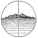
FIG. 20.
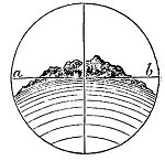
"If the earth is globular, the two ends east and west of the Isle of Wight would be 80 feet below the centre, and would appear in the field of view of the theodolite as represented in fig. 20."
There are obvious errors in his hypothesis that invalidate the experiment. Do you recognize any of them?
Enjoy! This could be fun!

This is typical of everything in that book. It should have remained forgotten.