On the contrary. I grew up with round Earth science. Elementary school, middle school, high school, and finally college.
And you clearly didn't care enough to pay attention and actual retain any of that knowledge.
Not only do you not properly understand how a flat Earth works, you do not even really understand your own theory.
You sure do love projection don't you?
I understand a variety of FE models, and the mainstream model, quite well.
It is you that has been repeatedly spouting pure garbage, refusing to defend the FE model and instead literally ignoring problems with it, while continually spouting complete falsehoods about the RE model.
The nonsense you are spouting would be quite clearly nonsense to anyone who has taken basic mechanics.
The navy or whatever guy pointed south precisely because he, like most of you, do not understand the purpose of lines of latitude.
They pointed east, which if you continue in a straight line would end up being south for that FE map.
In fact, for that FE model, if you pick any location and any direction, after long enough, it is going roughly south.
As for latitude, that is just another thing which makes no sense at all on a FE.
On a FE, while you can justify the longitude being an angle, it should be using polar coordinates, with a radius and an angle.
An angular measure for distance from the north poles makes no sense.
But for a RE, it makes sense to use an angle for both, as you are describing a location on the surface of a sphere.
You could use 3 coordinates, to also include the radius, but that would be fairly constant at roughly 6400 km.
But notice how yet again, you just deflect the BS you have spouted and had refuted.
Instead of focusing on the fact that Cook's journey couldn't have been undertaken on a FE because of the distances involved, you just ignore that and jump on this BS.
Btw, no maps agree on this, so you'd need to make three trips around the world.
Wrong again.
The RE maps do agree on this. You refusing to understand the projection involved doesn't change that fact.
But even if you did want to ignore that, you don't need to make three trips around the world.
You just need to measure the length of a change in longitude at a given latitude.
For example, you can determine how long 15 degrees of longitude is at each location.
And a good example of that is Australia, which the FE garbage has far too wide.
Most world maps depict the Earth not as a flat ever-expanding disc, nor even a globe. If we have equal lines of latitude as in the average map, we are really looking at a cylinder.
Only to those who wish to remain wilfully ignorant.
Most world maps depict Earth as a globe, using a known projection.
Round Earthers often talk about how in flat Earth airplane flights have to adjust constantly
How many do that because they genuinely think that, vs how many are just doing that to point out the stupidity of FEers claiming planes need to constantly tilt down?
Flat Earthers know that they are working in theory
No, FEers foolishly believe they are working in theory, while in reality they are working in fantasy, refusing to even try to make a hypothesis which can be tested because they know that when they do, their model falls apart as it doesn't match reality.
So yes, I am more familiar with your own system than you.
Then why do you keep spouting such ignorant garbage about it, getting even incredibly basic things wrong?
You either don't know very much about it and are vastly less familiar with it than me; or are you being intentionally dishonest by pretending there are problems when you know that what you are spouting is false.
Which is it?
Btw, youguys didn't even get Cook's circumnavigation route right. He did check the upper sections.
Wrong again.
You sure do love being wilfully ignorant don't you.
Did you bother reading what I said? Here it is again:
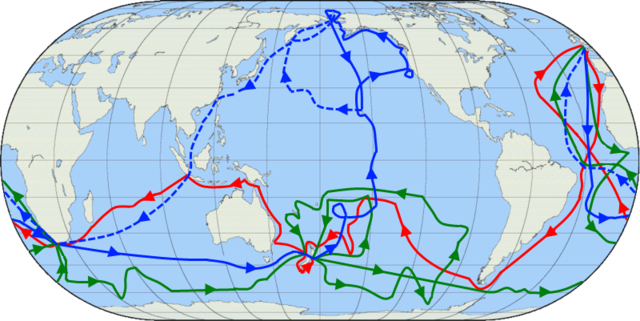
FEers will normally focus on his second voyage, as that included circumnavigating Antarctica, and it took a roughly 3 years, starting on 13 July 1772, and ending on 30 July 1775.
Notice how I appealed specifically to his second voyage?
What you have shown are the three voyages.
In your image, the red line is the first voyage, the green one is the second, and the blue one is the third, with the dashed portions occurring after they did.