Hello all,
I'm new here, could one of you Flat E's please explain how the world time zones fit in with your hypothetical world ?
How does the sun move around, etc. ??
The sun circles above the flat earth.
This is an accurate picture of the details involved:
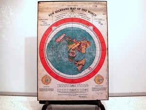
As it states on the map, it is depicted AS "IT IS" without dispute!
Congratulations for posting a projection of the Globe but that map does give a good depiction of the time zones around the Globe.
You did read the "ON THE PROJECTION OF J.S. CHRISTOPHER . . . . SCIENTIFICALLY AND PRACTICALLY CORRECT AS "IT IS"
If it were a map of your flat earth there would never have been any need for a "projection". All that would be needed would have been for it to be a scaled down drawing of the earth.
There is more to it than that but that is what the map says and that is what it is, and it is:The azimuthal equidistant projection is an azimuthal map projection. It has the useful properties ... for star maps in some holy books, the earliest text describing the azimuthal equidistant projection is an 11th-century work by al-Biruni.
And Al-Biruni certainly believed the earth to be a Globe as is attested by works and writings.
The map is not a projection and Christopher did not create it.
Familiarize yourself with the word extorsion.
So sorry it very clearly states that is is a projection: ON THE PROJECTION OF J.S. CHRISTOPHER.
I was created for Gleason who really was an "ardent" flat-Earther:Alexander Gleason, a civil engineer from Buffalo, NY, tested the flatness of the surface of lake Erie. He published Is the Bible from Heaven? (1890) and Is the Earth a Globe? (1893).
It was created based on "the projection of J. S. Christopher" though, I agree it was not created by J. S. Christopher.
I believe Gleason patented it as a time chart because there is no way that the US patent Office would patent a  Flat Earth Map !
And yes, I know what "extorsion" means.
You might like to read: Gleason's Map and here is a little extract:Well, we certainly know what he said on his US Patent application from 1895. Here is Gleason's concept drawing as submitted:
You can read the entire patent, which describes the map's use as a time calculator for students. But the most important passage from the flat-Earth standpoint is this:
| | The map is not so extorted as to lose the relative latitude and longitude of any places on the land or sea, but retains all latitudes and longitudes of places agreeing with other recognized authors; and as the proper relations of continents and countries all stand in their relative position to each other, they are thus impressed upon the mind of the student. The extorsion of the map from that of a globe consists, mainly in the straightening out of the meridian lines allowing each to retain their original value from Greenwich, the equator to the two poles. |
The use of "extorted" in the sense of "distorted" is interesting here, but the intent is clear; the map is not "as it is" (which I think may have been a slogan of the map's publisher), but a projection that preserves the positions with regard to longitude lines, but not the distances between them (distances between lines of latitude, however, are preserved). And note his phrasing "the equator to the two poles." A flat Earth does not have poles.
From: Gleason's Map
Just note again that bit from the patent application: "The extorsion of the map from that of a globe consists, mainly in the straightening out of the meridian lines allowing each to retain their original value from Greenwich, the equator to the two poles."
Just a few comments on Gleason's Map.
"Modern" is a common mis-spelling of "Morden"
Morden College is the only "College" in the Blackheath section of London, England , UK. (Which see)
Morden College is not a college or university, or "place of higher learning " , but is a "collegiate type institution". (Which see for an explanation of the term "collegiate type institution.")
It was established by a wealthy merchant named Sir John Morden; first built from 1695 to 1700 ; as "A retirement home for poor single, widower, or bachelor retired merchants who have lost their establishment." In other words , for poor unfortunate retired merchants who have no income.
Morden College had no information on "J.S. Christopher" other than a Joseph Streep Christopher had met the requirements for residency in his letter for application to Morden College and had been a resident there until his death.
Perhaps "J.S. Christopher" had some interest in maps and had a connection with Gleason as a relative, friend, or acquaintance ?
The English connection is not quite clear ?
Morden College today is a charity retirement home with no requirements for retired merchants and is open to all - elderly singles and couples.
There is an age requirement that residents must be over 55 years old.
Above information from correspondence in an exchange with Morden College.
I believe Gleason's patent was not for the map, but as a time chart.
It is definitely a copy of The North Polar, or Unipolar, Azimuthal Equidistant Projection of the globe. (Which see for comparison.)
The map is definetly a projection, but definetly not "of J.S. Christopher."