Flat Earth Map: The world's most reliable map: 中国是最大的国家。

  • 111 Replies
  • 44366 Views
*

wise

  • Professor
  • Flat Earth Scientist
  • 25446
  • The Only Yang Scholar in The Ying Universe
Sounds like it is a better idea continue this working here. So that, I want to transfer the working to here, part by part.

This is the main knowledge of we'll use.

(shortly)

LAST VERSION OF MAP (Updated 19.08.2019)


BROKEN LINK

Enlarged:


Black listed aircraft companies that manipulate the flight times will never be used:

https://www.theflatearthsociety.org/forum/index.php?topic=74179.msg2019488#msg2019488

I'll add cities from here. Last version of the map is:


This working started and cruise speed of aircrafts come from here: https://www.theflatearthsociety.org/forum/index.php?topic=73165.0

You may follow the previous working at there, then you'll understand why we do continue from here. Then follow the working from this topic.

Meaning of colors

Green cities: The place for city is reliable; corrected ans verified. ✓
White cities: Ordinary places.
Magenta cities: Suspicious place for a city.
Red cities: Yet added cities, did not determined its reliablity.
Blue cities: Sea side cities. May be reliable, non reliable or ordinary. Only shows the city is in the sea side.

Green lines: Circle come from green city shows the distance between cities. Reliable line. ✓
Red lines: Circles come from "red or white" city shows the distance between cities. May be reliable or not. Generally reliable.
Magenta lines: Circle come from magenta city that may be suspicious. Generally not reliable.

Hot line: Equator line.
Center of the map: North Pole. (Will be called after now, as "Ust Yakutsk" (Upper Yakutsk)

Green values: Values are calculated by using the flight times. Generally reliable. ✓
Red values: Values taken from google maps. May be reliable or not.

« Last Edit: December 13, 2023, 02:29:05 AM by wise »
1+2+3+...+∞= 1

Come on bro, just admit that the the earth isn't a sphere, you won't even be wrong

*

wise

  • Professor
  • Flat Earth Scientist
  • 25446
  • The Only Yang Scholar in The Ying Universe
Re: Flat Map Working: The world's most reliable map
« Reply #1 on: February 04, 2018, 11:50:45 PM »
Meaning of colors on the map:

Red: Yet added places
White: Added cities (General places)
Green: Reliable points that corrected by different ways.
Magenta: Suspicious points. Either only google values used, and/or contradicts with other distances.
Blue: Sea side cities added for mapping. Hot line and Antarctic line.
Great Yellow circles: N point. Additionally, for most reliable cities.

Before adding Yekaterinburg, we should to add the Dubai as a strong point. There is a flight everywhere in the world from Dubai; like how Toronto has. So that, it is important. I'll consider that routes:

Dubai   Istanbul 2.992
Dubai   Tel Aviv 2.138
Dubai   Djibouti 2005
Dubai   Addis 2.516
Dubai   Johannesburg 6.428
Dubai   Lagos 5.888
Dubai   Luanda 5.924
Dubai   Delhi 2.201
Dubai   Beijing 5.835
Dubai   Dar Essalaam 3.968
Dubai   Nairobi 3.560
Dubai   Hong Kong 5.941
Dubai   Tokyo 7.926
Dubai   Moscow 3.681
Dubai   Helsinki 4.522
Dubai   St.Petersburg 4.307
Dubai   London 5.670
Dubai   Barcelona 5.162
Dubai   Lisbon 6.132
Dubai   NY 11.004
Dubai   Los Angeles 13.383
Dubai   Toronto 11.065
Dubai   Sao Paulo 12.232
Dubai   Sydney 12.049
Dubai   Perth 9.040

These are google distances. We arrived that shape with these distances:


As we see that, there is almost no relationship between distances. Because these distances are hoax. There is many routes. So that, we'll simplify them by eliminating some of them. We'll create a "critic line", that city must stay near of there, and will delete which lines contains all of this line.

I'm doing it then these line remain:


these are the "worst" circles. If these ones correct the line, then the others already correct. So we'll focus on these routes and find the point that google was trying to deceive us:

New Delhi 2.185 2.434 corrected to 2.583
B788 2:45 879
A320 2:57 832
B77w 2:55 864
Perth 9.040 9.302 corrected to 10.800
B77w 10:11 893
A388 10:25 913
Hong Kong 5.926 5.840 corrected to 5.915
A333 6:49 864
B77w 6:27 888
B744 6:15 893
A388 6:47 908
Istanbul 2.992 3.450 corrected to 3.594
B77w THY 3:49 877
B77w Emirates 4:03 877
Lagos 5.888 6.035 corrected to 6.311
B77L 6:50 885
B77w 6:46 890
Djibouti 2.005 2.599 corrected to 2.355
B738 3:09 825

We could not find Tel Aviv flight. So decided this one as a hoax. With using distances depend on flight times:


With these corrections, Dubai is added. Most of the other distances from Dubai are wrong on google map but I don't spend time for it.

As a result, Dubai was not a perfect point, but added as satisfactory. It is not colored as green.


Astana stayed close to the Dubai. But we know that Russian cities are generally wrong estimated. Astana is already colored magenta and will be corrected later.
« Last Edit: February 19, 2018, 01:56:32 AM by brotherhood of the dome »
1+2+3+...+∞= 1

Come on bro, just admit that the the earth isn't a sphere, you won't even be wrong

*

wise

  • Professor
  • Flat Earth Scientist
  • 25446
  • The Only Yang Scholar in The Ying Universe
Re: Flat Map Working: The world's most reliable map
« Reply #2 on: February 05, 2018, 02:01:45 AM »
Yekaterinburg

Yekaterinburg   St.Petersburg 1804 1.820 (3,5% considered)* co correction is needed.
A319 2:18 819
A320 2:22 819
B738 2:14 823
Yekaterinburg   Moscow 1.437 1.868* corrected as 1.263
A320 2:12 890
A321 2:02 890
B738 2:17 894
Yekaterinburg   Helsinki 2.093 2.242* corrected as 1.965
A319 2:49 825
Yekaterinburg   Istanbul 2.884 3.118* corrected as 2.870 (google distance for Istanbul is true)
A319/320 3:50 843
Yekaterinburg   Tel Aviv 3.397 3.974 No correction is needed. Proven as 3.974
A319 4:50 852
Yekaterinburg   Harbin 4.541 4.733 corrected as 3.061
A320 5:45 853
Yekaterinburg   Beijing 4.369 4.198 corrected as 3.435
A319/320/321 5:06 853
Yekaterinburg   Dubai  3.532 3.585 corrected as 3.261
A319 852 4:14
B738 856 4:28

Yekaterinburg perfectly stayed in all the circles. There was a great green circle comes from St. petersburg. So that, Yekaterinburg movet its new point intersects with the circle comes from St. Petersburg that the reliable point.


Yekaterinburg is re placed and as a result moved its real place and marked as "green" as a second reliable point in Russia. Whole distances are corrected in this respect.

1+2+3+...+∞= 1

Come on bro, just admit that the the earth isn't a sphere, you won't even be wrong

*

wise

  • Professor
  • Flat Earth Scientist
  • 25446
  • The Only Yang Scholar in The Ying Universe
Re: Flat Map Working: The world's most reliable map
« Reply #3 on: February 05, 2018, 03:08:54 AM »
Astana

Re placing the Astana by using flight times:

Astana   Dubai 3.180 3.258 as same as 3.258.
A320 4:05 852
B738 3:58 856
Astana   Istanbul 3.428 3.536 corrected as 3.485
B320 4:17 852
B738 4:18 856
Astana   Moscow 2.296 2.622 corrected as 2.245
A321 3:13 832
B738 3:18 836
Astana   St.Petersburg 2.728 3.145 corrected as 2.853
E190 3:52 843
Astana   Yekaterinburg 945 1.083 as same as 1.083
E190 1:27 774
Astana   Beijing 3.656 3.988 corrected as 2.602
A320 4:51 852
Astana   Delhi 2.545 3.148 corrected as 3.859
A320 3:53 840
Astana   London 4.802 4.964 corrected as 4.795 (google value is true for London)
B752 5:56 867

Astana is added and "has color of magenta the Novosibirsk" is deleted for re placing.

1+2+3+...+∞= 1

Come on bro, just admit that the the earth isn't a sphere, you won't even be wrong

*

wise

  • Professor
  • Flat Earth Scientist
  • 25446
  • The Only Yang Scholar in The Ying Universe
Re: Flat Map Working: The world's most reliable map
« Reply #4 on: February 05, 2018, 03:34:03 AM »
Novosibirsk

Re placing the Novosibirsk.

Early calculated values (Green values)

Novosibirsk   Astana      869
Novosibirsk   Yekaterinburg   1488   
Novosibirsk   Moscow   2727   
Novosibirsk   Beijing   3193   corrected as 1.972 (suspicious)
Novosibirsk   Hong Kong   5072   corrected as 4.427

Novosibirsk is added as a white point. (temporary red). Color of Beijing and Harbin turned to magenta as show its turned to suspicious. Because for a third time, Beijing seems far than shown in the map. So that, Beijing will be re placed. I hope it will be turned to green. Yakutsk and Kotelny islands are deleted. They were added as center by considering other cities. But many of other cities changed. So that they will be added again later.

1+2+3+...+∞= 1

Come on bro, just admit that the the earth isn't a sphere, you won't even be wrong

*

wise

  • Professor
  • Flat Earth Scientist
  • 25446
  • The Only Yang Scholar in The Ying Universe
Re: Flat Map Working: The world's most reliable map
« Reply #5 on: February 05, 2018, 04:06:43 AM »
Beijing

Re placing the Beijing.

(Green values for Beijing)

Tokyo   Beijing   2268      
Lisbon   Beijing   9675      
London   Beijing   8486      
Sydney   beijing   9319      
Los Angeles   Beijing   10218      
Johannesburg   beijing   12037      
Istanbul   Beijing   7767      
New York   Beijing   11495      
Tel Aviv   Beijing   7665      
Moscow   Beijing   6263      
New Delhi   Beijing   4669      
Hong Kong   Beijing   2301      
PANC   Beijing   6911      
Dallas   Beijing   11509      
Singapore   Beijing   5089      
Jakarta   Beijing   5731      
Manila   Beijing   3284      
Helsinki   Beijing   6720      
Denpasar   Beijing   5506      
Aukland   Beijing   11512      
Toronto   Beijing   10.573 red value as same with green value.
B789 12:05   912
B77w 12:40   896
Astana   Beijing   3926      
Yekaterinburg   Beijing   4165      
Novosibirsk   Beijing   3193      
Amsterdam   Beijing   7815      
St.Petersburg   Beijing   6274      
Yekaterinburg   Beijing   4198      
Dubai   Beijing      5835   red value

Circles for Beijing


Do you see how they are perfectly overlap?

There are 28 circles in this shape. And whole 28 circles encircling a place that I'll hatch it for you see how Beijing placing perfectly.


In this diagram, the area colored with red hatch the new place for Beijing. Everywhere in this area possible. But we'll choose it by a few focus and determine a best point. And this point is reliable because corrects the whole map.


With this place, Beijing has moved about 500kms North-East and turned to its color green from white.

As a result;

Beijing is re placed as the 7th reliable point of the map.

1+2+3+...+∞= 1

Come on bro, just admit that the the earth isn't a sphere, you won't even be wrong

*

wise

  • Professor
  • Flat Earth Scientist
  • 25446
  • The Only Yang Scholar in The Ying Universe
Xi'an (East China)

Depend on reliable points, we can find out remain cities with a better estimation. We are adding this site for increase central cities in China. After that, we will have a chance to find other cities in China and whole Russia.

As you know that, in my opinion China is bigger than shown in the map. So I expect that whole distances in China should be bigger than red (google hoax) values. I hope I'm right.

Xi'an   Beijing google value= 935 ?? calculated value= 1.334 overlapped value=
A320 1:40 774 1244
A333 1:50 783 1436
B738 1:42 778 1323
Xi'an   Hong Kong 1.443 2.240
A320/321 2:41 790 2120
A333  2:58 795 2359

I hope you aware of how inside Chinian cities far to themselves! How distances are longer than google hoax/lie values!

Xi'an   Singapore  3.717 4.601
A320 5:24 852
Tell me, if Xi'an were just 3.700kms far to Singapore, why pilots never run to Xi'an inside 4 hours?? (4 hours is possible with a B789 or A388, if it could be really 3.700kms)

Xi'an   Tokyo 2.872 3.222
B738 3:49 848


Take care how it overlaps with these "big" values.

As a result, Xi'an is added as a good point in China and colored white as an ordinary place. The other sides of the China will be more interesting. Because only when corners are reveraled then we can understand the real size of China.

1+2+3+...+∞= 1

Come on bro, just admit that the the earth isn't a sphere, you won't even be wrong

*

wise

  • Professor
  • Flat Earth Scientist
  • 25446
  • The Only Yang Scholar in The Ying Universe
Ürümqi (North West China)

Ürümqi   Beijing
Ürümqi   Xi'an
Ürümqi   Hong Kong
Ürümqi   Dubai
Ürümqi   Novosibirsk
Ürümqi   Astana
Ürümqi   Moscow
Ürümqi   Saint Petersburg


We'll continue with Ürümqi (Urumçi) tomorrow...

With looking the upside image, estimate the place of Urumqi before we done it.  ::)

1+2+3+...+∞= 1

Come on bro, just admit that the the earth isn't a sphere, you won't even be wrong

*

wise

  • Professor
  • Flat Earth Scientist
  • 25446
  • The Only Yang Scholar in The Ying Universe
Ürümqi

Ürümqi   Beijing 2.434 2.806 2.707 same.
A320/321 3:32 835
B738 3:17 840

Ürümqi   Xi'an 2.108 2.359 2.276 (either Sichuan: 1.642 or others 2.488) corrected as 1.961. Sichuan airlines black listed (Provide wrong information)
A319 2:31 Sichuan airlines. If these times are wrong or the others. If these are wrong, Sichuan Airlines go to black list. 830
A320 3:00 China Eastern 830
A321 3:15 China Eastern 830
B738 3:03 Okay Airways 835

Ürümqi   Dubai 3565 5.113 4190 corrected as 2.080
B738 5:04 857

Ürümqi   Novosibirsk 1.283 1.986 1.916
E170 2.32 784

Ürümqi   Astana 1.437 1.520 1.466 google value sounds like true for this time.
B752 1:54 800

Ürümqi   Moscow 3.734 4.529 4.370 corrected as 3.572
B738 5:16 860

We see the perfect intersection for Urumqi except Dubai.


We may examine Dubai problem. Wht did it occur?

Ürümqi   Dubai 3565 5.113 4190  2.080
B738 5:04 857

Google value 3.565 sounds like better than flight value as 4.190. And 2.080 is really close compared to 3.500. If they are really close like this, why Chinian pilots are running about 5:00 hours?

If we examine the path, so we see pilots are running above Iran, Turkmenistan and Uzbekistan and Kirgizistan, passes from Astana then Urumqi. We have Astana in our map so estimate the route like follow:


Take care where is Astana. China Southern pilots are using the route passing from a few south of Astana. This choice makes the flight time 100% more! So that, they run 5:00 hours, alltough 2:30 hours is possible!

This is not a bad intention. It is an ignorance. So that I'll not get China Southern to the black list. To be ignorant isin't a bad mind. 8)

We'll be sure is these cities really stay at there, after more cities added the map. Then I'm sure Chinese pilots who running between Astana and Dubai will shame on themselves.

As a result, Urumqi is added as a good point in the map.

« Last Edit: February 05, 2018, 10:35:08 PM by brotherhood of the dome »
1+2+3+...+∞= 1

Come on bro, just admit that the the earth isn't a sphere, you won't even be wrong

*

wise

  • Professor
  • Flat Earth Scientist
  • 25446
  • The Only Yang Scholar in The Ying Universe
space of ads

Which one is bigger, Russia or China?


Count the squares. And consider that an important part of Russia is frozen. And east side of Russia will be shrinked soon, because Anadyr isin't far like that. Has  Russia big meadows and mountains in fact? Or is it China, but not Russia:


Is it a cardpostal, or a random place in China?


Think on this:


How is it possible a lot of National Parks can stay untouched, while 1,5 billion people are living collectively. If China could be a crowded country, they could eat even the grass on the meadows. But we see many and high areal sized perfect national parks in China.

So China is not a populous country. China is both populous and big as areal size. People do not eat each other caused by hungry. on the contrary, there is a wide range of plains and people live in comfort. if they were the opposite, they could occupied many parts of Russia long ago. no one can stop a hungry person!
1+2+3+...+∞= 1

Come on bro, just admit that the the earth isn't a sphere, you won't even be wrong

*

wise

  • Professor
  • Flat Earth Scientist
  • 25446
  • The Only Yang Scholar in The Ying Universe
Kunming (Southern China)

Kunming   Beijing 2.096 2.552 2.462 corrected as 2.425
A319 (Sichuan Air) 2:35 (irrelevant to others)
A320 (China Southern)  3:03 825
B738 (China eastern) 3:07 830

Take care how other airlines running with closer flight times and how Sichuan airlines running with an impossible flight time. Sichuan airlines black listed. Corrected. It provides wrong information.

Kunming   Xi'an 1.182 1.555 1.500 no correction required. As same as 1.500.

A319 2:05 774
A320 2:00 774
B735 2:08 765
B738 1:54 778

Kunming   Urumqi 2.519  3.409 3289 corrected as 3.173
B738 3:48 (Shandong air)-suspicious 840 (they are running with best flight time overlaps the distance. No correction needed)
B738 4:19 (China eastern) 840

Kunming   Hong Kong 1.161 1.555 1.500 no correction required.
A320 1:53 774
A320/321 2:04 774
B735 2:06 765

Kunming   Singapore 2.647 3.155 3.044 corrected as 2.808
A320 3:40 843
B738 3:48 847

Kunming   Sydney 8.319 8.955 8641 corrected as 8.120
A332 10:19 868

Kunming   Delhi 2.589 2.582 2.491 no correction is required. as same as 2.491
B738 3:04 842

Kunming   Dubai 4.765 4.631 4469 no correction is required. as same as 4.469
A333 5:22 863

Kunming   Moscow 6.215 6.768 6.531 no correction is required. as same as 6.531
A330 7:50 864

Without make any correction:


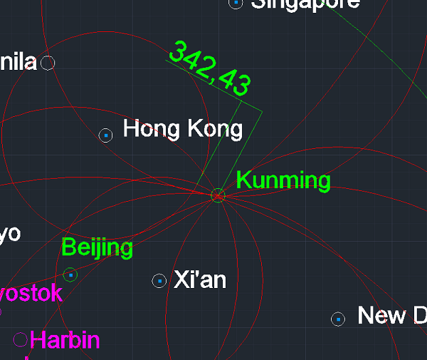
Do you see how it overlaps the whole distances, including Sydney and New Delhi?

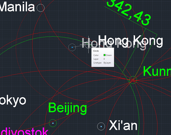
Only Hong Kong is wrong. Either distance, or place of Hong Kong is wrong. But we see that the point of Kunming is definitely in this point. So that we'll move a bir Hong Kong and distance a bit increased. Others are perfectly overlapped. So that Kunming is added as second "green" (reliable) city in China. With it, we can calculate the "shrinking rate" of China that made by google.

After corrections are made, the Hong Kong stays only city out. There is 340kms mistake remained with Hong Kong as follow:


So that, we'll move Hong Kong to the direction of Kunming 340kms. I pre accepted the distance is true.

I drawed the green circle comes from Beijing. So Hong Kong will be moved a point in the aim of correct both distances with Kunming and Beijing as follow:


Distance of Beijing to Kunming is obviously: 2.425kms. If somebody says its fewer than this distance, says lie! These are green points. It means this places are corrected by distances in the whole world and flights between themselves.


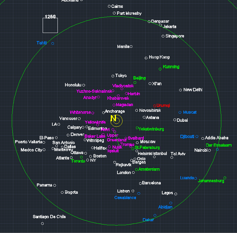
As a result, the place of Hong Kong corrected and Kunming is added as one of the reliable point in China.
1+2+3+...+∞= 1

Come on bro, just admit that the the earth isn't a sphere, you won't even be wrong

*

wise

  • Professor
  • Flat Earth Scientist
  • 25446
  • The Only Yang Scholar in The Ying Universe
Re placing the Harbin.

Harbin

Earlier calculated green distances with google distances together

Harbin   Beijing   1074   1000
Harbin   Tokyo   2133   1617 corrected as same with google distance: 1.617
Harbin   Singapore   5790   5387 corrected as 5.523
Harbin   Novosibirsk   2946   3210 corrected as 2.249
Harbin   Yekaterinburg   3631   4541


Calculated now:

Harbin   Kunming 3.091 3.621 3.494
A320 4:15 852
(if Harbin really close Kunming as 3.091 kms, so why can't smart Chinamen pilots can't run between these cities under 4 hours, like 3:30 or less??)

Harbin   Xi'an 1.935 2.258 2.179 corrected as 2.293
A319 2:41  819
A321 2:46 819
B738 2:48 825

First I used only green cities. There is 3 green circles as follow:


Do you see how they perfectly overlaps? I may write distances on it:


With only green distances:

Yekaterinburg: 3631 / 3631 : 0 % mistake! (perfect)
Kunming: 3494/3494 : 0% mistake! (perfect)
Beijing: 1071/1074: 0% mistake! (perfect)

I'll add other circles to see is Harbin became a green point of not:


harbin turned a perfect point in China corrects whole distances. There is just a mistake seems for distance Novosibirsk. But Novosibirsk as a Russian and white point has the capacity of change its place and perhaps pilots are estimating the point og Novosibirsk as wrong. Anyway.

Harbin turned to green point as show it as a reliable point. Vladivostok is deleted. As a magenta colored suspicious city Vladivostok seems on wrong place. So it is deleted. Perhaps we should delete other magenta colored Russian cities. Anyway. Yet others are not required to move.


As a result, Harbin is turned to the green, reliable point.
1+2+3+...+∞= 1

Come on bro, just admit that the the earth isn't a sphere, you won't even be wrong

*

wise

  • Professor
  • Flat Earth Scientist
  • 25446
  • The Only Yang Scholar in The Ying Universe
We'll continue to revealing the China by calculating the Shangai, the one of the most eastern city in China. There is 5 green cities on our map has flights to Shangai.

Beijing
Harbin
Kunming
Amsterdam
Toronto

I selected 9 others for represant the whole world:   
Delhi
Tokyo
Istanbul
London
Addis
Sydney
Honolulu
LA
NY


If green circles overlaps on a point, and the others seems on a meaningfull distance to the that place, Shangai will be added as a reliable point. If we see some mistakes, it will be one of the white (ordinary) point. I hope we make green it.

Will be continued...
1+2+3+...+∞= 1

Come on bro, just admit that the the earth isn't a sphere, you won't even be wrong

*

wise

  • Professor
  • Flat Earth Scientist
  • 25446
  • The Only Yang Scholar in The Ying Universe
Shangai

Green:
Shangai   Beijing 1.100 1.548 corrected to 1.482
A321 2:02 774
A333 2:04 783
B789 1:47 818

Shangai   Harbin 1.658 2.077 corrected to 2.128
A320 2:46 809
A333 2:21 818

Shangai   Kunming  1.967 2.135 corrected to 2.201
A320 2:36 819
A332 2:39 829
B738 2:32 825

Shangai   Amsterdam 8.919 9.372 corrected to 8.902
A332 10:40 869
B789 10:27 909

Shangai   Toronto 11.429 11.955 corrected to 9.038
B773 13:20 896
B77L 13:09 912
   
By using the green circles:


As we see that, there is a good intersection for Shangai. Not perfect, but good enough. When I intersected the points, distances a few changed. I wrote new distances to beside to green values.

Its temporary colored as green before white circles are created.

White circles:

Shangai   Delhi 4.295 4.630 corrected as 4.448
A333 5:24 864
B788 5:28 902

Shangai   Tokyo 1.741 1.806 corrected as 2.156
A321 2:18 815
A333 2:18 825
B772 2:16 835
B788 2:07 860

Shangai   Istanbul 8.038 8.163 corrected as 7.993
B77w 9:29 892

Shangai   London 9.251 9.279 corrected as 9.143
B773 10:55 893
B77w 10:55 893
B789 10:17 909

Shangai   Addis 8.840 8.409 corrected as 8.523
A359 9:39 903

Shangai   Sydney 7.875 8.447 corrected as 6.761
A332 10:12 868
B773 9:42 892

Shangai   Honolulu 7.925 6.563 corrected as 4.645
B773 7:38 891

Shangai   LA 10.429 9.403 corrected as 8.167
B773 11:09 896
B789 10:48 912

Shangai   NY 11.888 12.116 corrected as 9.011
B773 13:58 899


Corrected with red circles seems good. So that color of Shangai did not changed. It stays green that correct all of distances. There is a few difference with Tokyo but Tokyo will correct later, then it will be correct by itself.

Other distances are corrected till intersect to Shangai and written beside of the green values as corrected values.


Shangai is added as the 8th green point in map and 4th green point in China.
1+2+3+...+∞= 1

Come on bro, just admit that the the earth isn't a sphere, you won't even be wrong

*

wise

  • Professor
  • Flat Earth Scientist
  • 25446
  • The Only Yang Scholar in The Ying Universe
Kathmandu

Kathmandu will be added for delimit the China.

Kahtmandu   Xi'an 2.346 corrected to 1.863
A319 04:25 835

Kahtmandu   Kunming 1.774 2.029 corrected to 1.741
Unknown type China eastern 2:31 830
Unknown type China eastern 2:33 830

Kahtmandu   Singapore 3.541 3.896 corrected to 4.286
B738 4:43 856

Kahtmandu   Hong Kong  2.935 3.204 same as 3.204.
A320 3:51 850
A333 4:03 860

Kahtmandu   Delhi 817 1.055 is not changed. corrected as google value, 817.
A321 1:30 743
B739 1:26 747

Kahtmandu   Dubai 2.995 2.821 corrected to 2.912
A320 3:28 845
B738 3:26 850

Kahtmandu   Istanbul 5.308 5.322 corrected to 6.231
A333 6:23 864

As a result, katmandu is added.

1+2+3+...+∞= 1

Come on bro, just admit that the the earth isn't a sphere, you won't even be wrong

*

wise

  • Professor
  • Flat Earth Scientist
  • 25446
  • The Only Yang Scholar in The Ying Universe
Using the map to find real distances
« Reply #15 on: February 06, 2018, 04:20:48 AM »
To find the real distances, you may use the following "real distances".


Green distances are the most reliable ones. When you search for a distance not on this chart, you may use these lenghts as a comparison chart.

An example:

I'm searching for real place of San Fransisco. I'm opening the google map and find the place of San Fransisco:

The nearest places to San Fransisco are "Toronto and Sao Paulo"  in the map. I'm getting note the distances to these two cities by google map:

San Fransisco-Toronto: 3.625kms.
San Fransisco-Sao Paulo: 10.424kms.

Now. I'll compare the distances between Toronto to Sao Paulo for aim to determine the increase or decrease rate:

Toronto to Sao Paulo on google map: 8.180kms.
Toronto to Sao Paulo on real map (flat map): 7.385kms.

So we understand that real distance in this area is fewer than distances in google map. So we'll shink it.

Shrink ratio is: 7.385/8.180= 0,903.

Now we'll multiply this ratio with distances on google map, then will find real distances as follow:

Real distances are.

San Fransisco-Toronto: 3.625kms * 0,903= 3.273kms.
San Fransisco-Sao Paulo: 10.424kms * 0,903 = 9.413kms.

These are real distances and you can find out true place of the city depend on these distances.

That's all.
« Last Edit: February 06, 2018, 04:22:38 AM by brotherhood of the dome »
1+2+3+...+∞= 1

Come on bro, just admit that the the earth isn't a sphere, you won't even be wrong

*

wise

  • Professor
  • Flat Earth Scientist
  • 25446
  • The Only Yang Scholar in The Ying Universe
Mumbai (Cancelled)

Mumbai in the project of revealing the real size of India.

Green circles:

Mumbai   Amsterdam 6.867 6.924
B77w 8:06 890
B789 7:53 906

Mumbai   Toronto 12.508 12.694
B77L 14:38 899

Mumbai   Beijing 4.769 5.010  corrected as 5.192kms.
A333 6:01 863


success after the distances of Beijing is corrected as 5.192kms.

White circles:   
Mumbai   Delhi
Mumbai   Dubai
Mumbai   Kathmandu
Mumbai   Tokyo
Mumbai   Hong Kong
Mumbai   Addis Ababa
Mumbai   Istanbul

We'll continue the Mumbai later, after New Delhi placed better.
« Last Edit: February 06, 2018, 05:03:32 AM by brotherhood of the dome »
1+2+3+...+∞= 1

Come on bro, just admit that the the earth isn't a sphere, you won't even be wrong

*

wise

  • Professor
  • Flat Earth Scientist
  • 25446
  • The Only Yang Scholar in The Ying Universe
Re placing the New Delhi

New Delhi

(green values)

New Delhi   Beijing   4669
Amsterdam   Delhi   6357
Muscat   Delhi 2136
Dubai   Delhi      2201 (red)
Astana   Delhi   3148
New Delhi   Istanbul   4849
New Delhi   Tokyo   6095
New Delhi   Beijing   4669
New Delhi   Moscow   4957
New Delhi   London   6983
New Delhi   NY   11396

With these distances Delhi seems here:


Stayed close to Dubai and Muscat. So that Muscat is temporary deleted. We'll re place Delhi by comparing and correcting this new point with distances come from green lines. Perhaps, we may only use green lines as a better choice.

Green cities:
Delhi   Beijing   4669      
Amsterdam   Delhi   6357   6.657
B77w 7:30 888 6660
B744 7:27  893 6653
Delhi   Toronto 11.628

Delhi   Kunming 2.589 2.634
B738 3:15 840

Delhi   Shangai 4630

With only green cities the last point doesn't changed so much:


Its corrects both cities and stays in the west and a bit North of Kunmig.


But we need to correct it by comparing the white cities. So that its color changed white again and will be continued. The interesting thing is we can't control Delhi by comparing the distances with Urumqi and Xi'an. These are two close big cities to Delhi but there is no flight between them. Perhaps caused by wrong estimation point for Delhi. Maybe a land traveling is better for them.

meanwhile a distance with Tokyo isn't overlapped and color of the Tokyo turned to magenta to show its suspicious position. We need to correct it and turn to green.

Distance with Katmandu not so changed. Last situation before Delhi corrected by white cities.


We'll continue with control/correct cities by new point for New Delhi. After that we'll continue to revealing the Indian cities.
1+2+3+...+∞= 1

Come on bro, just admit that the the earth isn't a sphere, you won't even be wrong

*

wise

  • Professor
  • Flat Earth Scientist
  • 25446
  • The Only Yang Scholar in The Ying Universe
Which one is the biggest country?
« Reply #18 on: February 06, 2018, 10:55:46 PM »
predictive information

These knowledges may be change but for now, we may estimate the areal sizes of China, Russia and USA.


China: 11 mkm^2


Russia: 7,33mkm^2


USA: 9,22 main country + 1,71 (pre accepted Alsaka) = 10,93mkm^2

So countries by areal sizes:

1- China: 11m km^2
2- USA:  10,93km^2
3- Russia: 7,33 km^2

We'll change these results by adding enough cities permit us revealing the real borders. These datas may be change next with new knowledges but I don't think this ranking will be changed.

China is the biggest country by areal size.
« Last Edit: February 06, 2018, 11:27:21 PM by brotherhood of the dome »
1+2+3+...+∞= 1

Come on bro, just admit that the the earth isn't a sphere, you won't even be wrong

*

wise

  • Professor
  • Flat Earth Scientist
  • 25446
  • The Only Yang Scholar in The Ying Universe
Tokyo

We yet changed its color to magenta for show its turned to suspicious point. So that we'll re place it and try to find a green point for Tokyo.

Green values for Tokyo:

Green values in green cities:

Amsterdam   Tokyo   9305 (red value)
Shangai   Tokyo   1806
Harbin   Tokyo   2133
Tokyo   Beijing   2268
Toronto Tokyo 10.356 (red value)

There is 5 circles in the shape and all are compatibled. There is a point correct the red distances and in about intersection of green circles.


So that Tokyo is agreed as a green point. Control with other cities:

Green values in red cities:

New Delhi   Tokyo   6095      
Xi'an   Tokyo   3222
Hong Kong   Tokyo   2987
PANC   Tokyo   5325
Denver   Tokyo   8893
Singapore   Tokyo   5328
Aukland   Tokyo   9046
Tokyo   Sydney   8223
Tokyo   LA   8264
Tokyo   NY   10862
Tokyo   London   10008
New Delhi   Tokyo   6095

Xi'an  moved through Tokyo about 100kms.


This point for Tokyo verifies all distances. So that, the place of Tokyo is corrected and the color of it changed to green to show its reliablity.

1+2+3+...+∞= 1

Come on bro, just admit that the the earth isn't a sphere, you won't even be wrong

*

wise

  • Professor
  • Flat Earth Scientist
  • 25446
  • The Only Yang Scholar in The Ying Universe
Mumbai

Green values from green cities

Mumbai   Amsterdam   6924
Mumbai   Toronto   12694
Mumbai   Beijing   5192

Mumbai   Tokyo 6.793
B788 7:14 906 All nippon airlines. Impossible flight speed (they claim over 1.000km/h and this is impossible)
All nippon Airlines is added the black list.

White cities:

Mumbai   Delhi 1.139 1413
A320 1:58 774
B738 1:47 778
B788 1:49 818

Mumbai   Dubai 1.928 2249
A321 2:52 819
A388 2:49 870
B738 2:40 823

Mumbai   Kathmandu 1.595 1726
B738 2:15 795

Mumbai   Addis Ababa 3.839 3927
B788 4:31 901

Mumbai   Istanbul 4.824 4821
B77w 5:38 887

Mumbai   New York 13.136 12207
B77w 13:57 896
B772 14:25 888

For the 5th time, sounds like Istanbul should move through east. So that Istanbul moved 300kms through Mumbai. There is almost no close city to Istanbul. Controlled with Amsterdam the green city. Istanbul re placed the possible distance with Amsterdam.


New Delhi a bit moved through North.

Mumbai is added as an ordinary place and has an ordinary color. This place isin't on a perfect intersection but stays inside all the circles. Whole distances are verified.

1+2+3+...+∞= 1

Come on bro, just admit that the the earth isn't a sphere, you won't even be wrong

*

wise

  • Professor
  • Flat Earth Scientist
  • 25446
  • The Only Yang Scholar in The Ying Universe
Hyderabad

Hyderabad   London 7.762 7702
B789 8:48 907

Hyderabad   Delhi 1.267 1518
A320 1:54 784
B77w 2:02 815

Hyderabad   Mumbai 622 932
A319 1:23 700
B738/739 1:22 705

Hyderabad   Dubai 2.548 2673
A320 3:16  840
B77w 3:10 883

Hyderabad   Singapore 3.310 3393
A320  4:10 852
B38m (738) 4:22 856

Hyderabad   Hong Kong 3.750
(Cathay Pasific) A333 4:32 862
(Cathay Pasific) B744 4:14 891
Only one airline company. So that, these suspicious flights. If contradicts to others, so will not be considered.

Hyderabad well placed, except Singapore.


Singapore either wrong placed or there is a manipulation on flight time between Hyderabad and Singapore. For that, color of Singapore turned to magenta to show Singapore turned to suspicious and Hyderabad is added.


Take care India in fact, about 50% bigger than shown in google/fake map.
1+2+3+...+∞= 1

Come on bro, just admit that the the earth isn't a sphere, you won't even be wrong

*

wise

  • Professor
  • Flat Earth Scientist
  • 25446
  • The Only Yang Scholar in The Ying Universe
Bangalore (center south India)

Bangalore   London 8.056 7876
B77L/W 9:09 892

Bangalore   Amsterdam 7.702 7646
A333 8:56 887

Bangalore   Dubai 2.698 2752
B320 3:23 843
B77w 3:21 876

Bangalore   Hong Kong 3.960 4353
A333 5:14 862

Bangalore   Delhi 1.711 1964
A320 2:31 809
B738 2:30 814

Bangalore   Hyderabad 457 590
A320 0:59 620
B738 0:59 625

Bangalore   Mumbai 835 1059
A320 1:23 750
B738 1:32 755


As a perfect intersection point, Bangalore correctes the whole distances and verifies the whole world, including Amsterdam and London. So Bangalore added with colored green as a first reliable point in India.

Verified: Distance to New Delhi is 1.964 kms (google claims 1.711) and distance to Hyderabad is 590kms (google claims 457kms). We see that google were trying to show India as smaller than real. This is understandable, because there is not enough room to place India depends on the values in a forced/wrong/ball map!

As a result, Bangalore is added as a green point to the south center of India. This will let us place other Indian cities with a better estimation and let us correct the Ocenian cities.

1+2+3+...+∞= 1

Come on bro, just admit that the the earth isn't a sphere, you won't even be wrong

*

wise

  • Professor
  • Flat Earth Scientist
  • 25446
  • The Only Yang Scholar in The Ying Universe
Kochi (south India)

Kochi   Bangalore 369 505
A320 0:55 572

Kochi   Delhi 2.052 2355
A320 2:57 825
B738 2:57 830

Kochi   Mumbai 1.065 1460
A320 1:58 770
B738 1:57 775

Kochi   Singapore 3.206 3539 this value will not be used because the Singapore is colored magenta (non reliable place) yet.
A319 4:10 852
B738 4:25 857

Kochi   Dubai 2.785 2986
A320 3:48 843
B738 3:24 848
B77w  3:39 876

Kochi   Hyderabad 820 1054
A320  1:28 745

Kochi is added.


Now we may calculate the real areal size of India depends on changing ratio. We'll consider two cities west to east and two others south to north then calculate the areal shrinking ratio made by google for place India.

City to City / Real distances / google-fake map distances

East to west:
Mumbai-Hyderabad 922kms / 622kms. = 1,48 (48%)
North to south:
Delhi-Kochi 2.440 kms / 2.081kms= 1,17 (17%)

Sounds like google is forced to more shrinking to east to west direction because it was harder to open a place for Australia and whole Ocenia. Anyway.


The areal size of India in google/joke map: 3.207.000km²

Real India: 3.207.000 * 1,48 * 1,17 = 5.553.000 km²

(5553-3207)/(5553) = 42%

As a result, google is deceiving the world and hiding 42% of India by playing numbers and shapes.
1+2+3+...+∞= 1

Come on bro, just admit that the the earth isn't a sphere, you won't even be wrong

*

wise

  • Professor
  • Flat Earth Scientist
  • 25446
  • The Only Yang Scholar in The Ying Universe
Re placing the Singapore

Singapore turned to magenta and we should convert it a acceptable color:

Green distances from green cities for Singapore:

Singapore   Beijing   5089
Kunming   Singapore   3044
Singapore   Tokyo   5328
Harbin   Singapore   5790

Creating the place.


It is overlapped. I temporary colored it as green. With comparing the other cities we'll decide its real place and color.

Green distances from white cities:
Singapore   Hong Kong   2922
Singapore   LA   13133
Singapore   Johannesburg   11800 (corrected by 3 airlines) With this result, Singapore Airlines is black listed.
Singapore   London   11104
Singapore   Istanbul   8841

Although there is a bit suspicious events with Johannesburg, Istanbul and London; these are acceptable differences, even so Singapore is colored as green.

1+2+3+...+∞= 1

Come on bro, just admit that the the earth isn't a sphere, you won't even be wrong

*

wise

  • Professor
  • Flat Earth Scientist
  • 25446
  • The Only Yang Scholar in The Ying Universe
Hot line re placed

Hot line ( so called equator) re placed by considering distance from new places for cities. It has 8.185kms radius.

I typed distances between green cities and hot line on the map:


Distances from city to hot line by real map / google map (comparing)

Dar Essalam: 741kms / 766kms
Johannesburg: 2237kms / 2.944kms
Singapore: 219kms / 140kms.

Did not completely overlapped because google values was already wrong. But this is fair enough.
1+2+3+...+∞= 1

Come on bro, just admit that the the earth isn't a sphere, you won't even be wrong

*

wise

  • Professor
  • Flat Earth Scientist
  • 25446
  • The Only Yang Scholar in The Ying Universe
Kolkata

We'll define the place of Kolkata from India, last city for now, then we'll return the other parts of the map.

Green cities:
Kolkata   Kunming
Kolkata   Singapore
Kolkata   Bengaluru

White cities:   
Kolkata   Delhi
Kolkata   Mumbai
Kolkata   Hyderabad
Kolkata   Dubai
Kolkata   Kathmandu

We'll first find the place by using green distances from two green cities. It may be close to that point. And we'll correct that place by using others.

Kolkata   Kunming 1.498 1455
B738 1:56 780

Kolkata   Singapore 2.096 3005
A319 3:52 825
B738 3:56 830

Kolkata   Bengaluru 1.548 1638
A320 2:08 775
B738 2:14 780

Do you see how the distance to Singapore wrong on google map? It is impossible this distance to be just 2.000kms! Aircrafts run about 4 hours! Are they running with 500km/h? No, they are not. Because the placve is wrong on google map. Ok. Lets determine the place of Kolkata.

Kolkata   Delhi  1.315 1433
A320 1:52 790
B738 1:49 795

Kolkata   Mumbai 1.667 1744
A320 2:20 775
B738 2:19 780

Kolkata   Hyderabad 1.208 1400
A319 1:53 775
A320 1:51 780

Kolkata   Dubai 3.369 3359
B77w 3:56 885

Kolkata   Kathmandu 641 833
A319 1:14 700


There is a few mistake remained with New Delhi. This caused by perhaps the place of Delhi isn't perfect. Without it, it seems good enough. It verifies the relationship with Katmandu and stays its South East side.  So that, Kolkata is added as green, as last city from India, for now.

« Last Edit: February 07, 2018, 10:50:31 PM by brotherhood of the dome »
1+2+3+...+∞= 1

Come on bro, just admit that the the earth isn't a sphere, you won't even be wrong

*

wise

  • Professor
  • Flat Earth Scientist
  • 25446
  • The Only Yang Scholar in The Ying Universe
Re placing the Manila.

We have a magenta colored city here and should correct it. (Look the image on last post)

Manila

Green values from:

Green cities:

Manila   Beijing   3284
Manila   Singapore   2873
Manila   Tokyo   3278

White cities:
      
Manila   Hong Kong   1393
Manila   Istanbul   9600
Manila   LA   10746
Manila   Honolulu   7821

There is about a perfect intersection here.


This places verifies whole cities, in about intersection of close cities and verifies cities including even far cities like Istanbul and LA. So Manila is moved about 1.000kms south and colored as green.

1+2+3+...+∞= 1

Come on bro, just admit that the the earth isn't a sphere, you won't even be wrong

*

wise

  • Professor
  • Flat Earth Scientist
  • 25446
  • The Only Yang Scholar in The Ying Universe
There is two suspicious area seem in the map: Ocenia and the Center of the map. We will target to correct Ocenia before continue the map:


There is enough green places in the map for a good correction on these suspicious area.

On the other hand, I'm writing the meaning of colors to the first post.
1+2+3+...+∞= 1

Come on bro, just admit that the the earth isn't a sphere, you won't even be wrong

*

wise

  • Professor
  • Flat Earth Scientist
  • 25446
  • The Only Yang Scholar in The Ying Universe
Jakarta

Re placing the Jakarta

Green values for Jakarta from (Calculated earlier)

Green cities:

Jakarta   Beijing   5731
Amsterdam   Jakarta   11364
Jakarta   Singapore   997
Jakarta   Tokyo   6080
Manila   Jakarta   3365

White cities:

Jakarta   Istanbul   10106
Jakarta   London   12279
Jakarta   Hong Kong   3938

There is a perfect intersection here:


Only the green circle come from Amsterdam misses the intersection. So it is wrong. When we control it with distance to London, we see that one of them seem wrong. Because distance to London about 12.300 and to Amsterdam is 11.300 about 1.000kms difference. But these cities close themselves as only 300kms far. So that, distance with London is true and distance with Amsterdam may be corrected.

With just a bit correction with Amsterdam; Jakarta well placed and became a reliable point in the map:


Remained 5 non reliable points in Ocenia.
1+2+3+...+∞= 1

Come on bro, just admit that the the earth isn't a sphere, you won't even be wrong