The world's most accurate map

  • 376 Replies
  • 107256 Views
*

rvlvr

  • 2148
  • +0/-0
Re: Let's make a map all together depend on flight times
« Reply #210 on: January 21, 2018, 05:07:05 AM »
Damn. I guess insurance will not cover any of that damage.

*

wise

  • Professor
  • Flat Earth Scientist
  • 30124
  • +135/-102
  • The Only Yang Scholar in Ying Universe
Re: Let's make a map all together depend on flight times
« Reply #211 on: January 21, 2018, 05:47:23 AM »
Damn. I guess insurance will not cover any of that damage.

Perhaps. furthermore all of my previous working in the society; including old dwg files contain my previous map. The picture upload site is also closed. In this case, I can not get back the most of my workings. I did not get their backup. it is even almost impossible to prove the truth of this hacking event. but I think that every action they take is recorded because this click is perhaps completely official. in short, these are a gang leaked in the state. If the state is really sincere in fighting against them, it should find those who do it. then I can sue them by using their own names. Fetö still is a really serious structure here, so I'm not sure of if my criminal complaint works or not. Perhaps they will cover it. Perhaps insurance may want compensation from me; because here is Turkey.

I'm not making a joke. When I first announced that event, the reaction of our IT manager was "you hacked yourself". Sure, he blamed me to hacking myself. What a nonsence, because here is Turkey. So it will not be a surprise insurance will blame me with "hacking myself" and harm to computer and datas, bla bla.

All is possible.
He (somebody) is a troll homo playing role of girl.

(Look at the date)

WERERPC LEVEL2

NIGHT ENDS IN (ESTIMATED):


*

wise

  • Professor
  • Flat Earth Scientist
  • 30124
  • +135/-102
  • The Only Yang Scholar in Ying Universe
Re: Let's make a map all together depend on flight times
« Reply #212 on: January 22, 2018, 12:07:30 AM »
Upgrade:

Sao Paolo is re-placed.

For this operation, Sao Paolo and Santiago both are deleted. Whole map 3,5% shrinked in the aim of reduce to mistakes caused by flight routes. This is half of our "pre accepted" error limit.

After that, both Panama and Bogota  moved on the line "South East" as 500kms.

After that, a good intersection point created, except Istanbul. It is important because this is out of the line. There is 1.500kms difference between the line of Istanbul and Sao Paolo. So that, whole Europe and Asia rotated around "estimated" center and tried to create a better estimation on Sao Paolo.

Panama and Bogota both moven on the line of southeast 500kms more. LA for saving the distance of Bogota and Panama, moved 250kms through Denver.

Sao Paolo and Santiago are re-placed again.


Honolulu is added:


There is a good point for Honolulu, only a handicap with Anchorage. Anchorage is a point only connected to America. So that, it has moved to center in the aim of save distances with both whole America and Honolulu.


Anchorage moved through center, in the circle that center as LA (for save the distance), Honolulu re-placed as inside whole circles, for to be in safe side.


Map is re-designed with these movements.
He (somebody) is a troll homo playing role of girl.

(Look at the date)

WERERPC LEVEL2

NIGHT ENDS IN (ESTIMATED):


*

wise

  • Professor
  • Flat Earth Scientist
  • 30124
  • +135/-102
  • The Only Yang Scholar in Ying Universe
Re: Let's make a map all together depend on flight times
« Reply #213 on: January 22, 2018, 12:11:37 AM »
Panama and Bogota are rotated arount themselves till they become to same latitude:

He (somebody) is a troll homo playing role of girl.

(Look at the date)

WERERPC LEVEL2

NIGHT ENDS IN (ESTIMATED):


*

wise

  • Professor
  • Flat Earth Scientist
  • 30124
  • +135/-102
  • The Only Yang Scholar in Ying Universe
Re: Let's make a map all together depend on flight times
« Reply #214 on: January 22, 2018, 12:14:38 AM »
Santiago is moved North, through Panama in the aim of save distance with Panama. (Distances not a lot changed with Sao paolo, and distance to Bogota is a bit decreased)


He (somebody) is a troll homo playing role of girl.

(Look at the date)

WERERPC LEVEL2

NIGHT ENDS IN (ESTIMATED):


*

Macarios

  • 2094
  • +1/-0
Re: Let's make a map all together depend on flight times
« Reply #215 on: January 22, 2018, 01:28:23 AM »
I wonder about one thing here.
Cities that have noon together are on the same longitudes.
Time zones are not straight, they are adjusted by political borders, so solar noon is relevant here, not noon on clock.
If two locations have noon exactly two hours apart, then their longitude difference is 30 degrees.
(Noon being 30 minutes apart shows longitude difference of 7.5 degrees.)

It is precise data, clearly shown by Sun position, can be verified easily, and WAS verified many times.

Correct longitudes are important part of every map, no matter the Earth shape.

EDIT: For example, Antalya (Turkey), Eskisehir (Turkey), Kiev (Ukraine) and Sankt-Petersburg (Russia) are all on same meridian, plus or minus 0.1 degree.
Or, Mobridge (S.Dakota) and Monterey (Mexico) are on same meridian, and Battle Creek (Michigan) and Liberia (Costa Rica) are both 15 degrees to the east from them.

Can we draw the conclusion that longitudes on Flat map and longitudes on Globe map match each other?
« Last Edit: January 22, 2018, 01:57:20 AM by Macarios »
I don't have to fight about anything.
These things are not about me.
When one points facts out, they speak for themselves.
The main goal in all that is simplicity.

*

wise

  • Professor
  • Flat Earth Scientist
  • 30124
  • +135/-102
  • The Only Yang Scholar in Ying Universe
Re: Let's make a map all together depend on flight times
« Reply #216 on: January 22, 2018, 04:33:58 AM »
I wonder about one thing here.
Cities that have noon together are on the same longitudes.
Time zones are not straight, they are adjusted by political borders, so solar noon is relevant here, not noon on clock.
If two locations have noon exactly two hours apart, then their longitude difference is 30 degrees.
(Noon being 30 minutes apart shows longitude difference of 7.5 degrees.)

It is precise data, clearly shown by Sun position, can be verified easily, and WAS verified many times.

Correct longitudes are important part of every map, no matter the Earth shape.

EDIT: For example, Antalya (Turkey), Eskisehir (Turkey), Kiev (Ukraine) and Sankt-Petersburg (Russia) are all on same meridian, plus or minus 0.1 degree.
Or, Mobridge (S.Dakota) and Monterey (Mexico) are on same meridian, and Battle Creek (Michigan) and Liberia (Costa Rica) are both 15 degrees to the east from them.

Can we draw the conclusion that longitudes on Flat map and longitudes on Globe map match each other?

Surely. After this working is finished such a correction will be done. For today, I made it for two cities, Bogota and Panama. I rotated them for to be as a correction of their real locations. Panama was south of the Bogota. And I corrected them as Panama is west of the Bogota. I know there is still some differences but such differences should be corrected by comparing difference sources like "true sun positions". Because we know also "sunanddate" doesn't provide reliable datas. Perhaps, the average of what the time of people's waking up and sleep times is more reliable than shown times on global liar web sites.  ;)
He (somebody) is a troll homo playing role of girl.

(Look at the date)

WERERPC LEVEL2

NIGHT ENDS IN (ESTIMATED):


*

wise

  • Professor
  • Flat Earth Scientist
  • 30124
  • +135/-102
  • The Only Yang Scholar in Ying Universe
Re: Let's make a map all together depend on flight times
« Reply #217 on: January 22, 2018, 05:29:50 AM »
Vancouer

We'll use for vancour some distances from the globe map till they overlaps with flight times:

Vancouer LA 1.804
Vancouer Anchorage 2.200
Vancouer Mexico City 3.948
Vancouer NY 3.936
Vancouer Dallas 2.822
Vancouer Denver 1.791
Vancouer Rejkavik 5.691 6.190
Vancouer London 7.586 7.802
Vancouer Beijing 8.503 9063
Vancouer Tokyo 7.567 8.327
Vancouer New Delhi 11.151 13.423
Vancouer Hong Kong 10.280 11.890
Vancouer Honolulu  4.358 5.200

Rejkavik moved through London 235 kms.

Anchorage moved through Rejkavik 200kms and a perfect intersection occurred for Vancouer.


Anchorage is added as a perfect point, overlaps with points from whole world, including Beijing and New Delhi.


Added Honolulu and Vancouer with some corrections on the other cities.
He (somebody) is a troll homo playing role of girl.

(Look at the date)

WERERPC LEVEL2

NIGHT ENDS IN (ESTIMATED):


*

wise

  • Professor
  • Flat Earth Scientist
  • 30124
  • +135/-102
  • The Only Yang Scholar in Ying Universe
Re: Let's make a map all together depend on flight times
« Reply #218 on: January 22, 2018, 05:57:54 AM »
America continet is generally finished. There is some retouches are remain. I writed the distances of the whole American cities. Somebody may convert it to a map as a previous version of America continent.

1:


2:


You may also count squares if is requered.

This is enough for an earlier version of America.
He (somebody) is a troll homo playing role of girl.

(Look at the date)

WERERPC LEVEL2

NIGHT ENDS IN (ESTIMATED):


*

wise

  • Professor
  • Flat Earth Scientist
  • 30124
  • +135/-102
  • The Only Yang Scholar in Ying Universe
Re: Let's make a map all together depend on flight times
« Reply #219 on: January 23, 2018, 01:04:52 AM »
Addis Ababa

Addis Ababa Sao Paolo 9.938 10.290
Addis Ababa Delhi 4.558 5.280
Addis Ababa Istanbul 4.563
Addis Ababa Tel Aviv 2.597 3.625 corrected as 3.298
Addis Ababa London 5.926
Addis Ababa Beijing 8.340
Addis Ababa-Washington (+-500 for check NY)  11.577 10.700 NY inside 11.200

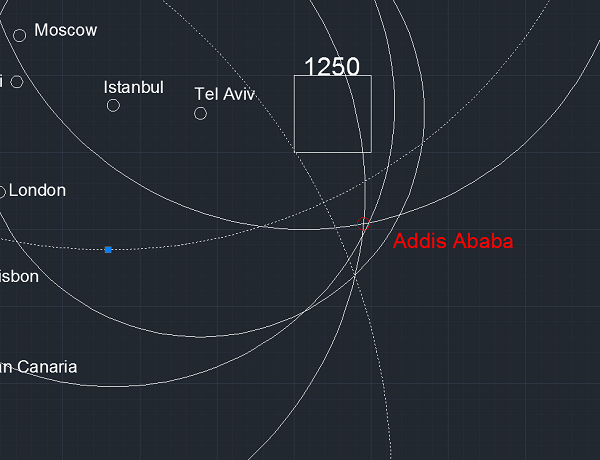
3 cities are perfectly intersects for Addis Ababa. These are New Delhi, Istanbul and London. One is close, it it Tel Aviv. NY circle stays outside of city and corrected. Two are close too but city has stayed outside of them.


As we know that, there is no problem if city stays inside of circles, but there is a problem if it stays outside. There is two city far to intersection: Sao Paolo and Beijing. So that, we'll try to move them through Addis Ababa a bit, but try to don't change other distances so much.

For this:

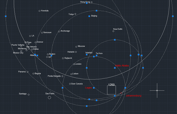
Tokyo, Beijing and Hong Kong moved through New Delhi as 400kms. (200kms agreed yet as map mistake. If we make more correction, maps general infrastructure map collapses). For saving distance between Delhi and Beijing, Delhi has moved to the south, 300kms. Santiago and Sao Paolo moved through right side together 400kms. For saving distance between Panama and Bogota, these two moved to same direction 200kms.

Hong Kong, Tokyo, New Delhi and Beijing together moved through Addis Ababa 225 kms, for create a perfect intersection. After that, for saving distance to Addis Ababa, Delhi rotated aroung Beijing 400 kms till enough to save distance with Addis Ababa. For saving distance with far Asia, Honolulu moved through Anchorage-Tokyo Line 500kms. For saving distance with Honolulu, Anchorage moved through opposite direction of Honolulu, 400kms.

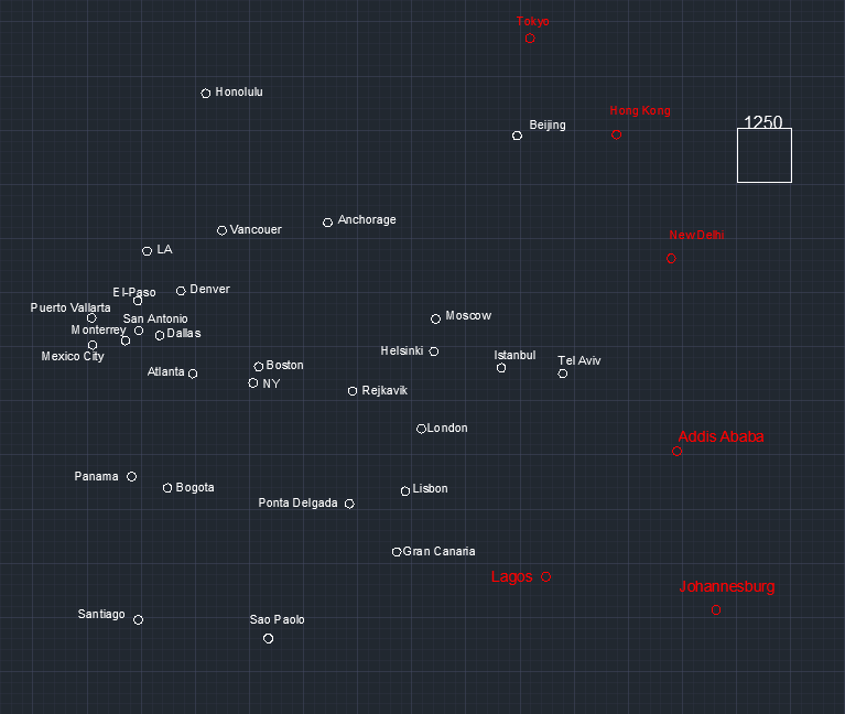
Addis Ababa is added as a perfect intersection point for whole world:


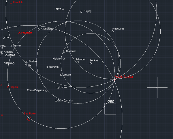
Addis Ababa, After Honolulu and Anchorage are moved.

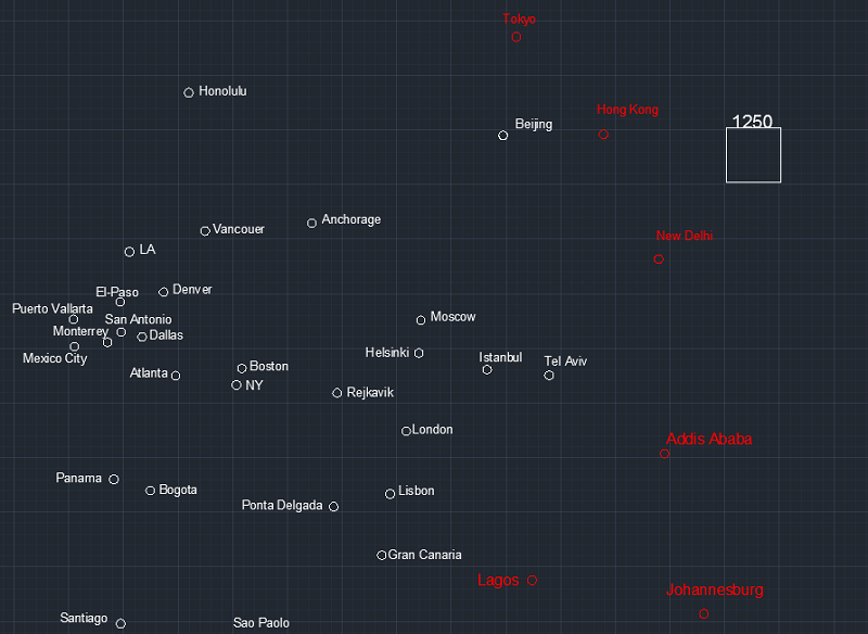
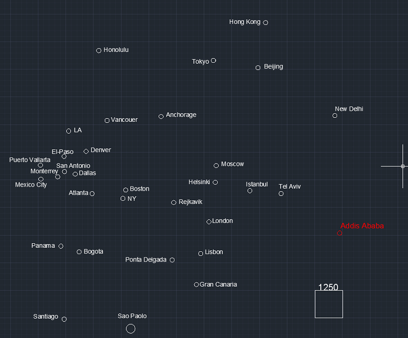
Addis Ababa is added as (about) east border of Africa:


Lagos:

Lagos Addis 3.921 4.194
Lagos Istanbul 4.589 5.215
Lagos London 5.010 5.177 (4963)
A346 5:38 881
B744 6:03 891
Lagos Atlanta 9.406


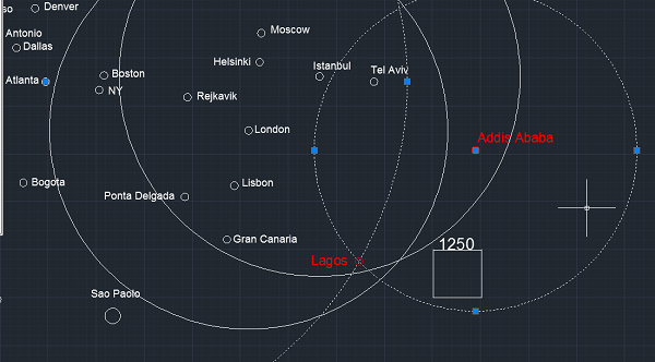
This time, nothing is changed and Logas is selected a point in intersection of Atlanta and Addis Ababa paths. There was a bit mistake seems remained but these are upper limits, it may be less than them . As we earlier said, to be inside is no problem, because everytime there is a possibility an aircraft runs better. On the other hand, there was only 4 reliable data and these was insufficient for create a reliable point. So perhaps, we may change that point soon. So that, Lagos is added as one of the eastern city in Africa:


Johannesburg

Johannesburg Addis 4.073 4.400
Johannesburg Lagos 4.530 4.885
5:40 862
Johannesburg Tel aviv 6.512 7.488 corrected as 7.166
8:37 869
Johannesburg Istanbul 7.471 8.039
9:17 866
Johannesburg London 9.086 9.252
10:10 910
Johannesburg Beijing 11.721 12.056
13:30 893
Johannesburg Hong Kong 10.686 11.212
12:20 893
12:50 889
Johannesburg Atlanta 13.597 13.452
14:45 912
Johannesburg NY 12.845 12.934
14:30 892
Johannesburg Sao 7.447  8.195 (7.430 , 8.959) will not affect to create point. (suspicious flights)
8:33 869
10:15 874

A point is selected for Johannesburg:


This point is near or on the intersections of Addis, Lagos, Istanbul, Tel Aviv, London, Beijing, Atlanta and NY.

There is two handicaps remained: Hong Kong and Sao Paolo.

Sao Paolo will not changed yet, because here is some suspicious flights between those cities. We'll return it later.

Now, Hong Kong. On ball map, Hong Kong is in the south west of the Beijing. And the last calculations show Hong Kong not at there and must be wes side of Beijing.

So that,

Hong Kong, Beijing and Tokyo should be corrected, accordingly to themselves.

1- Hong Kong deleted.
2- Hong Kong re-placed to the map as follow:


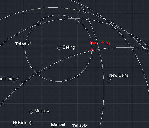
Hong Kong is moved to the intersection points of Johannesburg and Beijing, with a radical decision. This point is inside of all circles defines Hong Kong. Hong Kong is ok now.

New Delhi re-placed accordingly with Hong Kong.

Although it was a perfect intersection, Beijing moved to Johannesburg 200kms. Tokyo re placed.

Distances are generally overlaps. Also NY and London distances perfectly overlaps in Tokyo. There is only a gap with LA-Tokyo distance. On our map, it is 10.120 kms but in theorically it should be 9.000kms. Our value is 1.000kms more than aour calculations. I'm trying to solve this problem.


Anyway. There is just 1.000kms difference remained.


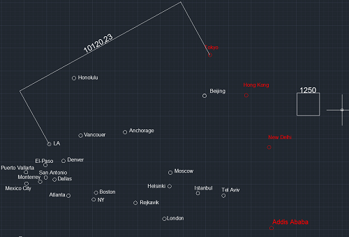
For now, I'll do nothing for this issue.

As a result, Addis Ababa, Lagos and Johannesburg are added and cities in far Asia are corrected.

He (somebody) is a troll homo playing role of girl.

(Look at the date)

WERERPC LEVEL2

NIGHT ENDS IN (ESTIMATED):


*

wise

  • Professor
  • Flat Earth Scientist
  • 30124
  • +135/-102
  • The Only Yang Scholar in Ying Universe
Re: Let's make a map all together depend on flight times
« Reply #220 on: January 23, 2018, 01:26:44 AM »
I'll focus on the center next a few days, in the aim of solve the 1.000kms difference problem of Tokyo to LA. (9.000 vs 10.000kms). Meanwhile we should understand whats the real view of the center. Meanwhile we may add Australia as a hat of the earth.  ;D

In this regard, Honolulu may change accordingly the relationship with Australia. Jakarta and whole Indonesia will be added.

It seems only a feew jobs are remained.
He (somebody) is a troll homo playing role of girl.

(Look at the date)

WERERPC LEVEL2

NIGHT ENDS IN (ESTIMATED):


*

wise

  • Professor
  • Flat Earth Scientist
  • 30124
  • +135/-102
  • The Only Yang Scholar in Ying Universe
Re: Let's make a map all together depend on flight times
« Reply #221 on: January 23, 2018, 04:35:14 AM »
Sydney
Sydney New Delhi 10.447 11.211
12:20 909
Sydney Beijing 8.975 9.116
10:34 869
10:08 893
Sydney Tokyo 7.827 8.212
9:00 899
9:10 909
Sydney Honolulu 8.180 8.140 %3,5 time correctance: 7.936
9:25 869
9:01 896
9:10 890
Sydney LA 12.075 11.945 best 11.401
12:46 893
13:25 902
13:22 912
13:26 874
13:25 916
Sydney Vancouer 12.516  12.150 3,5% correctance: 11.800
Sydney Johannesburg 11.036

After a bit working, it is understood that "Johannesburg-Sydney" flight completely a hoax.

For be sure it is a hoax, I searched for an online ticket company and request that flight:


Site searched in over 1.000.000 flights and could not offer me a direct flight.

For you better understand the issue, I want to show you the sittuatin in diagram:

Here is all of the circles gets inside the city of Sydney, except Johannesburg.


If we take a better look, there is some mentality mistakes of existance of this route. Because after tousends of examine, I never saw a difference like that.

If the distance was stay like this, it was meaningfull, and classic:


We can correct this mistake by a bit rotate, bring closer, etc. But this difference tecnically impossible:


This is a hoax. And flight site is saying me this flight doesn't exist, after I gave them my master card knowledges for buy it. ;)

So;

According to these determination, Sydneys placed in the intersection point of New Delhi and LA; on the other hand inside of the circles of Beijing and Tokyo. Tokyo distance was about 7.000 and we showed it as 5.200kms. This is fair enough for represant the maximum mistakes on the map.

I also searched for a flight between Sydney and Santiago for "buy".


Site examined after 1.000.00 flights then offered me "no direct fly" but some indirect flights.

I wonder is it Sao Paolo and Johannesburg flight exist?

Site examined more than 677.000 flights and offered me a direct line from Sao to Johannesburg:


After that, I decided Sao to Johannesburg path is exist. I already placed them on the places that possible to travel between themselves:


So who says to travel between these cities: "Santiago-Sydney or opposite; Sydney to Johannesburg or opposite" says lie. Clearly lie. Who says it, he is the biggest dishonest liar in the world.
He (somebody) is a troll homo playing role of girl.

(Look at the date)

WERERPC LEVEL2

NIGHT ENDS IN (ESTIMATED):


*

wise

  • Professor
  • Flat Earth Scientist
  • 30124
  • +135/-102
  • The Only Yang Scholar in Ying Universe
Re: Let's make a map all together depend on flight times
« Reply #222 on: January 24, 2018, 12:57:06 AM »
Singapore (SIN)

We'll add this city for control the relationship with whole world  and the Ocenia.

Meanwhile, this will be work for understand did we placed Sydney correctly, or not.

Singapore   Sydney 6.302 6.886
7:34 910
Singapore   Tokyo 5.306 5.328 (3,5%less = 5.194)
6:00 888
Singapore   Hong Kong 2.569 2.922
3:17 890
Singapore   Beijing 4.495 5.089
5:45 885
Singapore   LA 14.118 13.133
14:24 912
Singapore   Addis 7.267 8.636
9:30 909
Singapore   Johannesburg 8.666 9.286
10:17 903
Singapore   Istanbul 8.678 8.841
9:54 893
Singapore   London 10.895 11.104
12:20 893
Singapore   Helsinki 9.286 10.610
11:45 903
Singapore Delhi 4.163

Singapore is selected as an intersection points of 5 cities:

Sydney, Beijing, Istanbul, Los Angeles and and London.


First we see that Sydney is well placed on the map and intersects with the whole map. So we need some corrections on other cities except these 5 ones.

For understand the directions well, we'll placed the "MAGNETIC POLE CENTER" on the map as an estimation. We know it is north of the Anchorage, Moscow, Beijing and whole USA.

For a better estimation I drawed these two lines, seem their opposite sides: Moscow to Anchorage, Beijing to a place a few east of NY.


Now. there is magnetic center of the earth as N. There is two yellow lines are estimated new places for Tokyo and Hong Kong. These places overlaps with their magnetic places; Tokyo should be placed to east of the Beijing and with a few South; Hong Kong swhould be south of the Beijing with a few west. Beijing is well placed so these two cities are turned around Beijing till find the perfect point for them:


These points about overlaps with new point of Singapore; meanwhile corrects their real places.

Now we should correct the place of New Delhi accordingly to them:

Hong Kong moved about 1.700kms and there is distance New Delhi's circle to intersection 1.400 kms. So we'll move New Delhi through Singapore 1.400kms. This will correct both distances with Tokyo, Hong Kong and Singapore.


New Delhi problem is solved. Now there is a problem occurred between New Delhi and Addis Ababa about 1.460kms. This distance is same with the difference Addis Ababa circle to Singapore. So if we move Addis Ababa through New Deldi 1.460kms, problem will be solved:


Now we solved all the problems  except Johannesburg and related problems:

First I draw a circle around  Lagos for stay connected the distance with Johannesburg. Now Johannesburg will move on this circle through New Delhi 1.460kms. This move mistakes no other correction on whole map:


Now we should make an error distribution for these cities: Johannesburg, New Delhi, Addis and Lagos.

We must move Johannesburg to Singapore, 3.000kms more. And as an error distribution, Addis to New Delhi 2.000, and New Delhi to Singapore 1.000kms will be moved. The changing with Lagos will be measured and Lagos will moved accordignly with its partners. Lets do it:


Now Johannesburg perfectly overlaps with Singapore; there is 1.350 kms difference occurred with Lagos; New Delhi moved through Hong Kong about 500kms.

It doesn't seem a problem with whole map, except Lagos side.

Lagos was already a weak point, only had 4-5 connections to other cities. Lagos re placed, All mistakes are corrected.

As a result;

- Singapore is added and some corrections are made.

- Magnetic center of the earth is added.

He (somebody) is a troll homo playing role of girl.

(Look at the date)

WERERPC LEVEL2

NIGHT ENDS IN (ESTIMATED):


*

wise

  • Professor
  • Flat Earth Scientist
  • 30124
  • +135/-102
  • The Only Yang Scholar in Ying Universe
Re: Let's make a map all together depend on flight times
« Reply #223 on: January 24, 2018, 03:18:16 AM »
"Hot line" is added. Center of the earth is re-placed.


We have 14 circles represant the equator line. 9/14 cities are perfectly overlaps with this line. The remain ones nedd to be examined:

Sao Paolo and Santiago: Sao Paolo seems out of the circle (southern side). Although it seems closer to the "hot line", at least it is out with hot line with Santiago. No correction is made.
Sydney: Seems in the southern side of the hot line. Although it seems closer to the hot line, but we don't know real hot line on globe map been true or not. So this place is fair enough.
New Delhi: Our map shows Delhi should be placed more north*. This is relevant with real India is greater than shown in the ball map. So actually this place is perfectly true.
Addis Ababa and Johannesburg: Johannesburg seems on the hot line and Addis Ababa seems in the Northern semicircle. This should be corrected. As I examined that, Luanda line may be accepted as hot line. It is about 1.000 kms North of the Johannesburg. So Johannesburg, with Addis Ababa moved through South 1.000kms as an "hot line correction"


*corrected
He (somebody) is a troll homo playing role of girl.

(Look at the date)

WERERPC LEVEL2

NIGHT ENDS IN (ESTIMATED):


*

wise

  • Professor
  • Flat Earth Scientist
  • 30124
  • +135/-102
  • The Only Yang Scholar in Ying Universe
Re: Let's make a map all together depend on flight times
« Reply #224 on: January 24, 2018, 03:26:38 AM »
After all corrections, unusual circles and lines are deleted. As a newly, Singapore, center of the earth and hot line remained as new. Hot line and center will be visible in whole working hereafter:

He (somebody) is a troll homo playing role of girl.

(Look at the date)

WERERPC LEVEL2

NIGHT ENDS IN (ESTIMATED):


*

wise

  • Professor
  • Flat Earth Scientist
  • 30124
  • +135/-102
  • The Only Yang Scholar in Ying Universe
Re: Let's make a map all together depend on flight times
« Reply #225 on: January 24, 2018, 04:32:05 AM »
Jakarta

Jakarta   Istanbul 9.456 10.106
11:19 893
Jakarta   London 11.734 12.279
13:45 893
Jakarta   Beijing 5.243 5.731
6:38 864
Jakarta   Tokyo 5.791 6.080
6:44 903
Jakarta   Hong Kong 3.263 3.938
4:45 862
4:25 856
Jakarta   Sydney 5.525 5.782
6:42 863
Jakarta   Singapore 883 997
1:18 734
1:30 772
1:11 743

Placing the Jakarta:


5/7 cities are corrected. Only 2 remained. Singapore moved 157kms and Sydney 1.547kms moved through Jakarta. Whole distances are corrected:


Control:

If you constantly go from Sydney to North, you pass a direction near to Tokyo. Tokyo a bit remains west of you. This is ok. If you constantly go from Jakarta to constantly North, you pass somewhere near Singapore, Hong Kong and Beijing. There seem a bit mistake.


A line is drawn between N and Jakarta.
Singapore should be 400kms west. Its in the line. Singapore moved 400kms to the west.
Hong Kong should be 700kms east of the line. Its now 330kms. Hong Kong moved 370kms to the east.
Beijing is 700kms east of the line. On map, on the line. But we know that China in fact is bigger than shown in the map. So it will not changed. Beijing is in the north of Jakarta.

Sydney is moved to the south west as 500kms.

After Jakarta is placed, Singapore, Hong Kong and Sydney corrected.

He (somebody) is a troll homo playing role of girl.

(Look at the date)

WERERPC LEVEL2

NIGHT ENDS IN (ESTIMATED):


*

rvlvr

  • 2148
  • +0/-0
Re: Let's make a map all together depend on flight times
« Reply #226 on: January 24, 2018, 04:47:18 AM »
Again, I am not so sure what to make of all this. What are the key findings, what differs from what I've been taught?

*

wise

  • Professor
  • Flat Earth Scientist
  • 30124
  • +135/-102
  • The Only Yang Scholar in Ying Universe
Re: Let's make a map all together depend on flight times
« Reply #227 on: January 24, 2018, 05:22:18 AM »
Manila

Manila Jakarta 2.791 3.365
3:57 852
Manila Singapore 2.378 2.873
3:25 841
Manila Hong Kong 1146 1.393
1:48 774
Manila Beijing 2.880 3.284
3:51 853
Manila Tokyo 3000 3.278 corrected as 2.861
3:49 852
3:40 901
Manila Sydney 6.271 6.494
7:31 864
Manila Istanbul 9.147 9.600 Corrected as 8.623
10:45 893
Manila LA 11.753 10.746 corrected as 11.252
12:02 893
Manila Honolulu 8.530 7.821
9:00 869


Manila is perfectly matched with 8/9 cities. Also LA, Istanbul and Honolulu overlapped!

Only Sydney could not be overlapped. Qantas airlines running in this path. But we know that Qantas (satanq) airlines going imaginary flights so that they are going on wrong path to Manila. So that, we don't correct this mistake. But it is already in the circle. This means, according to distance to Sydney, if aircrafts are going wrong and making the path longer, this place is possible.

No correction requered. Idiot Aussies goes further (about 2 times more). This is their problem.  8)


Manila is placed perfectly.

He (somebody) is a troll homo playing role of girl.

(Look at the date)

WERERPC LEVEL2

NIGHT ENDS IN (ESTIMATED):


*

wise

  • Professor
  • Flat Earth Scientist
  • 30124
  • +135/-102
  • The Only Yang Scholar in Ying Universe
Re: Let's make a map all together depend on flight times
« Reply #228 on: January 24, 2018, 05:25:10 AM »
Again, I am not so sure what to make of all this. What are the key findings, what differs from what I've been taught?

Good.
He (somebody) is a troll homo playing role of girl.

(Look at the date)

WERERPC LEVEL2

NIGHT ENDS IN (ESTIMATED):


*

wise

  • Professor
  • Flat Earth Scientist
  • 30124
  • +135/-102
  • The Only Yang Scholar in Ying Universe
Re: Let's make a map all together depend on flight times
« Reply #229 on: January 24, 2018, 05:54:31 AM »
Port Moresby

Port Moresby   Manila 3.934
Port Moresby   Singapore 4.941
Port Moresby   Hong Kong 5.069 5.504
6:20 869
Port Moresby   Tokyo 5.084
Port Moresby   Sydney 2.758 2.961
3:32 838

Port Moresby is added as a point near to intersections and inside all of circles. Sydney moved through south 1.000kms, because of Qantas pilots could not dishonest so much like that. They only make an understandable mistake.


As we see that this time Sydney passangers are lucky. Because they fly with Air Niugini this time. Honored Air Niugini doesen't make your dreams to reality but doesn't bamboozle you!

Port Moresby is about in the north of the Sydney but our map in about east. How is it possible?

Lets control it by a magnetic map:


Port Moresby is in the "West-North-West".

In our map Port Moresby is in the "West-North-West". Corrected. Gang is deceiving Aussies in the matter of Port Moresby.

(Port Moresby actually is in the North but your compasses show them in the west. Don't trust compass but the GANG).  ;D

Anyway.

After Port Moresby is added its true place; West North-west of the Sydney!

« Last Edit: January 24, 2018, 06:01:36 AM by brotherhood of the dome »
He (somebody) is a troll homo playing role of girl.

(Look at the date)

WERERPC LEVEL2

NIGHT ENDS IN (ESTIMATED):


?

Antonio

  • 379
  • +0/-0
Re: Let's make a map all together depend on flight times
« Reply #230 on: January 24, 2018, 06:53:23 AM »
It would be interesting to add Auckland too, it's near Sydney

?

SpaceCadet

  • 466
  • +0/-0
Re: Let's make a map all together depend on flight times
« Reply #231 on: January 24, 2018, 07:42:44 AM »
Quote


I like your doggedness in this matter. You seem to be the only flat earther doing some research outside of youtube.

Help me understand. Is this, according to your calculations, and actual representation of the factual positions of these cities? Or are you expecting to still make more modifications as you make more calculations?
« Last Edit: January 24, 2018, 07:45:04 AM by SpaceCadet »

*

wise

  • Professor
  • Flat Earth Scientist
  • 30124
  • +135/-102
  • The Only Yang Scholar in Ying Universe
Re: Let's make a map all together depend on flight times
« Reply #232 on: January 24, 2018, 11:16:45 AM »
It would be interesting to add Auckland too, it's near Sydney

Hard part is already done. Whole cities are easier.
He (somebody) is a troll homo playing role of girl.

(Look at the date)

WERERPC LEVEL2

NIGHT ENDS IN (ESTIMATED):


?

Antonio

  • 379
  • +0/-0
Re: Let's make a map all together depend on flight times
« Reply #233 on: January 24, 2018, 11:03:43 PM »
You really should look at Auckland. It has strong connections with South America, Asia North America and Australia. It may help to locate Australia.

*

wise

  • Professor
  • Flat Earth Scientist
  • 30124
  • +135/-102
  • The Only Yang Scholar in Ying Universe
Re: Let's make a map all together depend on flight times
« Reply #234 on: January 24, 2018, 11:20:44 PM »
Cairns (North West* Australia)

Cairns Sydney 1974 2.203
2:42 836
2:35 832
Cairns Port Moresby 843 822
1:06 747
Cairns Singapore 5.013 5.741 corrected as 5.351
6:35 872 5.741
Cairns Hong Kong 5.575 6.566 corrected as 5.676
7:36 864
Cairns Tokyo 5.889 6.384 *proved 6.384
7:00 912


3 cities are overlaps in one point but the most important one  doesn't overlap. Port Moresby should move through intersection point. Other distances are controlled, no problem occurs. Manila-Port Moresby distance is 1.000kms longer than shown in our map. So it is fair enough the move it 900kms south.

Port Moresby moved through intersection point 890kms and Cairns is added perfectly as  the intersection point of 5 cities:


There is two points getting our interest:

1- Cairns is in the "west-south west" of the sydney. On ball map, it is in about North.
2- Port Moresby is in the directly west of Sydney. In ball map, it is about directly North.

Remember why this mistake occurred in google and other ball headed maps:


They are deceiving people by this way. Dishonored ones!

Anyway, this is not aour job.


Cairns is aded as a "perfect and strong point", with a correction to Port Moresby.
He (somebody) is a troll homo playing role of girl.

(Look at the date)

WERERPC LEVEL2

NIGHT ENDS IN (ESTIMATED):


*

wise

  • Professor
  • Flat Earth Scientist
  • 30124
  • +135/-102
  • The Only Yang Scholar in Ying Universe
Re: Let's make a map all together depend on flight times
« Reply #235 on: January 24, 2018, 11:22:04 PM »
You really should look at Auckland. It has strong connections with South America, Asia North America and Australia. It may help to locate Australia.

I'll already do it. But as a methodically it is not ready to be done yet. In this method, I should become closer it for make it. How many connected points be more, in this case it will be a stronger point.
He (somebody) is a troll homo playing role of girl.

(Look at the date)

WERERPC LEVEL2

NIGHT ENDS IN (ESTIMATED):


?

Antonio

  • 379
  • +0/-0
Re: Let's make a map all together depend on flight times
« Reply #236 on: January 24, 2018, 11:40:09 PM »
I'm sorry, but i don't understand your sentences. Anyways, do you agree that you need about  3h30 to get from Auckland to Sydney ?

*

wise

  • Professor
  • Flat Earth Scientist
  • 30124
  • +135/-102
  • The Only Yang Scholar in Ying Universe
Re: Let's make a map all together depend on flight times
« Reply #237 on: January 25, 2018, 12:23:27 AM »
Denpasar (Indonesia)

I know most of Indonesians wonder where is Denpasar?

Google, yandex, NASA and whole others are deceiving you, Indonesians but I'm not doing this. Because I have no advantage for this.

Denpasar   Port Moresy 3.523 3.708 corrected as 2.750
4:23 846
Denpasar   Cairns 3.437 3.665 corrected as 3.395
4:20 846
Denpasar   Sydney 4.628 4.751
5:39 A333 862 4.780
5:31 B738 856 4.722
Denpasar   Jakarta 983 1.011
1:21 A320 765
1:18 B738 760
Denpasar   Singapore 1.674 1.994 corrected as 1.730
2:24 A333 818
2:22 B77w 855
Denpasar   Manila 2.700 3.059 corrected as 2.658
A320 3:43 843
Denpasar   Hong Kong 3.460 3.983 corrected as 3.277
A333 4:29 862
B77w 4:38 885
Denpasar   Beijing 5.437 5.506
6:12 B773 888
Denpasar   Tokyo 5.617 5.674
6:34 A330 864

Placing Bali's capital; Denpasar:

There is an aerodrome traffic density in marked place.


This place is inside of 7/9 measurements and two are near but out of it: Sydney and Jakarta.

There is 646 kms mistake.

So that,

Sydney group (Sydney, Port Moresby and cairns) moved through intersection 323 kms as a block; and Jakarta moved through intersection point 323 kms. For saving distance with Singapore, Jakarta turned around Singapore. Singapore doesn't changed because it is well placed. Also Tokyo and Beijing perfectly overlaps with this point:


As a result, Denpasar is added as another perfect point in the map. We may say easily that, it is definitely stay this point!

He (somebody) is a troll homo playing role of girl.

(Look at the date)

WERERPC LEVEL2

NIGHT ENDS IN (ESTIMATED):


*

wise

  • Professor
  • Flat Earth Scientist
  • 30124
  • +135/-102
  • The Only Yang Scholar in Ying Universe
Re: Let's make a map all together depend on flight times
« Reply #238 on: January 25, 2018, 12:37:35 AM »
Perth

Surely, where is Perth. This city works for us understand the real shape, size and true direction of Australia. We are making free the Aussies from the lies of  NASA, google, yandex and whole deceivers.

After listen a song, I'll do that:

He (somebody) is a troll homo playing role of girl.

(Look at the date)

WERERPC LEVEL2

NIGHT ENDS IN (ESTIMATED):


*

wise

  • Professor
  • Flat Earth Scientist
  • 30124
  • +135/-102
  • The Only Yang Scholar in Ying Universe
Re: Let's make a map all together depend on flight times
« Reply #239 on: January 25, 2018, 02:36:16 AM »
Perth

Perth Cairns 3.435 3.749
A320 4:24 852
Perth Sydney 3.282 3.393
4:04 A320 852
3:56 A332 862
3:55 B738 856
Perth Denpasar 2.584
B739 3:14
A320 3:20
Qantas flights are ignored from now on; because I believe about them provide wrong knowledge.
Perth Jakarta 3.032 3.395
3:58 B738 856
Perth Singapore 3.915 4.093
4:40 A320 852
4:55 B738 856

Perth Hong Kong 6.043 6.453
A333 7:20 864
A359 7:19 898

Placing the Perth:

Sydney is moved accordingly saving distance with Tokyo; about 2.000kms to south. Cairns re placed. Others don't changed and Perth is placed with a great success!


Perth is worked for us understand the true shape and direction of Australia and true place of Sydney. It seems more meaningfull now.

Now we are doing another operation now. Its now or never: Correctance with distance Sydney-LA; and Sydney Honolulu.


1- This group selected and turned all together around N (center) till our error limit for New Delhi finishes and that part overlaps:

2- Now we arrived the perfect match in African side. Other side a bit corrected:


The right green circle represant the distance between Delhi and Addis Ababa. And this distance is corrected now. On the other hand, we need more 2.200kms rotate for correcting the Sydney-LA/Honolulu distances.

Drawing circles from New Delhi to Beijing, Hong Kong and Singapore.


3- Now. We are holding New Delhi on its place, because it is already corrected. These two marked circles represant distances from New Delhi to Beijing and Singapore. We have a right to touch this circles until we turn around N (center. Lets do it.


The gap of Singapore is filled but Beijing is remain. Now we'll move  same cities a more, accordingly saving distance to New Delhi.

This time we are rotating them around N again.


Now. 589 kms remained. We used cities till Singapore, Beijing and Hong Kong line.

Now we'll hold these 3 cities as stable, and try to move remained Ocenian cities:


Touched.

Now all distances are corrected with Sydney from Africa and Europe to Asia and North America.


Perth is added with some corrections on whole map.
He (somebody) is a troll homo playing role of girl.

(Look at the date)

WERERPC LEVEL2

NIGHT ENDS IN (ESTIMATED):