The world's most accurate map

  • 376 Replies
  • 73761 Views
*

wise

  • Professor
  • Flat Earth Scientist
  • 25446
  • The Only Yang Scholar in The Ying Universe
Re: Let's make a map all together depend on flight times
« Reply #150 on: January 16, 2018, 05:53:10 AM »
Gran Canaria

Gran Canaria-Rejkavik 4.047 4.703
A321 5:26 853 4.635
B738 5:34 857 4.771

Gran Canaria-Lisbon 1.339 1.563
E190 (equal to B738) 1:59 788

Gran Canaria-London 2.904 3.243
A320 3:50 846

Gran Canaria-Ponta Delgada 1.456 1.733
DH8D (equal to A319) 800 2:10

Added Gran Canaria in the aim of preparing the center.

1+2+3+...+∞= 1

Come on bro, just admit that the the earth isn't a sphere, you won't even be wrong

*

Macarios

  • 2093
Re: Let's make a map all together depend on flight times
« Reply #151 on: January 16, 2018, 06:03:44 AM »
I do not quite get why the route is fraudulent?

All routes in southern hemisphere are "fraud" because they ruin their "proof" of the Earth to be "flat".
Standard FE "logic".
He already discarded all flights between Australia, South America and Africa because he doesn't like them.
Buenos Aires - Johannesburg, Antananarivo - Perth, Wellington - Santiago, Wellington - Lima, and more...

For now he's limited to northern hemisphere, to buy some time until he decides what to do with south.
I don't have to fight about anything.
These things are not about me.
When one points facts out, they speak for themselves.
The main goal in all that is simplicity.

*

rvlvr

  • 2148
Re: Let's make a map all together depend on flight times
« Reply #152 on: January 16, 2018, 06:14:15 AM »
Oh, okay.

Thanks!

*

wise

  • Professor
  • Flat Earth Scientist
  • 25446
  • The Only Yang Scholar in The Ying Universe
Re: Let's make a map all together depend on flight times
« Reply #153 on: January 16, 2018, 10:33:55 AM »
I like smart enemies but ignoring stupid ones. I can not enjoy the easy winning victories. I already made a map and it is already done. If you make a bit search, you can find that I already solved the problems you talk about. But I'm going to more excited victory. This is my fun.  8)
1+2+3+...+∞= 1

Come on bro, just admit that the the earth isn't a sphere, you won't even be wrong

*

Macarios

  • 2093
Re: Let's make a map all together depend on flight times
« Reply #154 on: January 16, 2018, 10:40:12 AM »
 :(
I like smart enemies but ignoring stupid ones. I can not enjoy the easy winning victories. I already made a map and it is already done. If you make a bit search, you can find that I already solved the problems you talk about. But I'm going to more excited victory. This is my fun.  8)

hehehe

I wonder how you solved the problem of ground speed of subsolar point.
(What is the shape of the part between Tropic of Cancer and Tropic of Capricorn.)

Longitudinal (east-west) distances there are easy to measure that way.
North-south distances are the same on flat and globe maps anyway.
I don't have to fight about anything.
These things are not about me.
When one points facts out, they speak for themselves.
The main goal in all that is simplicity.

*

wise

  • Professor
  • Flat Earth Scientist
  • 25446
  • The Only Yang Scholar in The Ying Universe
Re: Let's make a map all together depend on flight times
« Reply #155 on: January 16, 2018, 11:17:53 PM »
:(
I like smart enemies but ignoring stupid ones. I can not enjoy the easy winning victories. I already made a map and it is already done. If you make a bit search, you can find that I already solved the problems you talk about. But I'm going to more excited victory. This is my fun.  8)

hehehe

I wonder how you solved the problem of ground speed of subsolar point.
(What is the shape of the part between Tropic of Cancer and Tropic of Capricorn.)

Longitudinal (east-west) distances there are easy to measure that way.
North-south distances are the same on flat and globe maps anyway.

They are not middle of the earth. Oppositely, they are almost outside of the earth. For example, where  does Chile stay? Surely, it is about the furthest point to the center. It does almost arrives to the Antarctica. On the other hand, the center isin't big like that and first 5 latitudes aren't exist. This events make the earth smaller. The earth is not bigger like that but if you want to travel between this cities, you draw a miningless route but not a circle or elips. They are places that have no special features. Can you claim that Sahara desert and Bahamas have same air conditions? Are they really? No, they aren't. Tropics just a hoax, they mean nothing, like whole world.
1+2+3+...+∞= 1

Come on bro, just admit that the the earth isn't a sphere, you won't even be wrong

*

Macarios

  • 2093
Re: Let's make a map all together depend on flight times
« Reply #156 on: January 16, 2018, 11:41:56 PM »
:(
I like smart enemies but ignoring stupid ones. I can not enjoy the easy winning victories. I already made a map and it is already done. If you make a bit search, you can find that I already solved the problems you talk about. But I'm going to more excited victory. This is my fun.  8)

hehehe

I wonder how you solved the problem of ground speed of subsolar point.
(What is the shape of the part between Tropic of Cancer and Tropic of Capricorn.)

Longitudinal (east-west) distances there are easy to measure that way.
North-south distances are the same on flat and globe maps anyway.

They are not middle of the earth. Oppositely, they are almost outside of the earth. For example, where  does Chile stay? Surely, it is about the furthest point to the center. It does almost arrives to the Antarctica. On the other hand, the center isin't big like that and first 5 latitudes aren't exist. This events make the earth smaller. The earth is not bigger like that but if you want to travel between this cities, you draw a miningless route but not a circle or elips. They are places that have no special features. Can you claim that Sahara desert and Bahamas have same air conditions? Are they really? No, they aren't. Tropics just a hoax, they mean nothing, like whole world.

Chile is not in the tropical area. Argentima neither, nor Madagascar. South of Australia is also out of it, just as New Zealand.
Tropical Area is where projection of the Sun gives accurate measurements, more accurate than flight times because Sun ALWAYS travels 15 degrees per hour.
Direct measurements in real world (real life).
At Equator ground speed of subsolar point is highest, and in both directions (to the north and to the south) that speed gets lower.
It directly gives BOTH tropics (Tropic of Cancer and Tropic of Capricotn) to have circumferences smaller that Equator.
What does it have to do with "Chile is not here or there" ?
« Last Edit: January 16, 2018, 11:43:30 PM by Macarios »
I don't have to fight about anything.
These things are not about me.
When one points facts out, they speak for themselves.
The main goal in all that is simplicity.

*

wise

  • Professor
  • Flat Earth Scientist
  • 25446
  • The Only Yang Scholar in The Ying Universe
Re: Let's make a map all together depend on flight times
« Reply #157 on: January 16, 2018, 11:47:35 PM »
You are causing just waste of time.
1+2+3+...+∞= 1

Come on bro, just admit that the the earth isn't a sphere, you won't even be wrong

*

rvlvr

  • 2148
Re: Let's make a map all together depend on flight times
« Reply #158 on: January 16, 2018, 11:49:57 PM »
Brotherhood, you must be able to do better.

*

wise

  • Professor
  • Flat Earth Scientist
  • 25446
  • The Only Yang Scholar in The Ying Universe
Re: Let's make a map all together depend on flight times
« Reply #159 on: January 17, 2018, 12:05:32 AM »
Brotherhood, you must be able to do better.

I am bad, I am ok like this.
1+2+3+...+∞= 1

Come on bro, just admit that the the earth isn't a sphere, you won't even be wrong

*

rvlvr

  • 2148
Re: Let's make a map all together depend on flight times
« Reply #160 on: January 17, 2018, 12:07:21 AM »
Fair enough!

*

wise

  • Professor
  • Flat Earth Scientist
  • 25446
  • The Only Yang Scholar in The Ying Universe
Re: Let's make a map all together depend on flight times
« Reply #161 on: January 17, 2018, 12:39:43 AM »
Istanbul

Istanbul-Tel Aviv 1.135 1.465

B738 2:01 778
A321 1:46 774
A333 1:54 783
B77w 1:47 804

Istanbul-London 2.517 2.819
A321 3:07 837
A333 3:37 847
A320 3:19 837
B77w 3:15 870

Istanbul-Moscow 1.872 1.952
A320/321 2:23

Istanbul-Lisbon 3.226 3.715
B738 4:22 856
A321 4:20 852

Istanbul-NY 8.062  7.267
B77w 8:14 892
A333 8:17 868

Istanbul-Atlanta 9.282 8.647
A332 9:57 869

Istanbul-Beijing 7.078 7.767
B77w 8:43 891

Stage of working. Istanbul should be inside all of these circles:


Sure we can:


This point fully overlaps with the intersection of: Lisbon, Tel Aviv and Moscow.And stays inside of whole cities.

If the earth was not flat, how was it perfectly overlap like this.

Last version of map:


Istanbul is added as center of the universe.  :)
1+2+3+...+∞= 1

Come on bro, just admit that the the earth isn't a sphere, you won't even be wrong

*

rvlvr

  • 2148
Re: Let's make a map all together depend on flight times
« Reply #162 on: January 17, 2018, 12:44:41 AM »
"Istanbul is added as center of the universe.  :)"

That I am willing to believe!

*

wise

  • Professor
  • Flat Earth Scientist
  • 25446
  • The Only Yang Scholar in The Ying Universe
Re: Let's make a map all together depend on flight times
« Reply #163 on: January 17, 2018, 12:47:10 AM »
"Istanbul is added as center of the universe.  :)"

That I am willing to believe!

If you don't believe it, so you may measure!  ;D
1+2+3+...+∞= 1

Come on bro, just admit that the the earth isn't a sphere, you won't even be wrong

*

wise

  • Professor
  • Flat Earth Scientist
  • 25446
  • The Only Yang Scholar in The Ying Universe
Re: Let's make a map all together depend on flight times
« Reply #164 on: January 17, 2018, 01:27:58 AM »
New Delhi

We wonder so what happens if mountains prevent our intersections.  ???

New Delhi - Istanbul 4.563 4.849 (mountains???)
B77w 5:28 887

New Delhi - Tokyo 5.915  6.095 (mountains don't affect when aircrafts come from Tokyo)  ;)
B788/789 6:45 903

New Delhi - Beijing 3.813 4.669 (mountains start to affect if aircrafts come from Beijing, but not from Tokyo)  ;D
A333 862 5:25

New Delhi - Moscow 4.369  4.957
A332/333 5:45 862

New Delhi - London 6.739 6.983
B789 7:23  906
B77w 7:59  893
B772 7:54 881
B744 7:59 896

New Delhi - NY 11.768 11.396
B77w 12:44 895

I want to show you how these 6 so different routes perfectly matches.


On this drawing, New Delhi marked as the intersection point of 4 cities and 2 others are closer to them. One of the outside coming from NY and the other one Beijing. It is on intersection of London (far Europe), Moscow (Asia), Tokyo (far Asia) and Istanbul (middle east).

Added New Delhi as a perfect point. This proves how other cities well placed.

Used datas:

Istanbul   Tel aviv   1465
Istanbul   London   2819
Istanbul   Moscow   1952
Istanbul   Lisbon   3715
Istanbul   NY   7267
Istanbul   Atlanta   8647
Istanbul   Beijing   7767
      
New Delhi   Istanbul   4849
New Delhi   Tokyo   6095
New Delhi   Beijing   4669
New Delhi   Moscow   4957
New Delhi   London   6983
New Delhi   NY   11396

1+2+3+...+∞= 1

Come on bro, just admit that the the earth isn't a sphere, you won't even be wrong

*

wise

  • Professor
  • Flat Earth Scientist
  • 25446
  • The Only Yang Scholar in The Ying Universe
Re: Let's make a map all together depend on flight times
« Reply #165 on: January 17, 2018, 04:42:34 AM »
Hong Kong

Hong Kong - Istanbul 8.017 8.370
B77w 9:23 892

Hong Kong - Moscow 7.145 8.212
B77w 9:13 891

Hong Kong - London 9.642 10.125
B77w 11:30 893
B789 10:41 909
A388 11:26 909

Hong Kong - Tel Aviv 7.736 8.583
B772  10:11 882
A359  09:05 901

Hong Kong - Beijing 1.995 2.301
A320/321 2:40 825
A333 2:38 835
B738 3:01 830

Hong Kong - Tokyo 2.906 2.987
A321 3:25 848
B772 3:30 871
B788/789 3:25 896
B77w 3:28 881
B763 3:20 862

Hong Kong - Los Angeles 11.679  10.479
B77w 11:25 895
A359 11:52 905

Hong Kong - New York 12.984 13.007

B77w 14:32 895

Hong Kong - New Delhi 3.750 4.128
A333 4:48 862
B744 4:27 891
B788 4:33 901

Lets place it:


Anchorage (In the aim of fixing/stablizing the center of earth)

PANC-NY 5.441 5.417 (5.361)
B748 5:57 902
B744 6:07 892
B77L 6:01 902

PANC-LA 3.774 3.816
B737 4:59
B744 4:15 891
B748 4:16 901

PANC-Atlanta 5.495 5.241 (5159)
B744 5:47 892
B748 5:54 902

PANC-Beijing 8.6906.911 (flight site mistaken)
B763 873 7:55

PANC-Tokyo 5.521  5.325
B744 6:05 893
B748 5:48 903
B763 6:07 869

PANC-Hong Kong 8.175 7.661 (7.528)
B744 8:23 898
B748 8:35 908

Ok. Now lets create the center.


Used data for Anchorage, a bus stop of cargo companies.

PANC NY   5417   
PANC LA   3816   
PANC Atlanta   5541   
PANC Beijing   6911   
PANC Tokyo   5325   
PANC Hong Kong 8159   (corrected)


FINAL VERSION OF 17TH, JANUARY, 2018.

In this version, the place of Tokyo, Beijing and New Delhi updated (was rotated around the center and changed at least to its effect to be minimum) ; Hong Kong and Anchorage well placed.

With placing Anchorage, we'll achieved a chance to place as well as whole cities in America. This become our 4th reliable city in North America and these number of cities enough to detmine the others with minimum errors.

On the other hand, Hong Kong works for let us understand where should be the whole world. It is a connection point to a lot of places in whole world.
1+2+3+...+∞= 1

Come on bro, just admit that the the earth isn't a sphere, you won't even be wrong

*

Bullwinkle

  • The Elder Ones
  • 21053
  • Standard Idiot
Re: Let's make a map all together depend on flight times
« Reply #166 on: January 17, 2018, 05:22:14 AM »
On the other hand, Hong Kong works for let us understand where should be the whole world. It is a connection point to a lot of places in whole world.

Actually, Hong Kong is an outpost, not a hub.

http://flightroutes.geographica.gs/

Do you even have internet access?

*

wise

  • Professor
  • Flat Earth Scientist
  • 25446
  • The Only Yang Scholar in The Ying Universe
Re: Let's make a map all together depend on flight times
« Reply #167 on: January 17, 2018, 05:36:53 AM »
Denver

Denver-PANC 3.867 3.956
B738 4:37 857

Denver-NY 2.613 2.880 (2.772)
A321 3:18 840
A319 3:30 840
B738 3:23 852
B739 3:26 852

Denver-LA 1.387 1.603
A320 1:58 784
B737 2:05 779
A319 1:58 784
B712 2:03 775
B738 2:03 788
B739 2:10 788

Denver-Atlanta 1.928 2.044
A320 2:30 819
B737 2:20 814
B738 2:27 823
B739 2:38 823
B764 2:29 842

Denver-Tokyo 9.303 8.893
B788 9:47 909

Denver-London 7.504  7.355
B744 8:12 897

Denver-Rejkavik 5.734 5.483
B752 6:19 868

I marked the circles which intersect for show you how the map perfectly works and how Denver is absolutely at there:


Used data for placing the Denver:

Denver   PANC   3956
Denver   NY   2880
Denver   LA   1603
Denver   Atlanta   2044
Denver   Tokyo   8893
Denver   London   7355
Denver   Rejkavik   5483

Final image after placing Denver:


This is about 70% of whole world. They may say "hey where is south, where is the other part of the earth?". Perhaps. But there is no south or north, only a center. And these cities about more than half of the world.

You can ask any distances on the map, which you have a doubt.
1+2+3+...+∞= 1

Come on bro, just admit that the the earth isn't a sphere, you won't even be wrong

*

wise

  • Professor
  • Flat Earth Scientist
  • 25446
  • The Only Yang Scholar in The Ying Universe
Re: Let's make a map all together depend on flight times
« Reply #168 on: January 17, 2018, 05:42:18 AM »
Anchorage worked for fix the point of Denver. Denver is more and more stronger point according to Anchorage. Now we have very strong 4 points in USA:

Denver, NY, LA and Atlanta. I'm not thinking to use Boston. Actually I added Boston as an alternative to NY, because some flight companies fly to Boston instead of NY. Anyway.

These 4 cities are enough to find out every place in USA and whole continent of America; including Brasil and Chile.  ;)

This is tomorrows job. Soon...
1+2+3+...+∞= 1

Come on bro, just admit that the the earth isn't a sphere, you won't even be wrong

*

wise

  • Professor
  • Flat Earth Scientist
  • 25446
  • The Only Yang Scholar in The Ying Universe
Re: Let's make a map all together depend on flight times
« Reply #169 on: January 17, 2018, 05:57:10 AM »
The next goal is determining the remain Priority regions:

1- Hartsfield-Jackson Atlanta ...done
2- Dubai (3)
3- Los Angeles done...
4- Chicago (6) In a useless place.
5- London done...
6- Paris (10) In a useless place.
7- Dallas Fort Worth (11) **
8- Amsterdam (12)  **
9- Frankfurt (13) In a useless place.
10- Istanbul done...
11- New York done...
12- Denver done...

6 of important cities are done and 6 are remained. I'm not sure for that but thinking tomorrow stick on this issue.
« Last Edit: January 17, 2018, 09:41:12 PM by brotherhood of the dome »
1+2+3+...+∞= 1

Come on bro, just admit that the the earth isn't a sphere, you won't even be wrong

*

wise

  • Professor
  • Flat Earth Scientist
  • 25446
  • The Only Yang Scholar in The Ying Universe
Re: Let's make a map all together depend on flight times
« Reply #170 on: January 17, 2018, 11:44:16 PM »
Dallas

Dallas-NY 2.237 2.447 2.241
B738 3:09 836 2.633
B77L 2:33 879
B763 2:55 846

Dallas-LA 1.985 2.135
A319 2:39 825
A320 2:30 825
A321 2:41 825
B738 2:34 828
B763 2:25 838
B789 2:31 872

Dallas-Atlanta 1.176 1.356 1.200
A319 1:48 774
A320 1:48 774
B738 1:51 778
B748 1:28 818

Dallas-Denver  1.033 1.167
A306 1:14 781
A319 1:35 764
A320 1:31 764
A321 1:37 764
B738 1:39 768

Dallas-Tokyo 10.334 9.306
B772 10:17  885
B788 10:27  910

Dallas-Beijing 11.288 11.509
B788 911 12:38

Dallas-London 7.636 7.352
B744 8:04 897
B772 8:19 882
B773 8:22 891
B77w 8:17 891

Numerous workings prove that London is closer to USA than shown in the ball/fake maps.

Dallas is added another "perfect point" in USA, after Denver placed.


In this diagram, circle intersections how how Dallas true placed. These are 7 circles some of them coming from 10.000kms above and perfectly intersect in same point. I took all values as we calculated, just Beijing decreased 11.509 to 11.141 (google 11.288) and Tokyo increased from 9.306 to 9.958 kms (google  10.334). Google values still wrong but our differences decreased a bit for just these two cities. Others perfectly overlaps. On the other hand, 11.509 to 11.141 changing means 3% correction.

The time passing the USA-Mexico border.  ;)

El Paso

El Paso-Los Angeles 1.148 1.269
B737 2:01 769

El Paso- Denver 909 1.040
Various unknown type 1:21 770 1.040

El Paso- Atlanta 2.061 2.145
A320 2:36 825

El Paso- Dallas 887 1.191
B738 1:34 760

Version of 18.01.2018, Dallas and El-Paso is added.


I chosed San Antonia, instead of Houston; because San means Saint is a good thing but Houston is a liar.  ;D

San Antonio

San Antonio Dallas 398 531
A321 0:56 578
B738 0:54 581

San Antonio Atlanta 1.406 1.607
B737 1:55 790
B738 2:06 800
B739 2:02 800

San Antonio Denver 1.282 1.444
A321 1:54 784
B737 1:47 779
B738 1:50 788

San Antonio - LA 2.033 2.091
B737 2:33 820

San Antonio - NY 2.554 2.793
A319 3:16 855


San Antonio El Paso 798 898
B737 1:13 738

San Antonio is added as a perfect point:


5/6 points perfectly intersected, and 6th was Ny-San Antonio distance is changed 2.793 to 2.966 (6%). All data reliability about San Antonio is (6%/6-100%) = 99% (a bit worst than perfect)  ;)

On the other hand, you everytime can calculate any distances between cities you want, when you want to do. This is easy with our chart. Easy and reliable. Obviously reliable.

Used data:

Dallas   NY   2447   
Dallas   LA   2135   
Dallas   Atlanta   1356   
Dallas   Denver   1167   
Dallas   Tokyo   9306   9958
Dallas   Beijing   11509   11141
Dallas   London   7352   
         
         
El Paso   LA   1269   
El Paso   Denver   1040   
El Paso   Atlanta   2145   
El Paso   Dallas   1191   
         
San Antonio   Dallas   531   
San Antonio   Atlanta   1607   
San Antonio   Denver   1444   
San Antonio   LA   2091   
San Antonio   NY   2793   2966
San Antonio   El Paso   898   


As I said earlier, you may ask any distance of this map when you want to. All distances are reliable.
1+2+3+...+∞= 1

Come on bro, just admit that the the earth isn't a sphere, you won't even be wrong

*

wise

  • Professor
  • Flat Earth Scientist
  • 25446
  • The Only Yang Scholar in The Ying Universe
Re: Let's make a map all together depend on flight times
« Reply #171 on: January 18, 2018, 12:49:21 AM »
Helsinki is an important point because there is flights almost to everywhere from this city. A well placed intersection point, if we true calculate it. There are flights from Hong Kong, Beijing, Tokyo, New York and London, Also  Tel Aviv, New Delhi, Istanbul and Moscow to this city. Also there is flights to a few useful small cities. This is really an important city for reliablity of whole map.

Helsinki

Helsinki Moscow 874 1.090
A320 1:27 752 

Helsinki London 1.850 1.934
A320 2:18 819
A319 2:31 819
A321 2:16 819

Helsinki Istanbul 2.169 2.588
A321  3:08 826

Helsinki Rejkavik 2.446 2.695
B752 3:10 851

Helsinki Tel Aviv 3.235 3.422
A319 4:01 852

Helsinki Lisbon 3.367 3.634
A319/320 4:15 855

Helsinki NY 6.615 6.177 (corrected, Europe and USA are 500kms closer themselves)
A333 7:08 866

Helsinki Beijing 6.315 6.720 (corrected, Beijing about 400kms far to Europa in comparison with shown in the ball maps)
A359 7:29 898

Helsinki New Delhi 5.228 5.624
A333 6:31 863

Helsinki Hong Kong 7.819 8.274
A359 9:11 901

Lets try to place it.


As we see that, it is not a perfect intersection point, but close to be.

There was 10 circle in this map and selected place is in all of these circles. I chosed google distances between European cities because they were coming tousends of year experience were better than mines. As a result, Helsinki is a perfect place that selected place inside all of possible routes. Also from Hong Kong, New York and New Delhi flights are corrected in this place.

Final map for now:


Used data:

Helsinki   Moscow   1090   874
Helsinki   London   1934   1850
Helsinki   Istanbul   2588   2169
Helsinki   Rejkavik   2695   2446
Helsinki   Tel Aviv   3422   3235
Helsinki   Lisbon   3634   3367
Helsinki   NY   6177   
Helsinki   Beijing   6720
Helsinki   New Delhi   5624   
Helsinki   Hong Kong   8274   
1+2+3+...+∞= 1

Come on bro, just admit that the the earth isn't a sphere, you won't even be wrong

*

wise

  • Professor
  • Flat Earth Scientist
  • 25446
  • The Only Yang Scholar in The Ying Universe
Re: Let's make a map all together depend on flight times
« Reply #172 on: January 18, 2018, 04:39:48 AM »
Monterrey

Monterrey El Paso 898 993
A320 1:19 754

Monterrey San Antonio 448 506
A320 0:49 620

Monterrey Dallas 846 1.054
E75L (slower than A319) 1:33 680

Monterrey Denver 1.624 1.800
A320/E75L 2:15 800

Monterrey LA 1.983 2.302
E190(converted to A320) 2:48  822


Monterrey Atlanta 1.746 1.910
B712  2:24 799
E190 (A320) 2:21 809

Monterrey New York 2.939 3.183
E190 (A320) 3:46 845

Monterrey placed perfectly, except El Paso. El Paso seems missed the intersection point till to 100kms. Locally important but generally not important. El Paso isin't already an important point and hasen't enough flights. So there may be remains a mistake for it.


Chosed some of distances we calculated and others taken from ball map.(Some distances in the ball map is true and some others are wrong). San Antonio moved towards to line of "San Antonio-El Paso" for the correction of intersection point. After that, Al Paso and Monterrey moved towards themselves, per city 50 kms. error distribution is complete.

Final situation before adding the Mexico city.


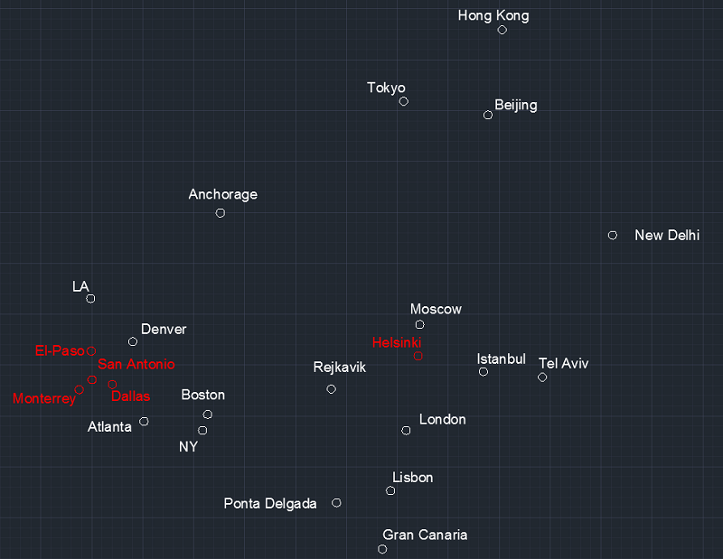
In this version, 6/7 cities are perfectly matched but El Paso made a 10% mistake as 100kms. It  divided to 50kms-50kms between El Paso and Monterrey.

Total mistake 10%/7cities= 1%. A bit worst than perfect.

Mexico City

Mexico City Monterrey 715 786
A320 1:05 743
A321 1:03 743
B738 1:02 747

Mexico City San Antonio 1.126 1.270
A320 1:39 774
A321 1:40 774
A319 1:48 774

Mexico City El Paso 1.559 1.557
B734 1:59 785

Mexico City LA 2.502 2.570
A319/320 2:57 837
B738 3:21 842
B748 2:44 885

Mexico City Denver 2.335 2.725
B737 3:19 828
A320 3:15 832

Mexico City Dallas 1.511 1.713
A320 2:01 795
B738 2:17 798

Mexico City NY 3.369 3.552
A320 3:51 852
B738 4:08 856
B752 4:18 866
B788 4:04 901

Mexico City Tokyo 11.266 10.412
B788 11:25 912

Mexico City London 8.914 8.423
B788 9:06 909
B789 9:26 909

Lets collect them in same frame:


Perfectly matches except one. Lets guess, which one of them that I corrected to? London, or Tokyo, perhaps they are far and we made a mistake?

Ahahah. No. Only New York wasn't matched and I changed the distance of NY from 3.500 to 3.800. With this change, we made a mistake in 9 cities 10%/9 = 1% again. A bit more worst than perfect. This time I'll do nothing for NY. Because map is almost perfect and I don't want to change it anymore, if I'm not very forced to.

Final situation after Mexico City placed:


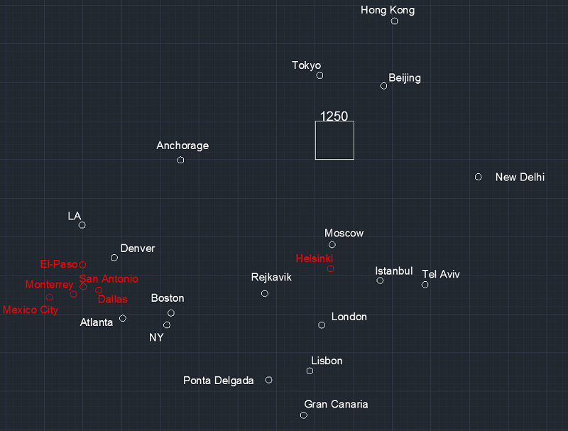
Map is scaled. I put on it a scale. You may measure all of the distances by counting the squares. Every small squares are 250kms and main squares contain 25 small squares are 1250kms lenght. Map was always scaled. You may control any of distances on the map when you want to do it in every versions. Everytime a small square is worth of 250kms.

Used data:

Monterrey   El Paso   993   
Monterrey   San Antonio   506   448
Monterrey   Dallas   1054   846
Monterrey   Denver   1800   
Monterrey   LA   2302   
Monterrey   Atlanta   1910   1746
Monterrey   New York   3183   2939
         
         
Mexico City Monterrey 786   
Mexico City San Antonio 1270   
Mexico City El Paso 1557   
Mexico City LA 2570   
Mexico City Denver 2725   2528
Mexico City Dallas 1713   
Mexico City NY   3552   3867
Mexico City Tokyo 10412 11266
Mexico City London 8423 8849
« Last Edit: January 18, 2018, 04:51:43 AM by brotherhood of the dome »
1+2+3+...+∞= 1

Come on bro, just admit that the the earth isn't a sphere, you won't even be wrong

*

wise

  • Professor
  • Flat Earth Scientist
  • 25446
  • The Only Yang Scholar in The Ying Universe
Re: Let's make a map all together depend on flight times
« Reply #173 on: January 18, 2018, 05:37:33 AM »
Puerto Vallarta

Third city inside Mexico city. The aim of this city is,  have another strong point in Mexico country. This will let us understand North America's continueus direction with a better estimation.

Puerto Vallarta - Helsinki 9.969 9.884
A359 10:56 904

Puerto Vallarta   Monterrey 774 966
A319/320 1:18 743

Puerto Vallarta   Mexico City 661 805
A320/321 1:08 710

Puerto Vallarta   Dallas 1.585 1.867
B738 2:20 800

Puerto Vallarta   Atlanta 2.509 2.737
A320 3:16 838

Puerto Vallarta   LA 1.963 2.202
B737 2:44 816
B738 2:38 825

Puerto Vallarta   NY 3.789 4.250
B739/738 4:43 901

Puerto Vallarta   Denver 2.135  2.295
B320 2:52 830
B737 2:41 824

Puerto Vallarta is added to the map as a point in Mexico country.


Puerto Vallarwa is added as a strong point in the intersection of the nearest cities and in the circles of the others, including Helsinki. Nothing is changed.

Used data:

Puerto Vallarta   Helsinki   9884   9969
Puerto Vallarta   Monterrey   966   774
Puerto Vallarta   Mexico City   805   700
Puerto Vallarta   Dallas   1867   1585
Puerto Vallarta   Atlanta   2737   2509
Puerto Vallarta   LA   2202   963
Puerto Vallarta   NY   4250   3789
Puerto Vallarta   Denver   2295   2135
Puerto Vallarta   El Paso   1225   

1+2+3+...+∞= 1

Come on bro, just admit that the the earth isn't a sphere, you won't even be wrong

*

wise

  • Professor
  • Flat Earth Scientist
  • 25446
  • The Only Yang Scholar in The Ying Universe
Re: Let's make a map all together depend on flight times
« Reply #174 on: January 18, 2018, 05:41:31 AM »
Panama City

Soon...
1+2+3+...+∞= 1

Come on bro, just admit that the the earth isn't a sphere, you won't even be wrong

*

wise

  • Professor
  • Flat Earth Scientist
  • 25446
  • The Only Yang Scholar in The Ying Universe
Re: Let's make a map all together depend on flight times
« Reply #175 on: January 18, 2018, 05:50:24 AM »
1+2+3+...+∞= 1

Come on bro, just admit that the the earth isn't a sphere, you won't even be wrong

*

rvlvr

  • 2148
Re: Let's make a map all together depend on flight times
« Reply #176 on: January 18, 2018, 05:52:43 AM »
When do you think you would be able to draw countries on that map? Even though I can follow the map to some extent, a full visualisation would help me a lot.

*

wise

  • Professor
  • Flat Earth Scientist
  • 25446
  • The Only Yang Scholar in The Ying Universe
Re: Let's make a map all together depend on flight times
« Reply #177 on: January 18, 2018, 05:58:11 AM »
When do you think you would be able to draw countries on that map? Even though I can follow the map to some extent, a full visualisation would help me a lot.

It is primarily John Davis'es job. For that, I should finish at least the inside and outside corners. I can do it by myself, but I have tried this before, I am not very successful in this regard.

Shortly, it is not ready to be drawn the countries, yet.
1+2+3+...+∞= 1

Come on bro, just admit that the the earth isn't a sphere, you won't even be wrong

*

rvlvr

  • 2148
Re: Let's make a map all together depend on flight times
« Reply #178 on: January 18, 2018, 06:16:11 AM »
Gotcha!

*

wise

  • Professor
  • Flat Earth Scientist
  • 25446
  • The Only Yang Scholar in The Ying Universe
Re: Let's make a map all together depend on flight times
« Reply #179 on: January 18, 2018, 10:20:47 PM »
Gotcha!

This is a common and open source working. Everyone may draw countries in any stage of working, also you can. Do not expect from me do everything, that I can't do everything in same time. But you may help, don't you?
1+2+3+...+∞= 1

Come on bro, just admit that the the earth isn't a sphere, you won't even be wrong