How would one, within scientific reason, and measurements, detect, beyond a shadow of a doubt, a flat earth?
A picture would be nice.
We have pictures, you dishonestly dismiss them.
Tens of MILLIONS of pictures with hundreds of thousands of people involved, all faked, all in on the conspiracy.
Tens of thousands of Hours of Video, hundreds of thousands of people involved, all faked, all in on the conspiracy.
Dozens of countries, hundreds of satellites sending back terabytes of data, all fakes, all the millions of people involved are liars, all in on the conspiracy.
That's your claim isn't it?
Do you have any idea how completely and utterly ridiculous that is?
Himawari 8 -- has sent back over a million pictures by itself. It's in geostationary orbit over the equator showing Japan because it's a Japanese weather satellite. It takes 11000 x 11000 pixel images of the Earth in 16 different spectra (visible light and near/mid/far-IR). You can count the pixels across and high and measure the oblateness of the Earth with it. You can watch LONG movies made from the data, it's all perfect But I guess thousands of Japanese people work 24/7 to FAKE a cloud accurate model of half the Earth every 10 minutes. /eyeroll
But Ok -- you want PROOF you can touch and feel... ZETETIC right? Something SIMPLE that is just OBVIOUS, right?
At your Sunrise, on any day, find the subsolar point of the sun. It will be ~6225.25 miles away. Find the point ~3112.625 miles away, or exactly half-way between you. So 6225.25 miles away the Sun is at 90°, 3112.625 miles from there it will be at 45° -- if the Earth was Flat that would mean the slope is 1, at double that distance (your location) it should be at slope = 0.5 (or ~26.5°) up but it's on your HORIZON. That does NOT work - you don't need to measure it or do any math you can just SEE that it's wrong:
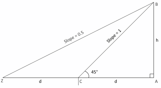
Simple right? It cannot POSSIBLY work on a Flat Earth.
How about something with less geometry?
To a fairly high degree of accuracy (for the sake of argument let's say only within +/- ONE THOUSAND kilometers), the distance from North Pole to Equator is known to be 10,002 km and the equatorial radius is 40,075 km. Does any Flat Earther have any other values they can substantiate as being the ACTUAL values, again +/- 1000 km -- HUGE margin of error right?
By trivial geometry we know that a circle with a radius of 10,002 km would have a circumference in the range of 62,844.4 km -- That is IMPOSSIBLY too Large for Earth. Even if
you think that π is 3 that STILL makes it 60,012 km around. You CANNOT make this fit.
Conversely, a circle with a circumference of 40,075 km would have a radius of just 6,378.13 km -- IMPOSSIBLY too Small for Earth.
Therefore the Earth simply cannot be flat if these measurements are anywhere even CLOSE to the actual values.
Can you show that the distance from the North Pole to the Equator is wrong by over 3000 km? Or is a simple circle too complex?
here are
some moreand
even moreWas it
faked in 1948 also?How about if you
look at balloon footage correctly?
How about if you
look at Chicago a little more carefully?
Does
" class="bbc_link" target="_blank" rel="noopener noreferrer">zooming in REALLY make the bottoms of things ACTUALLY over the horizon come back? No... No it does not... What happens is that people zoom in on things that are merely distant but NOT over the horizon and mistake that as evidence that zooming is the key. This video shows very clearly that NOTHING changes at the bottom as you zoom in -- the bottom of the city is still WELL over the horizon.
So how many ways do you need?