Aside from these weird arguments about what the OP meant.
 Geodesics.
 (
https://en.wikipedia.org/wiki/Geodesic) (
https://en.wikipedia.org/wiki/Geodesics_on_an_ellipsoid) (
https://en.wikipedia.org/wiki/Geodesics_on_an_ellipsoid#Applications) (
https://en.wikipedia.org/wiki/Geographical_distance)
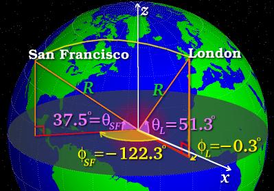
The two longitudinal geodesics begin parallel. The base is parallel with the lateral geodesic axis. The two longitudinal geodesics are 90 degrees to the lateral geodesic. They meet at the north pole with an angle of 60 degrees. If the geometry were flat, the two longitudinal lines with initial parallelism would retain that parallelism indefinitely, unless the geometry were not flat.
Another way of looking at it is that the form is a closed triangle consisting of an angular sum greater than 180 degrees. the geometry is convex.
Geodesics is a very well developed science engaged in defining the structure of geometry. this is one of the greatest, most irrefutable indications that the geometry of Earth is spherical. Geodesics when plotted via parallel transport (
https://en.wikipedia.org/wiki/Parallel_transport) across the geometry of earth are found to be behaving such that the geometry is curved, where initially parallel vectors become unparalleled when following a geodesic.
This does not happen on flat geometry.This is why mathematics
predicts proves a spherical earth.
This is also why flight navigation looks
weird.
"A planar approximation for the surface of the earth may be useful over small distances. The accuracy of distance calculations using this approximation become increasingly inaccurate as:
-The separation between the points becomes greater;
-A point becomes closer to a geographic pole.
The shortest distance between two points in plane is a straight line. The Pythagorean theorem is used to calculate the distance between points in a plane.
Even over short distances, the accuracy of geographic distance calculations which assume a flat Earth depend on the method by which the latitude and longitude coordinates have been projected onto the plane." ~ (
https://en.wikipedia.org/wiki/Geographical_distance#Flat-surface_formulae)
Flight navigation follows the geodesics of the spherical geometry of Earth,
and it works, fundamentally, to a complete degree of accuracy. When expressed in planar form the geodesic appears longer than the shortest line between two points:

This is simply an artifact of looking at a spherical geometry in planar form. In the image, the red line is the
shortest path between both points, flight times prove this. If the earth were flat, flight navigation would not ever have to consider this, nor would long flight radar tracking appear in the manner expressed here.

Global Circumnavigation.
This is a straight line.
If the Earth were a flat geometry flight paths would follow the shortest path in the
planner expression, not the
spherical geodesic which appears
longer in the planner expression. In the images above the
red lines are straight lines because
the geometry is spherical. If 2 planes that set off at the same time headed to the arrival point. the plane following the red line (in the first image) would get there
first. Explain this in the context of a flat earth geometry.
It is when, and only when those vectors are expressed across spherical geometry, that the red line is the shortest. This is
proven via practical application
every single time an airplane makes a long distance flight.
case closed?