>For the same reason you don't think the tops of those icebergs are flat. They aren't parallel to the surface of the sea.<
In the most cases, they are parallel (more or less). Haven't you seen those pictures? Should i put them here again?
[Image cropped vertically as a courtesy to readers]
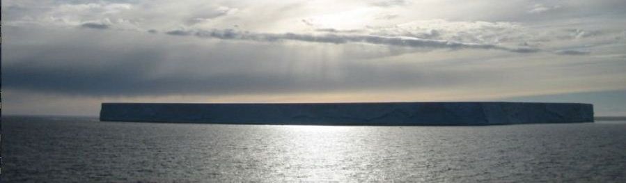
"Those icebergs" in the above from me refer to "other than tabular icebergs". This picture looks like a tabular iceberg according to cikljamas' own definitions.
cikljamas (just so be sure you know that I'm talking to you): if it's not a tabular iceberg, according to your definition, what kind is it, and why? Can you repeat those definitions of iceberg types again? You don't seem to have any problem repeating stuff
ad nauseum, even when you're wrong, so this should be little imposition.
Yo! cikljamas (just so be sure you know that I'm talking to you): what's the length from left to right in the photo above (in miles or km) of that iceberg? If you don't know, what are you trying to convince us of? If you do think you know, what is it, and, what evidence for this do you have to support this? The length of the iceberg matters. Does the perspective from below the top of the iceberg in the photo matter? If you don't understand why any of these is a question, since all has already been explained, you should not continue to argue. If you don't understand something, please just ask about that part rather than stubbornly insisting that ignorant bullshit is right. OK?
>The tabular icebergs spanning hundreds of km that you're carrying on about maintain more or less constant height above the level of the surrounding water. Constant height. Since the surface of the water is curved, then the surface of the ice is also curved. This curvature is too small to notice without careful measurement over short distances<
How is this in accordance with what you just have said (in a previous quote)? Are they parallel or not, at the end of the day? Alpha, what's going on with you? You are losing concentration, or what?
Yo, cikljamas (just so be sure you know that I'm talking to you): Why do you have a problem with the difference between a few km and hundreds of km? It's hard to tell the difference between a plane and the surface of a large sphere over a small area without careful measurement. No one disputes this, and it's a source of much of the ignorant "the Earth looks flat to me" nonsense, because most of the time, people can't see more than a few km, and the intellectually lazy aren't into subtlties. Similarly, it's difficult to tell the difference between parallel straight lines and concentric circles with a large, but close radii, over small distances. Because of this, even if something
looks flat it may be subtly curved, you just wouldn't know the difference on casual examination, which you seem to specialize in. You do have a problem recognizing the obvious, so sorry for not making this obvious enough even for you. It's just hard to fathom how obvious I should make things; I'm not used to dealing with people who know almost nothing.
>If you're measuring your survey elevations in reference to a sea level or similar datum, the curvature is already accounted for. Adding it in again would be "most unsatisfactory".<
On several occasions the six miles of water in the old Bedford Canal have been surveyed by the so-called "forward" process of levelling, which consisted in simply taking a sight of, say 20 chains, or 440 yards, noting the point observed, moving the instrument forward to that point, and taking a second observation; again moving the instrument forward, again observing 20 chains in advance, and so on throughout the whole distance. By this process, without making allowance for convexity, the surface of the water was found to be perfectly horizontal. But when the result was made known to several surveyors, it was contended "that when the theodolite is levelled, it is placed at right angles to the earth's radius--the line of sight from it being a tangent; and that when it is removed 20 chains forward, and again 'levelled,' it becomes a second and different tangent; and that indeed every new position is really a fresh tangent--as shown in the diagram, fig. 9, T 1, T 2, and T 3, representing the theodolite levelled at three different positions, and therefore square to the radii 1, 2, 3. Hence, levelling forward in this way, although making no allowance for rotundity, the rotundity or allowance for it is involved in the process."

Yo, cikljamas (just so be sure you know that I'm talking to you): How far would 20 chains be on the radius of the Earth be at the scale of this drawing? [Hint: the radius of the Earth is much greater than shown. It is 20 chains * 80 chains/mile * 4000 miles = 6,400,000 times as far as the distance between stations 1 and 2 (if they represent 20 chains) in figure 9. Almost flat. In other words, the difference in level between the two will be minuscule, not the obvious angle represented in the exaggerated drawing. This is the sort of deception Mr. Rowbotham engages in, so beware believing
anything he writes.
This is a very ingenious and plausible argument,
Ingenious because it's subtly wrong. Not so plausible once yo know enough to recognize the sleight of hand.
by which the visible contradiction between the theory of rotundity and the results of practical levelling is explained; and many excellent mathematicians and geodesists have been deceived by it.
Yo, cikljamas (just so be sure you know that I'm talking to you): Nope. Sorry. This is what surveyors and geodesists
do for a living. If they continually failed in their measurements, they would fail in their jobs. If they were using the wrong model (flat, for instance), they would
continually fail because their measurements wouldn't match reality.
Logically, however, it will be seen that it is not a proof of rotundity; it is only an explanation or reconciliation of results with the supposition of rotundity, but does not prove it to exist.
There is no proof the world is very nearly spherical, but large-scale surveys would
not work if we assume the Earth were flat, so we can throw that idea right out!
The following modification was therefore adopted by the author, in order that convexity, if it existed, might be demonstrated. A theodolite was placed at the point A, in fig. 10, and levelled; it was then directed over the flag-staff B to the cross-staff C--the instrument A, the flag-staff B, and the cross-staff C, having exactly the same altitude. The theodolite was then advanced to B, the flag-staff to C, and the cross-staff to D, which was thus secured .as a continuation of one and the same line of sight A, B, C, prolonged to D, the altitude of D being the same as that of A, B, and C. The theodolite was again moved forward to the position C, the flag-staff to D, and the cross-staff to the point E--the line of sight to which was thus again secured as a prolongation of A, B, C, D, to E. The process was repeated to F, and onwards by 20 chain lengths to the end of six miles of the canal, .and parallel with it.
By thus having an object between the theodolite and the cross-staff, which object in its turn becomes a test or guide by which the same line of sight is continued throughout the whole length surveyed, the argument or explanation which is dependent upon the supposition of rotundity, and that each position of the theodolite is a different tangent, is completely destroyed. The result of this peculiar or modified survey, which has been several times repeated, was that the line of sight and the surface of the water ran parallel to each other; and as the line of sight was, in this instance, a right line, the surface of the water for six miles was demonstrably horizontal.
How much difference, in inches or cm, would there be between flat and spherical (with a radius of 4000 miles) surfaces over a distance of 20 chains? Compare with the accuracy of a survey shot over this distance? If you don't know, then how can you evaluate the validity of this claim?

This mode of forward levelling is so very exact and satisfactory,
How exact? Specifically. Numbers, please, for 19th-Century instruments, with justification for your answer. Don't know? Well...
that the following further illustration may be given with advantage.[/b] In fig. 11, let A, B, C, represent the first position, respectively of the theodolite, flag-staff, and cross-staff; B, C, D, the second position; C, D, E, the third position; and D, E, F, the fourth; similarly repeated throughout the whole distance surveyed.

The remarks thus made in reference to simple "forward" levelling, apply with equal force to what is called by surveyors the "back-and-fore-sight" process, which consists in reading backwards a distance equal to the distance read forwards. This plan is adopted to obviate the necessity for calculating, or allowing for the earth's supposed convexity.
You can also use this method:

Question (for cikljamas, in case there's he's not sure) : have you done any land surveying? If so, what area (roughly) in hectares, acres, square miles, km
2, etc. was the survey? How many land surveys use "shots" three miles or more n length? What was the purpose, and accuracy, of any such surveys? What are the potential complications of using such long shots? How can those problems be mitigated? What is the typical length of the longer "shots" of a competently-executed land survey? Why?
[Edit to add] Why is this in the Antarctic Midnight Sun thread? Shouldn't your stuff about Bedford Level, etc. gone into "Complete Nonsense"?