Map

  • 145 Replies
  • 59666 Views
?

inquisitive

  • 5108
  • +0/-0
Re: Map
« Reply #30 on: March 23, 2015, 05:14:05 AM »
wolf, if you can tell me how you calculate an aircraft's speed, then your equation makes sense. the fact is, there's no way to do that unless you already know the distance you're travelling. as you're trying to find the distance, you can't calculate speed.

Your almost on the answer.
Many ways to calculate the air speed itself. But modern aircraft use a pitot tube, that measures air pressure. Increased air speed results in increased air pressure.
Calibrate this instrument with ground based measurements and now you have an accurate means to measure air speed. Speed over time gives you distance.
My father has been a pilot before he stuck a gps in this plane and that is exactly how he calculated his distance.
Obviously wind will change your ground speed. But this is not an unknown, and can to a certain degree be calculated before taking off with proper planning, by calling in ground based weather stations on your route. This is generally how pilots used to do it before gps, and they managed to still get to a 2 km long airstrip over 1000km away.

JRowe, as I am not sure on your perspective of the world map, is the map I linked above your accepted map? If not I can do some calculations on your version.

planes work by being pointed in the correct direction, and the pilots using their eyes. they don't predict the wind speed caused by, for example, aetheric whirlpools which don't exist in the round earth model.

i accept dual earth theory, in which the top and bottom of the earth is inhabited. an approximate map is given in the first reply to this thread.
How do they fly at night?

electric lights. have you ever been on a plane? it is easy to spot cities, and even see which parts are airfields. in addition, gps towers exist on land, so the system is more reliable there, they can correct far more easily.
There are no GPS towers.  Refer to the published documentation.  A GPS receiver shows the moving satellites.

*

MaNaeSWolf

  • 2623
  • +1/-3
  • Show me the evidence
Re: Map
« Reply #31 on: March 23, 2015, 05:15:05 AM »
planes work by being pointed in the correct direction, and the pilots using their eyes. they don't predict the wind speed caused by, for example, aetheric whirlpools which don't exist in the round earth model.

If that was the case, How would you explain night flying on 1000km + trips? How do fighter planes land on aircraft carriers in the middle of the sea in the dead of night?
How would you explain to my farther and all the 550 000 USA pilots that all that air stuff is irrelevant, all they need to do
planes work by being pointed in the correct direction

i accept dual earth theory, in which the top and bottom of the earth is inhabited. an approximate map is given in the first reply to this thread.

Ill do some models on your version when I have the time.
Anything I need to know before I do?
If you move fast enough, everything appears flat

*

JRoweSkeptic

  • Flat Earth Believer
  • 5407
  • +0/-0
  • DET Developer
Re: Map
« Reply #32 on: March 23, 2015, 05:17:32 AM »
wolf, if you can tell me how you calculate an aircraft's speed, then your equation makes sense. the fact is, there's no way to do that unless you already know the distance you're travelling. as you're trying to find the distance, you can't calculate speed.

Your almost on the answer.
Many ways to calculate the air speed itself. But modern aircraft use a pitot tube, that measures air pressure. Increased air speed results in increased air pressure.
Calibrate this instrument with ground based measurements and now you have an accurate means to measure air speed. Speed over time gives you distance.
My father has been a pilot before he stuck a gps in this plane and that is exactly how he calculated his distance.
Obviously wind will change your ground speed. But this is not an unknown, and can to a certain degree be calculated before taking off with proper planning, by calling in ground based weather stations on your route. This is generally how pilots used to do it before gps, and they managed to still get to a 2 km long airstrip over 1000km away.

JRowe, as I am not sure on your perspective of the world map, is the map I linked above your accepted map? If not I can do some calculations on your version.

planes work by being pointed in the correct direction, and the pilots using their eyes. they don't predict the wind speed caused by, for example, aetheric whirlpools which don't exist in the round earth model.

i accept dual earth theory, in which the top and bottom of the earth is inhabited. an approximate map is given in the first reply to this thread.
How do they fly at night?

electric lights. have you ever been on a plane? it is easy to spot cities, and even see which parts are airfields. in addition, gps towers exist on land, so the system is more reliable there, they can correct far more easily.
There are no GPS towers.  Refer to the published documentation.  A GPS receiver shows the moving satellites.

satellites don't exist. refer to basic principles of flat earth theory. you might as well say 'the earth is round, refer to liars.'
http://fet.wikia.com
dualearththeory.proboards.com/
On the sister site if you want to talk.

*

JRoweSkeptic

  • Flat Earth Believer
  • 5407
  • +0/-0
  • DET Developer
Re: Map
« Reply #33 on: March 23, 2015, 05:19:24 AM »
planes work by being pointed in the correct direction, and the pilots using their eyes. they don't predict the wind speed caused by, for example, aetheric whirlpools which don't exist in the round earth model.

If that was the case, How would you explain night flying on 1000km + trips? How do fighter planes land on aircraft carriers in the middle of the sea in the dead of night?
How would you explain to my farther and all the 550 000 USA pilots that all that air stuff is irrelevant, all they need to do
planes work by being pointed in the correct direction

i accept dual earth theory, in which the top and bottom of the earth is inhabited. an approximate map is given in the first reply to this thread.

Ill do some models on your version when I have the time.
Anything I need to know before I do?

radio waves etc are still able to aid location. with military planes, that's especially accurate. i explained this previously too.

i have a thread called 'my flat earth model' in the information repository where i refined my theory. near the end of page two is the most complete expression of it available.
http://fet.wikia.com
dualearththeory.proboards.com/
On the sister site if you want to talk.

?

inquisitive

  • 5108
  • +0/-0
Re: Map
« Reply #34 on: March 23, 2015, 05:20:17 AM »
wolf, if you can tell me how you calculate an aircraft's speed, then your equation makes sense. the fact is, there's no way to do that unless you already know the distance you're travelling. as you're trying to find the distance, you can't calculate speed.

Your almost on the answer.
Many ways to calculate the air speed itself. But modern aircraft use a pitot tube, that measures air pressure. Increased air speed results in increased air pressure.
Calibrate this instrument with ground based measurements and now you have an accurate means to measure air speed. Speed over time gives you distance.
My father has been a pilot before he stuck a gps in this plane and that is exactly how he calculated his distance.
Obviously wind will change your ground speed. But this is not an unknown, and can to a certain degree be calculated before taking off with proper planning, by calling in ground based weather stations on your route. This is generally how pilots used to do it before gps, and they managed to still get to a 2 km long airstrip over 1000km away.

JRowe, as I am not sure on your perspective of the world map, is the map I linked above your accepted map? If not I can do some calculations on your version.

planes work by being pointed in the correct direction, and the pilots using their eyes. they don't predict the wind speed caused by, for example, aetheric whirlpools which don't exist in the round earth model.

i accept dual earth theory, in which the top and bottom of the earth is inhabited. an approximate map is given in the first reply to this thread.
How do they fly at night?

electric lights. have you ever been on a plane? it is easy to spot cities, and even see which parts are airfields. in addition, gps towers exist on land, so the system is more reliable there, they can correct far more easily.
There are no GPS towers.  Refer to the published documentation.  A GPS receiver shows the moving satellites.

satellites don't exist. refer to basic principles of flat earth theory. you might as well say 'the earth is round, refer to liars.'
What does my tv dish point at.  Note on the south coast and dish points south.

*

JRoweSkeptic

  • Flat Earth Believer
  • 5407
  • +0/-0
  • DET Developer
Re: Map
« Reply #35 on: March 23, 2015, 05:22:08 AM »
wolf, if you can tell me how you calculate an aircraft's speed, then your equation makes sense. the fact is, there's no way to do that unless you already know the distance you're travelling. as you're trying to find the distance, you can't calculate speed.

Your almost on the answer.
Many ways to calculate the air speed itself. But modern aircraft use a pitot tube, that measures air pressure. Increased air speed results in increased air pressure.
Calibrate this instrument with ground based measurements and now you have an accurate means to measure air speed. Speed over time gives you distance.
My father has been a pilot before he stuck a gps in this plane and that is exactly how he calculated his distance.
Obviously wind will change your ground speed. But this is not an unknown, and can to a certain degree be calculated before taking off with proper planning, by calling in ground based weather stations on your route. This is generally how pilots used to do it before gps, and they managed to still get to a 2 km long airstrip over 1000km away.

JRowe, as I am not sure on your perspective of the world map, is the map I linked above your accepted map? If not I can do some calculations on your version.

planes work by being pointed in the correct direction, and the pilots using their eyes. they don't predict the wind speed caused by, for example, aetheric whirlpools which don't exist in the round earth model.

i accept dual earth theory, in which the top and bottom of the earth is inhabited. an approximate map is given in the first reply to this thread.
How do they fly at night?

electric lights. have you ever been on a plane? it is easy to spot cities, and even see which parts are airfields. in addition, gps towers exist on land, so the system is more reliable there, they can correct far more easily.
There are no GPS towers.  Refer to the published documentation.  A GPS receiver shows the moving satellites.

satellites don't exist. refer to basic principles of flat earth theory. you might as well say 'the earth is round, refer to liars.'
What does my tv dish point at.  Note on the south coast and dish points south.

this is q&a not debate, and that topic has already been covered numerous times. i'm not going off topic further, i suggest you try learning about flat earth theory before you argue against it.
http://fet.wikia.com
dualearththeory.proboards.com/
On the sister site if you want to talk.

*

Pongo

  • 6752
  • +1/-0
Re: Map
« Reply #36 on: March 23, 2015, 05:28:18 AM »
Lets all keep in mind that this isn't a debate forum.

*

MaNaeSWolf

  • 2623
  • +1/-3
  • Show me the evidence
Re: Map
« Reply #37 on: March 23, 2015, 05:30:33 AM »

radio waves etc are still able to aid location. with military planes, that's especially accurate. i explained this previously too.


For this to work the aircraft carrier/secret base will have to emit radio signals. This would be a specifically easy way for the enemy to identify their location. In fact, on a flat earth, modern warfare is entirely different.

But I certainly can confirm that my father does not use radio frequency to fly his new small plane to a remote airstrip a few times a year. I can give you the google earth location of the place. There are zero landmarks there to "see" where you are going.
https://www.google.co.za/maps/place/Ingwelala/@-24.1563907,31.3859126,1003m/data=!3m1!1e3!4m2!3m1!1s0x1ec33b3da6923cc3:0x9c3e7908f9ce51ef
It might look like those huts are above the trees from satellite view, trust me, there is zero chance of seeing them from 100m up unless you are almost 5 km away.

There is also no new fancy transmitting equipment in this place. GPS now. before that, good flight planning. BTW, he hardly needs to do much planning with is new GPS now.
I have done this flight many times, can personally verify my farther does not work for NASA!
If you move fast enough, everything appears flat

*

JRoweSkeptic

  • Flat Earth Believer
  • 5407
  • +0/-0
  • DET Developer
Re: Map
« Reply #38 on: March 23, 2015, 05:34:22 AM »

radio waves etc are still able to aid location. with military planes, that's especially accurate. i explained this previously too.


For this to work the aircraft carrier/secret base will have to emit radio signals. This would be a specifically easy way for the enemy to identify their location. In fact, on a flat earth, modern warfare is entirely different.

But I certainly can confirm that my father does not use radio frequency to fly his new small plane to a remote airstrip a few times a year. I can give you the google earth location of the place. There are zero landmarks there to "see" where you are going.
https://www.google.co.za/maps/place/Ingwelala/@-24.1563907,31.3859126,1003m/data=!3m1!1e3!4m2!3m1!1s0x1ec33b3da6923cc3:0x9c3e7908f9ce51ef
It might look like those huts are above the trees from satellite view, trust me, there is zero chance of seeing them from 100m up unless you are almost 5 km away.

There is also no new fancy transmitting equipment in this place. GPS now. before that, good flight planning. BTW, he hardly needs to do much planning with is new GPS now.
I have done this flight many times, can personally verify my farther does not work for NASA!

once again, gps works over land as that is where towers are located. knowing the location also helps.
this is not debate, and that topic has been beaten back several times already. use the search function.
http://fet.wikia.com
dualearththeory.proboards.com/
On the sister site if you want to talk.

?

Weatherwax

  • 761
  • +0/-0
  • Grand Lover of Satan and Science
Re: Map
« Reply #39 on: March 23, 2015, 05:36:59 AM »
Lets all keep in mind that this isn't a debate forum.

The question was: Has there need any progress on the flat earth map?

Thanks for your map JRowe, it would be great if wolf could explore it a bit more. But that's not the general flat earth (one-sided) belief. It would be great to see a generally accepted flat earth map, and as I said, this seems fairly crucial to the proposal.
A delusion is something that someone believes in despite a total lack of evidence - Prof. Richard Dawkins.

?

inquisitive

  • 5108
  • +0/-0
Re: Map
« Reply #40 on: March 23, 2015, 05:41:18 AM »

radio waves etc are still able to aid location. with military planes, that's especially accurate. i explained this previously too.


For this to work the aircraft carrier/secret base will have to emit radio signals. This would be a specifically easy way for the enemy to identify their location. In fact, on a flat earth, modern warfare is entirely different.

But I certainly can confirm that my father does not use radio frequency to fly his new small plane to a remote airstrip a few times a year. I can give you the google earth location of the place. There are zero landmarks there to "see" where you are going.
https://www.google.co.za/maps/place/Ingwelala/@-24.1563907,31.3859126,1003m/data=!3m1!1e3!4m2!3m1!1s0x1ec33b3da6923cc3:0x9c3e7908f9ce51ef
It might look like those huts are above the trees from satellite view, trust me, there is zero chance of seeing them from 100m up unless you are almost 5 km away.

There is also no new fancy transmitting equipment in this place. GPS now. before that, good flight planning. BTW, he hardly needs to do much planning with is new GPS now.
I have done this flight many times, can personally verify my farther does not work for NASA!

once again, gps works over land as that is where towers are located. knowing the location also helps.
this is not debate, and that topic has been beaten back several times already. use the search function.
Question.  Where are the towers and how do you explain receivers showing the moving locations of the transmitters?  GPS is the main tool now used for surveying, mapping and navigation across the earth.  Works accurately in the middle of oceans.

*

MaNaeSWolf

  • 2623
  • +1/-3
  • Show me the evidence
Re: Map
« Reply #41 on: March 23, 2015, 05:42:09 AM »
do you have any idea how many resources it takes to come up with a detailed, working map? at present, the flat earth society is more concerned with raising awareness. it doesn't have the budget or resources, and neither do individual members. you try producing a working map alone.

approximately for a dual earth map:


To get some idea of scale, I need a calibration distance. Can you please give me 2 points that you believe can be used for calibration. The further away the better
If you move fast enough, everything appears flat

*

iWitness

  • 1173
  • +0/-0
  • If the earth is round then what is your problem?
Re: Map
« Reply #42 on: March 23, 2015, 10:13:52 AM »
Thank you iwitness. That's the best effort so far.

Seriously looking for a accepted map.
From what I understand from iWitness, there is no current working map of the world?

How do we travel?

I said there is no publicly available perfect map of the world. What they have done is taken the most commonly traveled routes and mapped those, but anything that does not add up mathematically they discount as 'magnetic declination".

There are some very important areas that are not accounted for like east of China where it becomes pitch black 24 hours a day, north of the Caspian sea where it leads to the northern ocean (also lays in darkness), and of course Antarctica and the Arctic (which are both part of the Ice Wall).

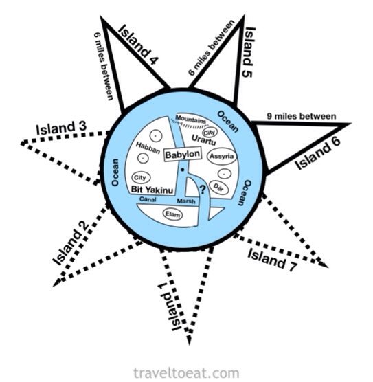
The Babylonian Map (oldest map of the world) shows 7 islands around the main world land mass, some of which lay in darkness:


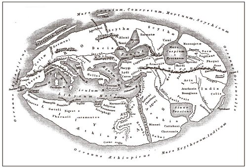
Here is an ancient map that shows the chasm that separates us from the Garden of Eden in the east of China, which lays in darkness, and also the wind portals at the 4 corners of the earth.


Notice the Mediterranean Sea in the Middle-left of the map and the Caspian Sea in the north.

The most advanced civilizations of the past like the Romans, Babylonians, Greeks and Hebrews believed the earth was flat and had incredibly the accurate flat earth maps. The Bible even forewarns that the world will be deceived by the evil one and trade the Truth for a Lie. So why is it so hard to believe?

Disclaimer: I am confused. Everything I say is speculative and not admissible in a court of law; however, I am neither insane nor a threat to myself or others. I am simply curious about everything in life and enjoy talking about crazy shit. Oh, & btw I like turtles.

*

FalseProphet

  • 3696
  • +0/-0
  • Life is just a tale
Re: Map
« Reply #43 on: March 23, 2015, 10:42:11 AM »
Quote
There are some very important areas that are not accounted for like east of China where it becomes pitch black 24 hours a day,

I barely survived reading this sentence. Anybody else?

*

MaNaeSWolf

  • 2623
  • +1/-3
  • Show me the evidence
Re: Map
« Reply #44 on: March 23, 2015, 11:24:16 AM »
I barely survived reading this sentence. Anybody else?

I dont quite know where to start? Do any other FE people have a similar approach to iWitness?
If you move fast enough, everything appears flat

?

Weatherwax

  • 761
  • +0/-0
  • Grand Lover of Satan and Science
Re: Map
« Reply #45 on: March 23, 2015, 11:31:28 AM »
We need a "Does Japan Exist?" thread.
A delusion is something that someone believes in despite a total lack of evidence - Prof. Richard Dawkins.

*

MaNaeSWolf

  • 2623
  • +1/-3
  • Show me the evidence
Re: Map
« Reply #46 on: March 23, 2015, 11:32:22 AM »
We need a "Does Japan Exist?" thread.

Seriously?
Did that happen?
If you move fast enough, everything appears flat

*

JRoweSkeptic

  • Flat Earth Believer
  • 5407
  • +0/-0
  • DET Developer
Re: Map
« Reply #47 on: March 23, 2015, 11:45:23 AM »

radio waves etc are still able to aid location. with military planes, that's especially accurate. i explained this previously too.


For this to work the aircraft carrier/secret base will have to emit radio signals. This would be a specifically easy way for the enemy to identify their location. In fact, on a flat earth, modern warfare is entirely different.

But I certainly can confirm that my father does not use radio frequency to fly his new small plane to a remote airstrip a few times a year. I can give you the google earth location of the place. There are zero landmarks there to "see" where you are going.
https://www.google.co.za/maps/place/Ingwelala/@-24.1563907,31.3859126,1003m/data=!3m1!1e3!4m2!3m1!1s0x1ec33b3da6923cc3:0x9c3e7908f9ce51ef
It might look like those huts are above the trees from satellite view, trust me, there is zero chance of seeing them from 100m up unless you are almost 5 km away.

There is also no new fancy transmitting equipment in this place. GPS now. before that, good flight planning. BTW, he hardly needs to do much planning with is new GPS now.
I have done this flight many times, can personally verify my farther does not work for NASA!

once again, gps works over land as that is where towers are located. knowing the location also helps.
this is not debate, and that topic has been beaten back several times already. use the search function.
Question.  Where are the towers and how do you explain receivers showing the moving locations of the transmitters?  GPS is the main tool now used for surveying, mapping and navigation across the earth.  Works accurately in the middle of oceans.


Quote
this is not debate, and that topic has been beaten back several times already. use the search function.
http://fet.wikia.com
dualearththeory.proboards.com/
On the sister site if you want to talk.

*

JRoweSkeptic

  • Flat Earth Believer
  • 5407
  • +0/-0
  • DET Developer
Re: Map
« Reply #48 on: March 23, 2015, 11:46:57 AM »
do you have any idea how many resources it takes to come up with a detailed, working map? at present, the flat earth society is more concerned with raising awareness. it doesn't have the budget or resources, and neither do individual members. you try producing a working map alone.

approximately for a dual earth map:


To get some idea of scale, I need a calibration distance. Can you please give me 2 points that you believe can be used for calibration. The further away the better

i accept distances measured over land, as they may be verified by anyone. take any two cities (excluding russia) and the distance between them, so long as it is a straight line over land, the mainstream measurement should be correct.
http://fet.wikia.com
dualearththeory.proboards.com/
On the sister site if you want to talk.

?

inquisitive

  • 5108
  • +0/-0
Re: Map
« Reply #49 on: March 23, 2015, 11:50:50 AM »
Please give distances between Perth - Brisbane, Darwin - Perth and Darwin - Brisbane.

*

JRoweSkeptic

  • Flat Earth Believer
  • 5407
  • +0/-0
  • DET Developer
Re: Map
« Reply #50 on: March 23, 2015, 11:56:38 AM »
Please give distances between Perth - Brisbane, Darwin - Perth and Darwin - Brisbane.

why?
i have said all i need to.
regardless, those cities are bad examples, as from what i can see the routes taken from one to the other is not remotely straight. if you can find a straight line distance, traveled over land, i will accept it.

asking questions for the sake of asking questions is a bad habit.

darwin to brisbane is the most reliable, at around 3400km, so that measurement is more acceptable, but it isn't great.
http://fet.wikia.com
dualearththeory.proboards.com/
On the sister site if you want to talk.

*

ausGeoff

  • 6091
  • +0/-0
Re: Map
« Reply #51 on: March 23, 2015, 11:58:19 AM »
approximately for a dual earth map:


Do you accept that both of these maps are planar projections of the spherical earth model?

You've been asked several times now to post a diagram of your proposed flat earth map.  Why can you not do so?  Is it that you don't have one?

You must acknowledge that it's very difficult, if not impossible, to discuss the pros and cons of your flat earth map if we don't actually have the map to refer to.

*

MaNaeSWolf

  • 2623
  • +1/-3
  • Show me the evidence
Re: Map
« Reply #52 on: March 23, 2015, 12:05:07 PM »
Okay. Using Australia as my calibration.
But not doing it tonight. its late here already.
Will probably do a sun model as well while I am at it.

I know it wont change anyone's minds what ever my results, but its fun to play.

If you move fast enough, everything appears flat

*

Son of Orospu

  • Jura's b*tch and proud of it!
  • 37800
  • +1/-0
  • I have artificial intelligence
Re: Map
« Reply #53 on: March 23, 2015, 12:31:45 PM »
Please give distances between Perth - Brisbane, Darwin - Perth and Darwin - Brisbane.

Is your Google broken?  Seriously, just stop please. 

?

inquisitive

  • 5108
  • +0/-0
Re: Map
« Reply #54 on: March 23, 2015, 01:24:09 PM »
Please give distances between Perth - Brisbane, Darwin - Perth and Darwin - Brisbane.

Is your Google broken?  Seriously, just stop please.
So you accept those distances will be correct.  Will you please draw on map above.

*

ausGeoff

  • 6091
  • +0/-0
Re: Map
« Reply #55 on: March 23, 2015, 01:48:41 PM »
Please give distances between Perth - Brisbane, Darwin - Perth and Darwin - Brisbane.

Is your Google broken?  Seriously, just stop please.

Uh... you do understand that the distances quoted in Google, and the distances delineated on Google Maps are all calculated using geodetic surveying of a spherical model of the earth don't you jroa?  So how can a flat earther possibly use those distances and relate them to a (as yet non-existent) working flat earth map?

Or are you now agreeing that the round earth distances are correct?  Has to be one or the other... incorrect round earth distance, or hypothetical flat earth distances.

*

FlatOrange

  • 2458
  • +0/-0
Re: Map
« Reply #56 on: March 23, 2015, 02:58:57 PM »
I don't see why this is so difficult. All you need to do is take a few measurements from different locations, if these fit with the published distances you will know that land masses on maps are correct. Then you just have to plonk them on a flat map.

i don't have a problem with measured distances on land, it's distances across sea and through air i have a problem with. how would you suggest we measure those? first, say how they could reliably be measured in the first place, and second say how you expect someone without a plane or ship to do the same, without supposing existing round earth maps are accurate.

you could not come up with a map yourself without relying on technology that is not acceptable. why do you expect us to?
Transoceanic cables. Could you measure the speed at which a message is transmitted? Agree on a time (using technology) send a telegram or whatever and measure the delay?
Quote from: Heiwa
You are ignoring this user. Show me the post.

*

JRoweSkeptic

  • Flat Earth Believer
  • 5407
  • +0/-0
  • DET Developer
Re: Map
« Reply #57 on: March 23, 2015, 03:46:40 PM »
I don't see why this is so difficult. All you need to do is take a few measurements from different locations, if these fit with the published distances you will know that land masses on maps are correct. Then you just have to plonk them on a flat map.

i don't have a problem with measured distances on land, it's distances across sea and through air i have a problem with. how would you suggest we measure those? first, say how they could reliably be measured in the first place, and second say how you expect someone without a plane or ship to do the same, without supposing existing round earth maps are accurate.

you could not come up with a map yourself without relying on technology that is not acceptable. why do you expect us to?
Transoceanic cables. Could you measure the speed at which a message is transmitted? Agree on a time (using technology) send a telegram or whatever and measure the delay?

i doubt that would work. electronically transmitted messages are near-instant, that would measure reaction time more than transmission time, and would fail to take into account unexpected hitches or patches of resistance.
http://fet.wikia.com
dualearththeory.proboards.com/
On the sister site if you want to talk.

*

MaNaeSWolf

  • 2623
  • +1/-3
  • Show me the evidence
Re: Map
« Reply #58 on: March 23, 2015, 07:30:51 PM »
Transoceanic cables. Could you measure the speed at which a message is transmitted? Agree on a time (using technology) send a telegram or whatever and measure the delay?

Why did I not think of this?
There is a delay in transmission time over long distances due to the fact that it takes time for light to pass through the fiber in the ocean - ping. Will do some reading to see how it can be used to calculate distances.
Ping is a huge problem for gamers in South Africa where the servers are in the UK or USA. We never see pings below 170. I will see what that translates to to assist with a map
If you move fast enough, everything appears flat

*

Son of Orospu

  • Jura's b*tch and proud of it!
  • 37800
  • +1/-0
  • I have artificial intelligence
Re: Map
« Reply #59 on: March 23, 2015, 08:11:22 PM »
Transoceanic cables. Could you measure the speed at which a message is transmitted? Agree on a time (using technology) send a telegram or whatever and measure the delay?

Why did I not think of this?
There is a delay in transmission time over long distances due to the fact that it takes time for light to pass through the fiber in the ocean - ping. Will do some reading to see how it can be used to calculate distances.
Ping is a huge problem for gamers in South Africa where the servers are in the UK or USA. We never see pings below 170. I will see what that translates to to assist with a map

It is not just the distance or medium.  All of the devices that the signal passes through each add an amount of delay.  You do not have just a long cable going from your house to a US server.  There are many devices in between.  With more distance, you have more devices handling the signal.