The claims made in the first message posted here, on this thread, are as follows:
A distance of 15 - 25 km
Altitude of the photographer, 2 - 12 meters
A ship on the horizon, and an opposing shoreline
As I have explained already, the reason the lower portion of the ship disappears in the photographs, even from 12 meters, is that the quality of the camera could not capture the entire details.
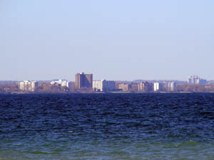
HERE IS A PHOTOGRAPH, TAKEN RIGHT ON THE BEACH OF CAP GRIS NEZ, A SHIP SEEN AT ABOUT HALF WAY TO DOVER, SOME 15 - 20 KM, EXACTLY AS IN THE PHOTOGRAPHS IN THE FIRST MESSAGE: NO ASCENDING SLOPE, THE SHIP BEING SEEN TOP TO BOTTOM, AND THE WHITE CLIFFS BEING SEEN IN FULL VIEW.
FROM THOSE 3 METERS ON THE BEACH, WE COULD NOT SEE ANYTHING BELOW 60,6 METERS ON A ROUND EARTH.
The original webpage, the photograph SHIPSPOTTING, the photographers right there on the Cap Gris Nez beach:

The next photograph, the ship being spotted:

Both photographs in full view:

THE PHOTOGRAPHERS ON THE BEACH OF CAP GRIS NEZ, SOME 2 METERS ABOVE THE WATER, I WILL GIVE YOU 3 METERS, NOTHING COULD BE SEEN UNDER 60,6 METERS ON A ROUND EARTH, BUT:

THE FULL DETAILS CAN BE SEEN, FULL HULL OF THE SHIP, FULL VIEW OF THE WHITE CLIFFS OF DOVER, NO ASCENDING OR DESCENDING SLOPES. The White Cliffs of Dover, here:
http://www.flickr.com/photos/cybernomad/4047745111/sizes/l/in/photostream/ full view just as in the above photograph...
A PHOTOGRAPH, TAKEN RIGHT ON THE BEACH, DISPROVES AND REFUTES THE CLAIMS MADE IN THE INITIAL MESSAGE POSTED HERE, SAME DISTANCE, 15 - 20 KM...
The discussion on this thread is over; I did not even have to resort to the photographs taken on the beach of Hamilton (65 km to Toronto, Lakeshore Blvd.):
http://www.flickr.com/photos/planetrick/487755017/http://www.flickr.com/photos/planetrick/487726854/in/photostream
(both photographs taken right on the beach, as can be seen in the captions, and in the rest of the photos)
or to bring in the heavy artillery, the fact the explosion from Tunguska was seen all the way from London:
http://theflatearthsociety.net/talk/viewtopic.php?f=7&t=1142PS The photograph from St. Catharines is taken from some 10-12 meters altitude, that is what I have been saying all along; STILL, you could not see the rooftop of the Sky Dome, there would be some 27 meters missing on a round earth from the visual obstacle...
A curvature of 59 meters means that we could barely see the first sign of land, the beach, from Toronto, and an ascending slope, in this photograph, the surface of Lake Ontario is completely flat, we CAN see the details WITHOUT any sign of curvature of 59 meters, please wake up...
http://farm1.static.flickr.com/117/312939439_ef682e2d8a_z.jpg?zz=1