So how do we deal with a theory that can't accomplish what cartographers have centuries ago?
Why should we assume that those cartographers were accurate or competent?
For over three hundred years between the 15th and 18th centuries California was depicted in popular maps as being an island off the west coast of North America, despite being colonized by supposedly intelligent men.
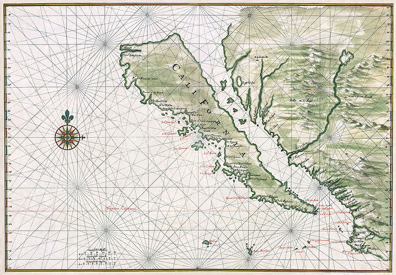
Between the 15th and 18th centuries the east and west coasts of North America were studied meticulously. California was colonized by many thousands of Europeans during this age of exploration. Generations lived and died believing that they were living on an island off the coast of America. If the Europeans couldn't figure out that they weren't colonizing an island, what makes you think that they could competently map the world?
Even in today's "modern era", it has been found that maps made in the 1990's show features which don't even exist. Features near very populated areas no less. Islands that don't exist. Shapes of coastlines being entirely different to that portrayed in maps. Distances that don't add up. If you are interested in the subject I'd suggest the book
How to Lie with Maps by Mark Monmonier.
Unless we have direct logs from the actual vessels in question, any map or distance on a map drawn by some cartographer sitting in a closet does not approach evidence in the slightest.
Shipping vessels aren't interested in studying the earth. They're interested in doing their job. It's wrong to assume that if a captain encountered a distance out of the ordinary that he wouldn't assume it due to currents or winds, or that he would make a big deal out of it to the press, or that the press would even care. He is a private individual, unlikely to even care himself, shrugging any discrepancy he may encounter on currents, wind, the quality of his ship engine, or whatever. I don't go around comparing my highway odometer readings to printed maps and contacting the press about it, do you?
That's why actual evidence is needed for any hypothesized distance an RE or otherwise predicts. Not assumption. Logs need to be compiled. Readings need to be compared. First hand accounts of all manner from routes all across the world need to be collected. This was never done to cement the Round Earth model. When building the Round earth model all the data we have comes from a few famous explorers in the past who made a single famous long trip between distant points and filled in the gaps along the way under the assumption of "well if this route took this long, then this other route no one has undertaken must take this long." They get their thoughts visualized and published and the public eats it up as instant fact. No one has collected logs and readings from vessels all round the world to build a single indisputable map of the world. Cartography is built on one assumption after the next from scant data here and there. There has never been an undertaking to create an accurate map of the world.