You may notice that bendy light theory would work fine if there were just the one northern gear, but you add even one southern gear, and you run into problems where those 2 gears converge. To an observer at a point near the equator rim stars would appear to be changing distance from each other over the course of the night.
At the equator the stars do seem to converge and then spread apart:

What if you happen to be in one of these immediate areas?
There are two Flat Earth Maps. One is the United Nations map where observers on the bottom tips of Australia and South America would be looking at different gear systems when they look Southward. And then there's the Columbus/Magellan map where observers on those continents would be looking at the same stellar system when they looked Southwards.
Which map is true remains to be seen. There would need to be a coordinated effort to study the southern stars from all parts of the Southern Hemidisk.
Nice double take Tom...
First off, that's a
wide angle shot you keep posting... I'm pretty sure I pointed that out to you before.
This is a much better representation of star paths in a full sky. Even given the wide angle nature of the image you referenced, there's nothing near the variance that would be expected with gears theory/bendy light theory.
Second off, it's not just the "United Nations" map, it's
Volivia's map, and
Rowbotham's map, and the map put out by
this site's promoters. All the same map.

Do you really want me to go all out in showing that there won't be a "coordinated effort" needed to debunk your new map?
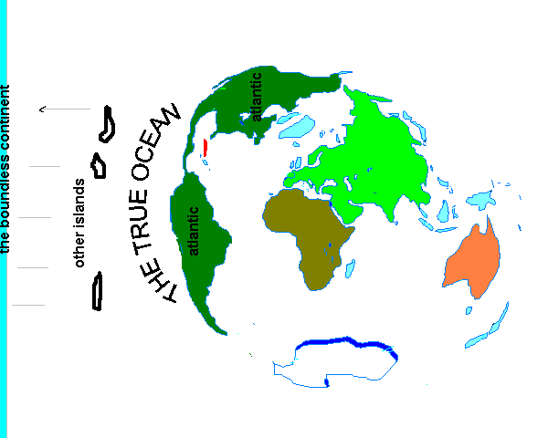
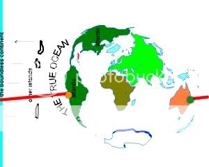
First point, appearance. This map looks like warped clipart garbage with MS paint frosting. What islands are the "other islands" drawn in on the left? What's the "boundless continent" referenced in the left border? What are those 2 light blue things clipping Antarctica? Why are the North and South American continents labeled "atlantic"? If the ice wall exists on this map, then where is that in reference to all of this?
Second point, citation. You cite this as Columbus's and Magellan's map, but give only a nutter's website as reference. I've never seen a 15'th century map with that perfect a representation of Africa. Show me a pic, a scan, or even a verifiable reference on a refutable site to a map similar to what you cite as a historical document. If you can't show a map, point us to the passages cited on the nutter website that you deemed sufficient, even with their lack of a real map, to cite as "proof" of a Columbus/Magellan conspiracy to all of us here. Please do so today, so you don't taint my Columbus day celebrations.
Third point, compass readings.
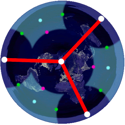
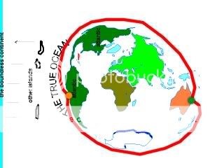
If you start at the north pole, and follow your compass in a straight line, you'll get to the south pole, or at least the ice wall. This works with RE and classical FE maps. Not so much with your new one. Yours curves and in one instance dead ends...
Fourth point, pacific oceanic voyages.
To go from the eastern coast of South America to the western coast of Australia you need only go in a line. RE says a straight line. Classic FE says a curved line. Tom's new map says line paths of that nature cannot exist.
To get from one point to the other on the new map, you have to take a longer coastal path.
That longer coastal path would be noted and/or observed by most/all sailors making that journey. Those voyages would be even longer that those classical FET maps would predict.
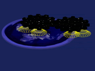
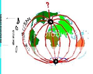
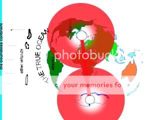
Fifth point, Star gears theory. I'm not sure whether you think this new map has 4 gears(1 north, 3 south), like this.

Or just 2 gears, like you seem to indicate.
Either way, gears theory for both setups have so many holes I'm not going to bother posting any arguments yet. They should be apparent to even a casual poster. If you want to continue to argue this map, cite which gears theory you espouse. I'll debate that.
My final point is that I've saved my post in it's entirety as an html document, and will do so from now on. If the mods decide to make this thread go away like they've made so many like it go away in the past I'll still have my arguments here pocketed for future use. I don't like wasting my time.