Show Posts

This section allows you to view all posts made by this member. Note that you can only see posts made in areas you currently have access to.


Topics - EvilToothpaste

Pages: 1 [2]
31
Flat Earth Q&A / Eratos' Experimental Revue
« on: February 23, 2007, 08:25:08 PM »
I think it would be cool to get a large-scale experiment together from people all over the world.  Having failed at coming up with my own idea, I would like to see who is interested in repeating Eratosthenes' estimate the Earths radius. 

Let's firstly use this thread to come up with a way to minimize measurement error and use Universal Time to standardize results.  Secondly, we can post experimental data.  Thirdly, analyze results. 

Then we can be content in the knowledge that our measurements were influenced by the UA and are moot....

32
Flat Earth Q&A / FE atmosphere
« on: January 23, 2007, 04:04:05 PM »
This post is redirected from the following thread:
http://theflatearthsociety.org/forums/viewtopic.php?p=101815&sid=3ac150aaad6facc090b42370e51a9cf3#101815

For example, say there is a finite height of said bucket.   Outside of the bucket is a vacuum, and the bucket has a constant upwards acceleration.  The bucket is filled with orange:


A pressure gradient has no distinct zero point as one increases altitude; it is a mathematical asymptote.  Thus, no matter how tall the finite bucket there always is a small amount of pressure exposed over the top edges of the bucket, as is indicated in red, below.  


After an appreciably large amount of time, there will be very little pressure at the bottom of the bucket.  

The Ice Walls would effectively have to be infinitely high to keep the atmosphere from escaping.  Granted, the rate of escaping molecules would decay exponentially, but that would be a direct result of the atmospheric pressure decaying proportionally as well.  

But perhaps we just haven't noticed a change in pressure yet.

33
Flat Earth Q&A / The Flat Sky
« on: January 15, 2007, 09:41:27 PM »
I thought this would be pretty interesting, but I don't know if anyone else has done this before because the search doesn't work too great.

What follows is what the FE model sun would look like standing on the Equator over a 36 hour period.  

Assumptions:
Sun is 3000 miles above Earth equator.
Radius of equator is 25000 / 4 = 6250 miles.
Sun is at its average radius.
Observer is looking north.

Use parametric equation of a circle so position of sun is based on time of day:
x=r*cos(t * pi/12)
y=r*sin(t * pi/12)

Use Distance formula to find distance from observer to sun at any time.

Use right triangle to find inclination of sun at any time:


now plot theta with respect to time of day:


The peaks at 90 degrees indicate when the sun is directly overhead (12 hours), and the minimum is midnight.  As you can see from the graph, the sun is still 14 degrees above the horizon at midnight.

The apparent speed of the sun through the sky can be found from the sum of the derivatives of the spherical coordinates theta (from above) and phi:


I tried to get mathematica to make a pretty spherical plot of all this but it was complaining too much.  

There needs to be a new FE model.  Someone should come up with some constants for the MOND that would create enough lensing for the sun to set (or would that crush us?).  Or figure out how the pressure gradient of the atmosphere effects the index of refraction.  

And again, if I screwed anything up just tell me and I'll recalculate.

34
Flat Earth Q&A / Here's Your Proof and Evidence
« on: January 11, 2007, 12:43:42 PM »
Because I'm tired of repeating myself I'm going to put these proofs all in one place.  Your review of my methods are encouraged.  

Quote from: "Declination over the Horizon"


I know I said earlier that I never wanted to see another photograph on here again.  However, I'm cramming tons of mathematical proof down your throats to back it up.  Chew well:


So here you have a diagram of an observer looking tangentially to the surface.  (observer is at bottom left, looking right along 'x')  

a: height of observer (assume 10 feet)
x: line-of-sight of observer
s: line-of-sight distance from observer to surface horizon
r: radius of spherical earth (4000 miles; a little large, but nice and pretty)
h: height an object must be in order to be seen by observer

Pythagoras tells us, for the left triangle:
(1)
r^2 +s^2 = (r + a)^2                

and for the right:
(2)
r^2 + (x - s)^2 = (r + h)^2      

For first (1) equation, solve for 's' and plug into second (2) equation.   Then solve second equation for 'h'.  (I used Mathmatica: i have the file if you want it)

Thus we can get a list of h (in feet, for your convinience) for every mile up to 20:

5.52
2.36
0.526
0.00763
0.810
2.93
6.37
11.1
17.2
24.6
33.3
43.4
54.7
67.4
81.4
96.8
113
131.
151.
171.

So at 20 miles, any object on your line of sight with the horizon (assuming a perfectly spherical surface) is 171 feet from the calm ocean surface.


Quote from: ""
Thinking the edges of the horizon should curve downwards on a spherical Earth is absolutely wrong.

You're not understanding the sphericity of the Round Earth.  The edges of a picture would only drop off on a 'cylindrical' Earth.  I know that's confusing, but just stay with me.  My proof above is correct:  objects do drop off like that.  However, just because it drops off does not mean that a horizon is going to curve down toward the edges of a picture.  You are taking what is valid in only one direction (away from you) and applying it to another direction (along the horizon).  

Ask yourself, where are these "edges" of the horizon you are talking about in your picture?  There are no "edges" in reality, right?  Does it matter which direction you point your camera?  No, it does not.  The horizon is the same all the way around.

Picture your self on the ocean looking at the horizon.  Now look all the way around yourself.  three-hundred and sixty degrees.  

Have you looked around?  Okan, now you just looked in a circle.  Keep following me here:

Let me stress this point that was proved in another thread:  you can see some amount of distance directly in front of you.  When you turn your head along the horizon, your eye-line is traversing a path that is a specific distance away from you.  

This path that is traversed is flat, right?  The horizon is flat.  Now picture the spherical Earth and the place you were standing.  The path traversed by your eyes is actually a circle on the surface of the sphere, is it not?  


Just like the circle on the surface of the sphere in this picture.  You are at the top.  

This path traversed by your eye-line all around is the horizon, and the horizon is a circle on the sphere of the earth.  This is because at every point around you, the distance I calculated in the other thread is the same at every direction you look.  You are at the center of a circle of the horizon.  

now it is flat because you are unbelievably smaller than this circle.  Like I said before:  you are 6 feet tall, the Earth is 42,000,000 feet in diameter.  Your height is negligible.  You can't 'see' anything, really.

Quote from: "this one has been updated"
Let me put a little more detail into my argument:

Quote
you cannot adequately explain why the curvature of the earth is not apparent on an ocean horizon which stretches one hundred miles in length.


Ah, but I can:

Perhaps you have just never listened long enough to adequately understand why?  What follows is a great opportunity for you.  

Tell me, exactly how far does this ocean horizon stretch, in length, outside of your picture.  How far?  Tell me if I'm wrong:  360 degrees.  All the way around.  That does not necessarily mean the Earth is flat.  It does not mean the Earth is spherical.  It does not mean it is square.  It could be infinite.  It could be a trapezoid.  But it could not be very small.  Right?  

What it does mean is that you can see all the way around yourself.  Congratulations: that which you observe does not mean a damn thing, and you cannot come to a single conclusion about where you are or what you are standing on.  You're in the same sinking boat as all of us.  But do not be discouraged; we have an ability to organize many different observations all at once to better understand what it is we are doing, where we really are, and how to get somewhere we have never been.  We will use this ability henceforth to assemble a picture of what it is we are standing on.  

Lets assume first we are standing on a perfectly flat disk that is 16000 miles in diameter.  Almost anywhere on the surface is fine for us to stand, because  the chaotic atmosphere only allows us to see 25 miles in any direction.  Now think hard about this:  can one actually 'see' the horizon of this surface?  Can one see a definite line encircling oneself?  

Think about the chaotic atmosphere.  As you look further and further away, the surface gets cloudier and dimmer, until it blends in with the sky.  There is no line of horizon in this model.  There is only a gradient blending the surface into the sky.  

Just like this:


Even if one assumes they can see 1000 miles through the atmosphere, there still will not be a definite line of horizon on a flat Earth model because of the diffusion of the atmosphere (that's a funny word for a flat Earth:  atmosphere.  You should make up a new one).  

Now lets say you are 10 feet tall, standing on the top of a sphere 8000 miles in diameter.  As I proved previously, the horizon is about 4 miles in radius (that means in every direction around you; 360 degrees).  You can physically see farther than that (how far does not matter), but the highest point of the ocean in your line-of-sight before it starts declining downward is 4 miles away.  This makes a very definite, sharp line of horizon before the chaotic atmosphere interferes.  

Now about that horizon:  Let's find out just how curved it is on a spherical Earth:

The height of a spherical cap (as depicted below by the "small circle" image) with a small-circle radius of 4 miles and a spherical radius of 4000 miles (8000 mile diameter) is another easy Pythagorean triangle:


You're gonna have to ignore the 'a' on the second picture there.  it should be 't'.  

Using equations from my previous post to find 't' (shown as 'a' in the picture):

t = sin[atan(r/s)]*s

Pythagorean triangle of side 't' and hypotenuse 'r' to find 'h':

h = r - sqrt[ r^2 - t^2]

then multiply by 5280 to get feet yields:

h=10.0 feet (mathematica file available)

side note:  Notice how h is exactly the same as 'a'?  This is the exact reason why the height of a person is negligible compared to the size of the Earth.

That means that you, at an altitude of ten feet, are a total of 20 feet higher than the plane of the horizon.  Keep in mind the horizon is 4 miles away.  That is, 21,000 feet away, which puts the horizon at a declination of:

arcsin(20/21120) = 0.05 degrees from the horizontal.  Looking up, the sky takes up 180.1 degrees of your field of vision.  You are not going to notice that curvature.  

If you don't think that angle is very small, take out your protractor and try to draw two lines 0.06 degrees apart.  They will end up looking like a single fat line on one end (even if your protractor had that great of precision).  That is because 20 feet is very small compared to 20,000 feet.  As I've said a number of times before:  understanding scale is key to understanding anything larger or smaller than yourself.  I guarantee that if you cannot quantify it then you cannot understand it.

That is why one cannot ever hope to notice the curvature of a round Earth by just looking at the horizon; it is negligible.  The Earth is huge, and we are not.

Thus, one cannot claim that an observed flat horizon proves the Earth is not round.  

Quote


H to H is the horizon
A to S to [some character] is the actual Flat Earth sun position
The diagonal lines are the apparent positions  of the sun (for some reason, I don't know.  We're going to ignore those lines.)
Assume the path of the sun is linear in this diagram (which it is not in the actual FE model:  it's circular)
The height of the sun from the Earth is always the same: 3000 miles.

Let's do some math on the angle the sun makes with the horizon.  Starting at high noon it's 90*.  Sunset (theoretically) is 0*.    At any other time, the sun makes a right triangle with the horizon and observer:

(best picture I could find)
From trigonometry you might remember that tan(theta) = AC / BC
Now, the distance of side BC is directly proportional to the time of day, so we'll just call it 't'.  And the distance AC is the height of the sun, so we'll call it 'h':

tan(theta) = h/t

Solve for theta:

theta = arctan(h/t)

Now plot time [t] versus theta:


The sun will never set (keep in mind the vertical axis is the angle of the sun, and the horizontal is time), but it sure will get close.  As long as the model says the Sun is always above the surface of the flat Earth, there is no way it will ever set.  

Also, another very important consequence is that the FE sun will slow down as it approaches (but never reaches) the horizon.  Is that what you observe?

I know this is not exactly how the FE Idea describes the suns motion.  This is merely an extreme case showing the impossibility of a setting sun.  

Now just think if we correctly modeled the Flat Earth's Sun in a circular (roughly over the equator) path.  It would never even get CLOSE to the horizon:  We would get a reciprocating function, like a sine wave.  The Sun would slow down as it curved to the north, then back toward the east, then "rise" again as its speed increased again to the noon-day.

Regardless of whether or not the "spotlight" FE sun could have sunspots, prominences, or coronal mass ejections (all observable as a projection through a pinhole in some foil, in the simplest) . . . it would never completely reach the "flat" horizon.

Quote from: "Tool that is about to be served"
That's a nice bit of maths you have there but the fact remains that the sun does set. Once the sun reaches a certain distance away from you the sun's rays are no longer refracted by the earth's atmosphere but are reflected. It's when the sun's rays are reflected that you lose sight of it.


Exactly; the sun sets every night.  You have an interesting idea, though.  You should look up equations, cite references, and show how your idea works.  I really would like to know the angle at which the suns light transitions from refraction to reflection, it sounds interesting.  

But the FE idea cannot explain why we see the sun travel at a constant speed across our sky.  


THere you have it ladies and gents.  You want proof:  you've got it.   Each of these posts is a response either to someone's demand for evidence and proof or a claim that some observed phenomena is proof.  

If I've made mistakes, please tell me and I'll rework the problem.  I'm not trying to force any belief on anyone.  I'm merely showing that one cannot simply look at a phenomenon and understand it.

35
Flat Earth Q&A / Distance between continents
« on: January 06, 2007, 04:35:20 PM »
Most of these calculations are wrong.  See post on last page.


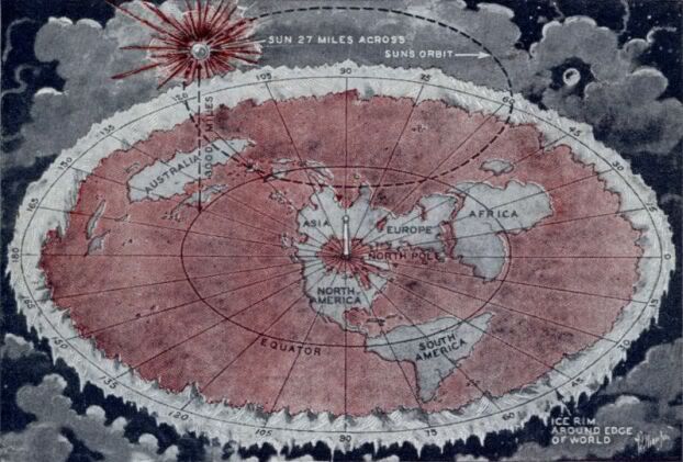
Given the FE map shown above, I'm assuming the diameter of the equator is generally accepted as 12800 Km ( same as a RE equator) (how does one estimate the diameter of an imaginary circle on a unknown flat surface? measuring the Earth).  Now, because there is never any quantifiable evidence given, I will again assume that the distance from the equator to the "ice wall" is half of the diameter of the equator, or 6400 Km.  That makes the diameter of the FE aprox. 25600 Km.

There are some interesting results of geometry between the FE and RE:

Area of a sphere is (where r = 12800 Km)
4 * pi * r^2 = 2.06 E9 Km^2

Area of a circle is (where r = 25600 Km)
pi * r^2 = 2.06 E9 Km^2

In either model Earth has the exact same area (given the assumptions above).  However,

Area of the northern circle (FE) is
pi * r^2 = 0.514 E9 Km^2 (where r = 12800 Km)

Area of the southern "ring" (FE) is
pi * r^2 - (northern circle) = 1.544 E9 Km (where r - 25600 Km)

Whereas the area of a hemisphere (RE) is
2*3.14159*(12800_Km)^2 = 1.03 E9 Km^2

Does this change the relative sizes of the north and south continents/oceans?  It definitely does between these two models, but who has actually measured them?  The government?  Probably not, because all they want is our money! (for some reason)
Now, areas are hard to qualify because they are so large (and we are so small), but distances and flight times are very easy to understand.  

Take the geodesic (shortest distance between two points on the surface of a sphere) between, say, Auckland, New Zealand and Santiago, Chile.  Having looked up a flight from Auckland, NZ to Santiago, Chile, it would take 11:20 , or 11.33 hours (if the link doesn't work look it up your damn self; took me forever) to fly a RE distance of 9690 Km .  That makes a flight speed estimate: 9690Km / 11.33 h = 855 Kph (even if I assume 30 minutes total runway taxi time, that makes flight speed 895 Kph, which is closer to the 880 Kph max efficiency speed of the Airbus 340, the plane listed in the flight itinerary).

To find the FE distance between the two cities, I will assume the latitude and longitude are the same between the two models (as is apparent on the above map) so I can simply find the distance distance between two polar coordinates on a flat surface.  

Santiago:
Because the latitude 33.47 is South from the Equator, add 90 degrees to reference the north pole.  Then multiply by 12800 Km per 180 degrees to get distance in Km.  
r1=(33.47+90)*12800/180 = 8780.09 Km (radial distance from north pole)
theta1=-70.75 = -70.75 degrees (from prime meridian)

Auckland:
r2=(36.87+90)*12800/180 = 9021.87 Km
theta2=174.8 = 174.8 degrees

Planar distance between Auckland and Santiago:
r1^2 + r2^2 - 2*r1*r2*Cos[theta1 - theta2] = 4460.19 Km

Surprisingly, the FE distance is less than half the RE distance!  I thought it would be larger because of the greater area of the southern "ring".   Keep in mind that these distances by no means follow the same path over the surface of the Earth, though.  Whereas the bearing from Auckland is Southeast on the RE, it is Northeast on the FE map.  

Remember that flight time of 11.33 hours?  
4460 Km / 11.33 h = 394 Kph

This is only 100Kph higher than take-off speed for the Airbus 340.  Or perhaps the airline wastes the following amount of hours:
11.33_h -  4460_Km / 880_Kph = 6.3 hours

That's a lot of time lost.  The airlines, pilots, and passengers must be in on the conspiracy.  

The same results are found in the northern hemisphere, too.  The distance between New York and London is shorter for the FE model:
5585 Km  on a RE
4066 Km on a FE (using the same calculation as above, except this time subtracting the latitude from 90 in order to reference the north pole as origin)

That's about a 25% shorter distance.

My Final Thought:
Just like Intelligent Design, the Flying Spaghetti Monster, UFO's, 9/11, gravity, the big bang, quantum mechanics, and on and on, there is no way to truly "know" anything.  All we can do is pick the best abstraction or estimation that fits what we observe, actually has testable hypotheses, and yields new predictions of other events.  If anything, I think the Flat Earth idea is clinging on to the absence of information and evidence about our world and calling that void a viable theory.  If you've actually read the Flat Earth Society official website it is very seriously a joke feeding on a fundamental misunderstanding of the theories on which a Round Earth model is built (for example: Argument Three - The impossibilities of holding unsecured objects in place on a curved surface.  source)
I'm not calling anyone names, nor do I plan to.  I believe the Earth is round because of the mounds of other sciences that go hand-in-hand (like astrophysics, geology, etc.) and I do not think there is substantial evidence to believe in an alternative, though it is interesting to play with other ideas.  In the words of Richard Feynman:  Why do you care what anyone else thinks?  Stop thinking and get your ass out there and do something about it if you truly do believe in it.

Pages: 1 [2]