The merged ultimate challenge for FE'ers

  • 580 Replies
  • 104670 Views
*

Tausami

  • Head Editor
  • Flat Earth Editor
  • 6767
  • Venerated Official of the High Zetetic Council
Re: The merged ultimate challenge for FE'ers
« Reply #240 on: November 16, 2011, 02:03:53 PM »
I am of course speaking of a length-preserving map, as I said about 371624 times. If the Gauss Curvature of earth is zero, such a map should exist, but FEers have so far failed to provide it. (If it's not zero, the earth is not flat.)
Well, yes, the fact that you refuse to accept certain facts and cling to your religion of mathematics does make it quite tedious. But hey, I can say it for the n+1st time. Your RET assumptions do not apply outside of RET.

Mathematics are the same no matter if the Earth is a sphere, plane, or hyperbola.

The validity of mathematics is an assumption made by both RET and FET. Live with it.

Not so. It's been questioned a few times. For instance, by Ichi.

Also, i is a copout.

*

Zogg

  • 128
  • Secret NASA space picture photoshopper
Re: The merged ultimate challenge for FE'ers
« Reply #241 on: November 16, 2011, 02:05:26 PM »

Happy?

Depends. Is this map length preserving?

If it isn't this is not what we asked for.

If it is, Australia is stretched in east-west directions by a factor of about four, compared to official local maps. Do you really think Australians won't notice?

*

Tausami

  • Head Editor
  • Flat Earth Editor
  • 6767
  • Venerated Official of the High Zetetic Council
Re: The merged ultimate challenge for FE'ers
« Reply #242 on: November 16, 2011, 02:06:00 PM »

Happy?

Depends. Is this map length preserving?

If it isn't this is not what we asked for.

If it is, Australia is stretched in east-west directions by a factor of about four, compared to official local maps. Do you really think Australians won't notice?

Look at the other one I posted. It's hard to miss.

*

Zogg

  • 128
  • Secret NASA space picture photoshopper
Re: The merged ultimate challenge for FE'ers
« Reply #243 on: November 16, 2011, 02:23:52 PM »
Look at the other one I posted. It's hard to miss.

Well, let's look at the other one you posted, and compare the shape of Australia with "official" maps:
If your map is length-preserving, that means that "official" maps would be distorted by more than the factor 2, including roads, flight distances, crop fields, streets, large buildings etc.

Do you really think nobody would notice?

Edit: Take for example the Tallaringa Conservation Park, located above the letter "S" of "South Australia" on the Google map. On the Google map, its" N-S-diameter is larger than it's E-W-diameter; on your map it would be the other way round.

Another example is the Syney airport which has an east-west runway and a north-south runway. On Google maps, the latter is longer, on your map it would be shorter.
« Last Edit: November 16, 2011, 02:40:03 PM by Zogg »

*

El Cid

  • 169
  • ...And the truth shall set you free.
Re: The merged ultimate challenge for FE'ers
« Reply #244 on: November 16, 2011, 02:52:00 PM »
I am of course speaking of a length-preserving map, as I said about 371624 times. If the Gauss Curvature of earth is zero, such a map should exist, but FEers have so far failed to provide it. (If it's not zero, the earth is not flat.)
Well, yes, the fact that you refuse to accept certain facts and cling to your religion of mathematics does make it quite tedious. But hey, I can say it for the n+1st time. Your RET assumptions do not apply outside of RET.

Mathematics are the same no matter if the Earth is a sphere, plane, or hyperbola.

The validity of mathematics is an assumption made by both RET and FET. Live with it.

Not so. It's been questioned a few times. For instance, by Ichi.

Also, i is a copout.
So you disbelieve the most basic of mathematics, and yet you often cite Special Relativity, dark energy, etc., which are based heavily on mathematics.  Just look at the gabbeldy gook on this:  http://en.wikipedia.org/wiki/Dark_energy

*

PizzaPlanet

  • 12260
  • Now available in stereo
Re: The merged ultimate challenge for FE'ers
« Reply #245 on: November 16, 2011, 03:06:43 PM »
If your map is length-preserving, that means that "official" maps would be distorted by more than the factor 2, including roads, flight distances, crop fields, streets, large buildings etc.
This is, of course, entirely untrue, for reasons explained many times now.

Also, I'm pretty sure that according to RET the Google Maps representation of Australia. I am basing this off your own claim that it's impossible to project Australia on a flat surface without distorting it; and yet, you didn't notice that, and decided to use it as your template. Perhaps it's not so outlandish of a claim that people wouldn't notice, after all?
hacking your precious forum as we speak 8) 8) 8)

*

El Cid

  • 169
  • ...And the truth shall set you free.
Re: The merged ultimate challenge for FE'ers
« Reply #246 on: November 16, 2011, 03:15:36 PM »
If your map is length-preserving, that means that "official" maps would be distorted by more than the factor 2, including roads, flight distances, crop fields, streets, large buildings etc.
This is, of course, entirely untrue, for reasons explained many times now.

Also, I'm pretty sure that according to RET the Google Maps representation of Australia. I am basing this off your own claim that it's impossible to project Australia on a flat surface without distorting it; and yet, you didn't notice that, and decided to use it as your template. Perhaps it's not so outlandish of a claim that people wouldn't notice, after all?
That map is roughly correct.  FE map is extremely distorted.

*

Zogg

  • 128
  • Secret NASA space picture photoshopper
Re: The merged ultimate challenge for FE'ers
« Reply #247 on: November 16, 2011, 03:21:31 PM »
Also, I'm pretty sure that according to RET the Google Maps representation of Australia. I am basing this off your own claim that it's impossible to project Australia on a flat surface without distorting it; and yet, you didn't notice that, and decided to use it as your template. Perhaps it's not so outlandish of a claim that people wouldn't notice, after all?

Of course, in RET, any map of Austrialia has some distortions. But first, distortions of local maps (projection on a plane tangential to a point at the center of the observed area) are small and far from factor 2, and negligable for relatively small areas such as the Sydney airport. Secondly, the distortions are well known and considered in length calculations done by professional carthographers, airline experts etc. 

*

Zogg

  • 128
  • Secret NASA space picture photoshopper
Re: The merged ultimate challenge for FE'ers
« Reply #248 on: November 16, 2011, 03:53:07 PM »
EmperorZhark asked in the opening post :

Using this:

http://www.infoplease.com/ipa/A0759496.html

Or any reliable source on distances between cities,

Find any FE map large enough to contains all continents, including Antarctica, consistant with the distances given above.

Well, let's mark two of the distances in said source on your map:


According to the source, the distance from LA to Cairo is longer than the distance from Sydney to Cape Town. On the map it's waaaay shorter - even if you pass on a "direct line" over Asia and Africa. Hence the map is not what we were asking for.

Try again.
« Last Edit: November 16, 2011, 03:55:38 PM by Zogg »

Re: The merged ultimate challenge for FE'ers
« Reply #249 on: November 16, 2011, 05:25:08 PM »
If your map is length-preserving, that means that "official" maps would be distorted by more than the factor 2, including roads, flight distances, crop fields, streets, large buildings etc.
This is, of course, entirely untrue, for reasons explained many times now.

Also, I'm pretty sure that according to RET the Google Maps representation of Australia. I am basing this off your own claim that it's impossible to project Australia on a flat surface without distorting it; and yet, you didn't notice that, and decided to use it as your template. Perhaps it's not so outlandish of a claim that people wouldn't notice, after all?

This is Pizza-code for "A round Earth would create distortions if we map it to a plane, a flat Earth would not... Therefore since we observe a distortion that is explainable by RET and not by FET, we must... CLAIM THE EARTH IS FLAT"

I will translate more, as more text becomes available.
You, sir, can't comprehend the idea of bottoms.

Re: The merged ultimate challenge for FE'ers
« Reply #250 on: November 16, 2011, 06:15:59 PM »
So, I understand the general concept that if you stretch an object, it will measure the same if you also stretch the unit of measure by the same rate.  Consider:


If you widen an object, and then widen the unit of measure by the same ratio, you get what appears to be a wider object that measures the same.  So, if you increase a pencil x2 and then increase the size of an inch by 2, voila... the pencil appears bigger, but mathematically measures the same.  So here, what we've done is changed science to give a disproven theory credence.

The problem with that is this:

Now, you have a situation where a unit of measure changes depending on its orientation.

Nobody has ever recorded this to be the case under any natural circumstance on the planet.  Now, if things grew "wider" in the South Pole, things should grow more "narrow" in the North Pole.  So, the distortion should have the opposite effect in the Northern Hemisphere.  However, like the Southern Hemisphere, an inch is the same size whether it runs N-S or E-W.

Flat Earthers attempt to explain this phenomenon with something called Electromagnetic Acceleration... which is the same principle that powers a rail gun.  Basically, their theory states that there is an electromagnetic force that gets stronger (or weaker) towards the edge of the world, which causes light to bend, giving off the illusion that something is wider than it is long.

One problem is, more than likely light can not be bent by electromagnetic acceleration. 
http://www.physicsforums.com/archive/index.php/t-4125.html
http://van.physics.illinois.edu/qa/listing.php?id=2009

This is mainly due to the theory of relativity.  Some physicists believe it could be possible, but it has never been proven.  One reason is that nobody has ever had the resources to produce an electromagnet with the kind of power a physicist would consider necessary in bending light in that fashion.  Theoretically, the Earth could provide that vehicle in the way FE Theorists suggest.  If the world is flat, the ice shelf would provide a sufficient enough size to house that kind of force.  But, there is no proof of that force, there is no proof that anything like this is happening, and there is no proof that it would even work.  Essentially, using EAT to explain FE Theory is to explain a debunked myth with an unproven phenomenon... in contradiction of a proven fact reinforced with proven science.  It's like saying, "Santa Clause can fly without upwards propulsion because he gives his reindeer magic dust.  That proves that your parents didn't buy your Christmas presents at the store."

Some FE Theorists suggest that in the dark, objects in the southern hemisphere shrink to the normal size we see when we look at satellite images of the earth.  That phenomenon is completely advocated in the FE community.  However, nobody in the FE community has explained why satellite images of land mass in the southern hemisphere more closely resemble the RE Model, nor have they explained what fills in the gaps that this supposed shrinking would create.  If the Earth is one solid object (which is one thing we can ALL agree on), if Australia, South America and Africa shrink, somewhere the ocean would need to either stretch or split to accommodate for the redistribution of volume.  Somewhere along the lines, you still have an unexplained distortion, or something has to give.

My question is, why would the continents change shape because of the absence of light?  The whole thing about light bending shouldn't have anything to do with a luminous source like a "light bulb," but the overall concept of appearance.  A flat Earth map should "look" the same in the night as it would in the day.  None of this matter though.  FET hinges on the idea that the continents are actually wider.  It's the only way to explain the southern hemisphere having more surface area, but the same measure of ratio.  Thus, the distortion wouldn't be an illusion, it would be an actual physical phenomenon.

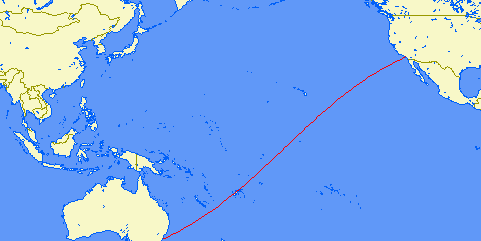
Another curious aspect about FE Theory is flight path in the northern hemisphere.  As shown in a previous post, a flight from NY to Tokyo would go over the top of the Earth rather than around it like a line of longitude.  This phenomenon holds water in FE Theory.  The shortest distance between 2 points is a straight line.  On a flat version of a RE map, this would appear as a curved path.  However, on the round earth, it ALSO appears as a straight line.  So, this particular flight path doesn't prove OR disprove FE or RE.  However, flights that take place in the Southern Hemisphere (say, a flight from Johannesburg to Melbourne) arches downward:


Flight paths in the Northern Hemisphere curve in the opposite direction than flight paths in the Southern Hemisphere simply because the Southern Hemisphere is a geometric mirror of the Northern Hemisphere.

Even when you go from Northern Hemisphere to Southern, your flight path takes an "S" pattern because a straight line across a sphere depicted on a RE Map changes direction at the equator.  That's because the equator is the divide between the halves:


If it were a conspiracy, not only would NASA be lying about it, but every commercial airline employee and every crop-duster on the planet would have to be in on it, too.

What Zogg is trying to prove is that you can't come up with a map that depicts a Flat Earth [and] accurately explains the proven geometry and geography of the Earth, as well as modern aviation methodology.  You're creating a speculated map that has never been proven, then providing a lot of circumstantial, unproven and very unlikely explanations to justify it.

A flight from Sydney to Australia is 14 hours non-stop, which is well short of the time needed to fly the 6,843 miles from point A to point B on a Flat Earth map, and WAY short of the time needed to fly the distance that the used flight path would actually take on the a flat earth.  Or, you could pay attention to REAL science, and assume that the flight path and the flight time DOES make sense, and that it DOES make a straight line by considering the following picture.  It is the ONLY way the geometry makes sense, and we've got pictures to prove it on top of everything else!  Or, you can choose to believe in a lot of flimsy debunked bull backed by a lot of junk science and conspiracy theories.

« Last Edit: November 16, 2011, 07:03:16 PM by KristaGurl »
...does anyone find it funny that the Flat Earth model is actually round?

Re: The merged ultimate challenge for FE'ers
« Reply #251 on: November 16, 2011, 06:48:56 PM »
If your map is length-preserving, that means that "official" maps would be distorted by more than the factor 2, including roads, flight distances, crop fields, streets, large buildings etc.
This is, of course, entirely untrue, for reasons explained many times now.

Also, I'm pretty sure that according to RET the Google Maps representation of Australia. I am basing this off your own claim that it's impossible to project Australia on a flat surface without distorting it; and yet, you didn't notice that, and decided to use it as your template. Perhaps it's not so outlandish of a claim that people wouldn't notice, after all?

This is Pizza-code for "A round Earth would create distortions if we map it to a plane, a flat Earth would not... Therefore since we observe a distortion that is explainable by RET and not by FET, we must... CLAIM THE EARTH IS FLAT"

I will translate more, as more text becomes available.

Even though the flat version of a flat earth model depicts more of a distortion than a flat version of the round earth model. hahaha  Especially since a spherical globe accurately depicts what we see in satellite images closer than anything else.  I wonder if he's ever considered that to be the case because the globe actually represents the geometric shape of the earth...
...does anyone find it funny that the Flat Earth model is actually round?

Re: The merged ultimate challenge for FE'ers
« Reply #252 on: November 16, 2011, 07:04:25 PM »
If your map is length-preserving, that means that "official" maps would be distorted by more than the factor 2, including roads, flight distances, crop fields, streets, large buildings etc.
This is, of course, entirely untrue, for reasons explained many times now.

Also, I'm pretty sure that according to RET the Google Maps representation of Australia. I am basing this off your own claim that it's impossible to project Australia on a flat surface without distorting it; and yet, you didn't notice that, and decided to use it as your template. Perhaps it's not so outlandish of a claim that people wouldn't notice, after all?

This is Pizza-code for "A round Earth would create distortions if we map it to a plane, a flat Earth would not... Therefore since we observe a distortion that is explainable by RET and not by FET, we must... CLAIM THE EARTH IS FLAT"

I will translate more, as more text becomes available.

Even though the flat version of a flat earth model depicts more of a distortion than a flat version of the round earth model. hahaha  Especially since a spherical globe accurately depicts what we see in satellite images closer than anything else.  I wonder if he's ever considered that to be the case because the globe actually represents the geometric shape of the earth...

But if he admitted the Earth is round, how ever would he claim that the Earth is flat?  ???
You, sir, can't comprehend the idea of bottoms.

Re: The merged ultimate challenge for FE'ers
« Reply #253 on: November 16, 2011, 07:16:17 PM »
Besides, how come Australia looks like this from space?


Wouldn't it look all stupid and distorted like it appears on the FE map?
...does anyone find it funny that the Flat Earth model is actually round?

*

PizzaPlanet

  • 12260
  • Now available in stereo
Re: The merged ultimate challenge for FE'ers
« Reply #254 on: November 17, 2011, 02:15:41 AM »
Well, let's mark two of the distances in said source on your map:


Why have you chosen to follow such weird arched paths? No wonder your results don't line up if you're not following straight lines. Also, the "even longer" line is the shortest of the lines you've drawn. What is it "even longer" than?

This is Pizza-code for "A round Earth would create distortions if we map it to a plane, a flat Earth would not... Therefore since we observe a distortion that is explainable by RET and not by FET, we must... CLAIM THE EARTH IS FLAT"
Putting words in my mouth won't get this discussion very far. What I said was: If you would like to show me what shape Australia is, as a reference point to then show that Australia doesn't look like I claim it does, please make sure that the shape of Australia you present isn't one that you have explicitly stated to be absolutely incorrect.

Of course, I am now going to follow my traditional conduct, and point out that two can play that game.

What you guys have done is RE'er code for:
"This is a circle:


This is a FE circle:


THEY CLEARLY LOOK DIFFERENT SO FET IS WROOOOOOOOOOONG!"
« Last Edit: November 17, 2011, 02:24:41 AM by PizzaPlanet »
hacking your precious forum as we speak 8) 8) 8)

*

PizzaPlanet

  • 12260
  • Now available in stereo
Re: The merged ultimate challenge for FE'ers
« Reply #255 on: November 17, 2011, 02:20:14 AM »
Krista, I've skimmed through your post (sorry, it is a bit long; I'll give it a proper read later on). Thank you for giving this thought and coming up with a serious response, rather than just attempting mockery.

You are absolutely correct in the fact that my scaling model depends on orientation. Furthermore, it also depends on distance from the North Pole. However, this only applies to optically viewed "distances" and only when scaled down. In other words - it only applies to small pictures of the whole Earth (maps). The distortion is present in optically measured "distances" in reality too, but, due to the lack of a good reference point, it would be largely unnoticeable.
hacking your precious forum as we speak 8) 8) 8)

Re: The merged ultimate challenge for FE'ers
« Reply #256 on: November 17, 2011, 03:42:38 AM »
Well, let's mark two of the distances in said source on your map:


Why have you chosen to follow such weird arched paths? No wonder your results don't line up if you're not following straight lines. Also, the "even longer" line is the shortest of the lines you've drawn. What is it "even longer" than?


Not straight lines?

Longer line shortes distance?

Might be true on RE. I don't see any FE here (no map, no math).
“The Earth looks flat, therefore it is” FEers wisdom.

*

Zogg

  • 128
  • Secret NASA space picture photoshopper
Re: The merged ultimate challenge for FE'ers
« Reply #257 on: November 17, 2011, 04:10:09 AM »
Why have you chosen to follow such weird arched paths? No wonder your results don't line up if you're not following straight lines. Also, the "even longer" line is the shortest of the lines you've drawn. What is it "even longer" than?

EmperorZark asked for a length-preserving map. Tausami posted this map ans an answer, so I supposed it was thought to be length-preserving. Now you are saying that the longest line on the map is the shortest on earth - in other words, it's not length-preserving. Hence this is not the map we were asking for.

So, either give us the map we were asking for (such a map exists for all flat surfaces), or admit that such a map does not exist (which implies that earth is not flat).

Re: The merged ultimate challenge for FE'ers
« Reply #258 on: November 17, 2011, 06:01:35 AM »
What you guys have done is RE'er code for:
"This is a circle:


This is a FE circle:


THEY CLEARLY LOOK DIFFERENT SO FET IS WROOOOOOOOOOONG!"

You gotta admit though... FET or RET, the "Pizza-code" comment was pretty humorous.  And, while we're on the subject, your profile picture is making it very hard to concentrate on mounting a sophisticated argument!  :P

So, I've been arguing that in order to make FE work, you have to change the math so the geometry makes sense.  Case in point, the diagram above isn't a circle, it's an oval.  That was kind of my point.  We're not comparing apples and oranges, we're comparing mandarin oranges and tangerines.  So, if there were a continent that was a circle with an equal radius in every direction, in order for it to work on a FE map, it wouldn't be a circle, it would be an oval. 

Maybe I'm just completely missing something you're saying.  I mean, because you explained the "stretching" with EAT.  The FAQ basically refers to EAT as "[paraphrasing] a magnetic field stretching light."  Am I just misunderstanding how that produces the phenomenon we're talking about?

Because I mean, the flight path stuff... it's not like driving a car.  You don't just drive in one direction and get there when you get there... in flight, they use proven calculations that accurately estimate arrival times based on distance and speed.  We're not talking about a small discrepency... we're talking about the difference between abotu 1,500 miles and over 7,000.  However EAT explains this geometric distortion, it either has to explain ALL of this in full, or something else has to be at play here.

And, of course his arched flight path is the longest.  If the shortest distance between 2 points is a straight line, ANYTHING else would be longer.

...does anyone find it funny that the Flat Earth model is actually round?

*

Ski

  • Planar Moderator
  • 8738
  • Homines, dum docent, dispenguin.
Re: The merged ultimate challenge for FE'ers
« Reply #259 on: November 17, 2011, 06:26:32 AM »
Planes rarely use a straight line route. They follow jet streams. The shortest route is longer.
"Never think you can turn over any old falsehood without a terrible squirming of the horrid little population that dwells under it." -O.W. Holmes "Truth forever on the scaffold, Wrong forever on the throne.."

*

markjo

  • Content Nazi
  • The Elder Ones
  • 42535
Re: The merged ultimate challenge for FE'ers
« Reply #260 on: November 17, 2011, 06:33:00 AM »
Planes rarely use a straight line route. They follow jet streams. The shortest route is longer.

What if there is no jet stream going where the plane is going?  What if the jet stream is going the wrong way?  Oh, and the shortest route is always the shortest, just not always fastest.
Science is what happens when preconception meets verification.
Quote from: Robosteve
Besides, perhaps FET is a conspiracy too.
Quote from: bullhorn
It is just the way it is, you understanding it doesn't concern me.

Re: The merged ultimate challenge for FE'ers
« Reply #261 on: November 17, 2011, 06:38:53 AM »
Planes rarely use a straight line route. They follow jet streams. The shortest route is longer.

What???  Please remember that I'm in front of a computer and all I have to do is look up what you're saying to find out if it holds water.


Yes, in some cases, but not going from Sydney to Johannesburg.  Like they'll go over the Pacific between Tokyo and LA, but even Tokyo to Washington DC (which I've flown twice), they go over the hemisphere.
...does anyone find it funny that the Flat Earth model is actually round?

Re: The merged ultimate challenge for FE'ers
« Reply #262 on: November 17, 2011, 09:19:15 AM »
Guess what?

If you tried to draw a map of the Earth using tables of distances between cities, the only map you could draw would be a globe. You could never ever draw a FE map.

So, does the impossibility of a FE map means that FE is impossible?
“The Earth looks flat, therefore it is” FEers wisdom.

*

Zogg

  • 128
  • Secret NASA space picture photoshopper
Re: The merged ultimate challenge for FE'ers
« Reply #263 on: November 17, 2011, 09:44:20 AM »
So, does the impossibility of a FE map means that FE is impossible?

I guess it depends how you define "flat".

If "flat" means "uncurved", then flat things are locally euclidean, which implies the existence of a flat, length-preserving map. Hence, if there isn't a map, there isn't any flatness. In consequence, the answer is "Yes".

If "flat" means "flatly flatish with flat flatness - but I'm not sure what this means, and I don't want to make any claims about curvature or decide on any particular geometry", then the answer is "No".

If "flat" means "I don't really believe this crap but I'm pretending to do so, as I consider defending an undefendable position a mental challenge", then the answer is "<insert confusing statement here>".
« Last Edit: November 17, 2011, 09:51:57 AM by Zogg »

Re: The merged ultimate challenge for FE'ers
« Reply #264 on: November 17, 2011, 10:59:15 AM »
Guess what?

If you tried to draw a map of the Earth using tables of distances between cities, the only map you could draw would be a globe. You could never ever draw a FE map.

That's exactly what I was trying to explain to them.  A flat map that displays accurate distances is a square peg in a round hole.  They try to play it off by saying "but RE'ers can portray a spherical earth on a flat map" as if that proves something.  We CAN'T portray a spherical earth on a flat map.  Either the map gets distorted or it gets cut or warped.  But hey... our flat version of the round earth is STILL a lot more accurate than their flat version of a flat earth... They claim the earth is the same X/Y, 2-dimensional shape as a paper map, and they STILL can't come up with a map that accurately depicts actual distances...

...unless you wanna believe in hypothetical magical electromagnetic fields that have never been proven.
...does anyone find it funny that the Flat Earth model is actually round?

Re: The merged ultimate challenge for FE'ers
« Reply #265 on: November 17, 2011, 11:19:21 AM »
And the only FE maps they provide are RE maps!
“The Earth looks flat, therefore it is” FEers wisdom.

Re: The merged ultimate challenge for FE'ers
« Reply #266 on: November 17, 2011, 11:24:56 AM »
And the only FE maps they provide are RE maps!

...with huge oceans or warped land.
...does anyone find it funny that the Flat Earth model is actually round?

Re: The merged ultimate challenge for FE'ers
« Reply #267 on: November 17, 2011, 12:02:48 PM »
And no scale, of course.
“The Earth looks flat, therefore it is” FEers wisdom.

*

Tausami

  • Head Editor
  • Flat Earth Editor
  • 6767
  • Venerated Official of the High Zetetic Council
Re: The merged ultimate challenge for FE'ers
« Reply #268 on: November 17, 2011, 12:11:48 PM »
Guess what?

If you tried to draw a map of the Earth using tables of distances between cities, the only map you could draw would be a globe. You could never ever draw a FE map.

So, does the impossibility of a FE map means that FE is impossible?

Only with RE distances

Re: The merged ultimate challenge for FE'ers
« Reply #269 on: November 17, 2011, 12:14:16 PM »
Then provide us with FE distances! (never done before)
“The Earth looks flat, therefore it is” FEers wisdom.