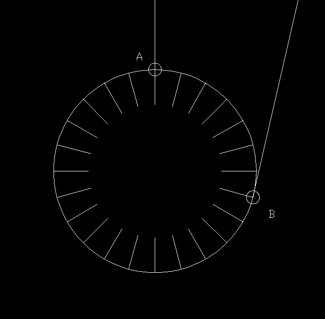
Here is an example of how Sandokhan misinforms the readers. He submits this image to visually demonstrate how far the event and London are from each other with the following description of the image:
 Here is a diagram of what this would look like. The large circle represents a cutaway of a spherical Earth. I divided the Earth into 24 evenly spaced time zones. Point A represents an event happening. Point B represents an observer 7 time zones away. The line extending along the horizon at point B represents the line of view of the person at that point. He would never see the event happen.
A spherical earth is said to have a circumference of 24,901 miles. That number divided by 24 gives us time zones of 1037.5 miles each. Multiply that by the 7 times he uses and we get roughly 7262 miles between the Tunguska event and London.
There are two major considerations in his model that are completely flawed and one is minor (but still important) while the other is major.
- The minor issue is time zones - The way he represents the distance between the event and london is by just taking the entire earth and dividing into equal time zones. At the same time he places london at the start of the 1st time zone and places Tunguska at the end of the 7th time zone. Time zones are not always equidistant from each other in reality, especially over land, but even ignoring that and using imaginary perfect time zones we can see that London is actually about in the center of the first time zone and the Tunguska event is near the western border of the 7th time zone.
- The major issue is that the shortest distance between any 2 points on a sphere is an arc called the great circle - The graphic Sandokhan made would be applicable if we were talking about 2 locations that were along the equator but we are not. The only place on earth where the entire circumference is spanned while simultaneously giving time zones their maximum distance is the equator. London is about 50° N of the equator and the Tunguska event is about 60° N of the equator. At this latitude the distance between times zones is significantly smaller. The proper way to understand the distance between these locations is not through the use of time zones. It is by using a great circle.
I have calculated myself by using Google Earth that the actual distance between these two locations using a great circle is 3,570 miles. This is a far cry from the 7,262 miles Sandokhan was attempting to lead his readers to believe.
On the circular representation of the sphere that is earth that Sandokhan used he placed Tungaska event (point B) at about the 104° mark on a circle. Using the correct distance of 3,570 miles this spot on the circle should actually be at 51°. This is less than half the distance that he implied.
I will have more to say about this in future as I do more research.